[7:22AM MON 11/25/24] WINTER WEATHER ADVISORY IS UP FOR WINDHAM COUNTY IN SOUTHEAST VT FOR FREEZING RAIN ON TUESDAY MORNING… TODAY IS PICK OF THE WEEK… NEEDED SHOWERS TUESDAY, THEN BREEZY/COOLER ON WEDNESDAY… RAIN AND SNOW WITH A MODERATE-TYPE STORM SYSTEM IMPACTS THANKSGIVING AFTERNOON INTO FRIDAY, DETAILS UNCLEAR STILL… WINTER IS COMING… MUCH COLDER FOR THIS WEEKEND INTO EARLY NEXT WEEK AS COLDEST OF THE NEW SEASON ARRIVES INTO DECEMBER… GIVE THE GIFT OF WARMTH AND COMFORT BY SHOPPING DAVE’S 2024 HOLIDAY APPAREL SALE WHICH ENDS A WEEK FROM TODAY (LINKS BELOW)….

HOODIES, LONG SLEEVES, TEES & MORE
#1. Snow Lover’s Triangle of Disappointment
HATS
#3. Weather Nut Hats
DAVE’S 2025 CALENDARS
Still need a 2025 Calendar or holiday gift idea?
~~~~~~~~~~~~~~~~~~~~~~
TABLE OF CONTENTS
* Daily Celestials (Sun/Moon Data)
* Sponsor Note
* Dave’s 2024 Apparel Sale Live (Hats, Hoodies, Tees & More)
* Morning Discussion
* TIP: Scroll below for sections, or read all
~~~~~~~~~~~~~~~~~~~~~~
YOUR DAILY CELESTIALS
~~~~~~~~~~~~~~~~~~~~~~
STAR:
–OUR STAR ROSE AT: 6:53am this morning
–OUR STAR WILL SET AT: 4:21pm this evening
–TOTAL DAYLIGHT TIME: 9 hours and 28 minutes
MOON:
–OUR MOON WILL SET AT: 1:37pm this afternoon
–MOON SET DIRECTION: West
–OUR MOON WILL RISE AT: 2:18am tomorrow morning
–MOON RISE DIRECTION: East
–MOON PHASE: Waning Crescent (27.7%)
~~~~~~~~~~~~~~~~~~~~~~
A NOTE FROM OUR SPONSOR
~~~~~~~~~~~~~~~~~~~~~~
Dave Hayes The Weather Nut is Sponsored by Individual Community Members, Patrons, and Tandem Bagel Company… No matter the weather, Tandem Bagel is always there for you at several valley locations to make your mornings brighter! With *New Pizza Bagels(!)*, along with bagels baked fresh daily (including Gluten-Free options), house-whipped cream cheese, coffee, and tons of lunch options, Tandem is the perfect quick stop for lunch, breakfast, or a coffee and bagel to go.
You can either 1) visit them in Easthampton, Northampton, Hadley, Florence, and/or West Springfield, 2) hire them to cater your next event, or 3) use their super-streamlined online ordering tool by visiting their website and clicking the “Catering” or “Order Online” links.
~~~~~~~~~~~~~~~~~~~~~~
DAVE’S 2024 APPAREL SALE ENDS DEC. 2ND
~~~~~~~~~~~~~~~~~~~~~~
Need Holiday Gifts, or wanna stay toasty this Winter?
HOODIES, LONG SLEEVES, TEES (Classic)
#1. Snow Lover’s Triangle of Disappointment
HATS
#3. Weather Nut Hats
DAVE’S 2025 CALENDARS
~~~~~~~~~~~~~~~~~~~~~~
YOUR MORNING DISCUSSION
~~~~~~~~~~~~~~~~~~~~~~
Good morning everybody, to just splash cold water on all of our faces at the outset, I have three words for you – Winter is Coming.
The pattern has changed, and it’s time to get the colder weather gear out as the coldest air mass of the incoming cold season is set to arrive just after Thanksgiving on the heels of a coastal storm that at this point looks to produce a light to moderate impact of rain and snow across the region, though details are short as of this writing (I will discuss this further along in this report).
First, we start with our Monday, and it looks like the pick of the week with light breezes, mostly sunny skies, and highs in the 45-50º range. Clouds will increase tonight with lows in the upper 20s to low 30s.
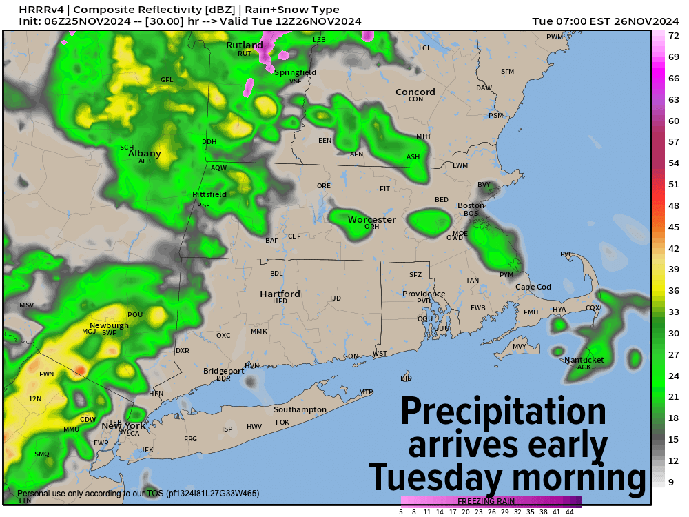
Winter Weather Advisories are up for Windham County VT for Tuesday morning, because as a storm tracks into southern Quebec and sweeps its cold front towards southern New England, temps will dip to and just below freezing, setting the stage for freezing rain for some higher terrain areas.
I would not be surprised to see some icing occurring in far western Franklin County and northeast Berkshire County in WMass early on Tuesday as well, so give yourself extra travel time tomorrow morning, as it could become slippery.
Precipitation moves in between 5-8am, and the rest of us will see periods of rain showers into the mid-afternoon before the front sweeps east and out of here. Some rain may be heavier if a secondary low forms along the front in our region, and everybody who sees any ice in the morning turns to plain rain by late morning or so.
Highs Tuesday will reach the upper 40s to low 50s, and then we’ll skies out Tuesday night with lows in the upper 20s.
Wednesday looks a bit blustery with westerly wind gusts behind the front pushing up to 25mph at times under mostly sunny skies with cooler highs in the firmly in the 40s, with lows upper 20s to low 30s as clouds increase ahead of what looks to be a coastal “slider”.
A storm on Thanksgiving Day will be tracking east-northeast toward New England, and assuming the upper trough maintains a forward/positive orientation, this will keep the storm from amplifying or deepening too much, but would also keep us on the cooler side of the storm.
Depending on when the storm arrives (Thursday afternoon or evening), some of us could see light to moderate snowfall, with others seeing a mix of rain and snow, or even plain rain down into northern CT.
This could negatively impact travel, especially Thanksgiving afternoon and night, and storminess may linger into Friday as well.
Lots can change even in the next 3-4 days, so I will update you at least twice a day through this week to stay on top of trends and changes in the forecast, as Thanksgiving is one of the busiest travel periods of the year.
Highs will only be in the mid 30s to mid 40s Thursday and Friday, and then by this coming weekend (behind our late-week storm) the coldest air of the new cold season dumps into the greater WMass region, lasting into at least early next week with highs in the 30s, and lows in the teens, so gear up folks, wintry conditions are incoming.
Have a great day!
“Follow your bliss and the universe will open doors for you where there were only walls.”
― Joseph Campbell
