***Warm and Cozy 2024 Apparel Sale… Local Holiday Gift Ideas***
#1. Snow Lover’s Triangle of Disappointment
#2. Classic DHTWN Logo Design
~~~~~~~~~~~~~~~~~~~~~~
TABLE OF CONTENTS
* Daily Celestials (Sun/Moon Data)
* Sponsor Section
* Morning Discussion
* TIP: Scroll to your section, or read all
~~~~~~~~~~~~~~~~~~~~~~
YOUR DAILY CELESTIALS
~~~~~~~~~~~~~~~~~~~~~~
STAR:
–OUR STAR ROSE AT: 6:51am this morning
–OUR STAR WILL SET AT: 4:22pm this evening
–TOTAL DAYLIGHT TIME: 9 hours and 31 minutes
MOON:
–OUR MOON WILL SET AT: 1:20pm this afternoon
–MOON SET DIRECTION: West
–OUR MOON WILL RISE AT: 1:18am tomorrow morning
–MOON RISE DIRECTION: East
–MOON PHASE: Waning Crescent (36.0%)
~~~~~~~~~~~~~~~~~~~~~~
>>> A NOTE FROM OUR WEEKEND SPONSOR <<<
Dave Hayes The Weather Nut is Sponsored by Individual Community Members, Patrons, and Gerard, Ghazey & Bates, P.C. GGBPC is a Northampton-based law firm regarded as the voice of pragmatic and well-reasoned estate planning, elder law and tax guidance in Western Massachusetts. The firm specializes in estate planning law, and expertly handles other matters such as Elder Law, Tax Law, as well as Real Estate purchase, sales, and refinance transactions. Contact GGBPC today to see how they can help!
~~~~~~~~~~~~~~~~~~~~~~
YOUR MORNING DISCUSSION
~~~~~~~~~~~~~~~~~~~~~~
Good morning folks, we’ve got another blustery day on the way with northwest wind gusts kicking up to 25-40mph at times (Pittsfield Muni Airport already clocked a 41mph gust), so bundle up if you’re outside doing stuff.
We’ve got a tighter surface pressure gradient migrating west to east over the greater WMass region between incoming high pressure and our outgoing low pressure system that brought soaking rains, and some high terrain snow to us over the past couple of days.
Highs will reach the low to upper 40s under partly to mostly sunny skies from SVT and far northwest MA down into the southern valley and points south and east into CMass and northern CT.
Wind will die down later tonight, but may be breezy up to 25mph or so in the early evening. Lows will fall into the upper 20s to low 30s.
For Monday, the pick of the week arrives, with comparatively mild highs in the mid 40s to low 50s as a weak southerly flow develops as high pressure crests through the region.
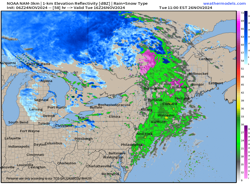
However, a storm system that is set to track east through southern Canada and far northern New England will be quickly clouding up our skies Monday night with lows dropping into the upper 20s to mid 30s.
Depending on how early first showers make it into our region, we could see some snow or mixed precip in the late pre-dawn hours as first showers arrive, so that could briefly impact travel.
Otherwise, given that we are on the south side of the storm, plenty of milder air will get pulled northward into our region to produce a period of rain showers Tuesday morning into the early to mid-afternoon before the front clears east of our region.
Highs Tuesday will again climb into the mid 40s to low 50s, and then I don’t think we’ll see temps cresting 50º for a good while as we descend into late Autumn, heading toward early Winter.
As we dry and clear Tuesday night, lows will dip into the low 30s for lows.
By Wednesday, another blustery (yet sunny) day is expected with westerly gusts up to 25mph possible, plenty of sunshine, and highs in the upper 30s to upper 40s, and at night, lows will bottom out in the mid to upper 20s with clouds increasing.
The good news is that pre-Thanksgiving travel in our region will be dry and uneventful. However, on Thanksgiving Day into Friday, I can’t rule out the first accumulating snowfall for many of us of the new cold season, or at least snow to rain mix.
Now, we’re still 4-5 days away, and lots can change, but it does look like a storm ejecting out of the northern Mississippi Valley will be drawn east-northeast, and potentially interact with the northern branch of the jet stream and a disturbance in that flow. If those two systems meet up, and interact in such a way as to keep the southern storm from hooking north too fast, we could see a light to moderately-sized wet snowstorm in our region by Friday.
Regardless of what happens with any storminess in the Thursday/Friday timeframe, behind that system, we will see coldest air of the new cold season be dumped into the greater WMass region next week with highs potentially only in the 30s with lows in the teens!
Lots going on, and while I’m drawing breath, I will keep you updated best I can, so please have a great day, and remember: If you want some cozy, quality apparel (or a 2025 weather calendar), check out my offerings below, as the apparel holiday sale ends Dec. 2nd:
***Warm and Cozy 2024 Apparel Sale… Local Holiday Gift Ideas***
#1. Snow Lover’s Triangle of Disappointment
#3. 2025 Weather Wall Calendar
(Securely Order via Cards, Venmo, PayPal, Check)
“Follow your bliss and the universe will open doors for you where there were only walls.”
― Joseph Campbell
