MY 2023 WEATHER CALENDAR SALE ENDS ***TONIGHT***
It’s western Mass captured in a calendar, you get to…
–Relax with wonderfully serene WMass landscapes
–Connect to your Love for the WMass region
–Educate yourself about WMass’ most powerful storms
–Savor my relaxing weather haiku poetry
–Understand our weather deeply by learning about how it forms
–Peruse storm summaries, or explore deep-dives into storm details on my website, exclusive to you when you order today
CLICK & VIEW PHOTOS, GET INFO, OR ORDER.
——————————-
WEEKLY WEATHER NUTSHELL
Well hello there, my friends, it’s cold out! As if that’s news… but wait, there’s more! It’s getting colder, windier, and for some, snowier.
Well, not that snowy, but we do have some snow showers into the Berkshires this morning tracking east with a snow burst possible along with gusts as a cold front brings wind, cold and more snow showers north of the Pike this afternoon, followed by more wind and cold Monday, a mildening into mid-week with fair weather through Thanksgiving and a possible mixed-bag big coastal storm Friday into Saturday, but before we dive into all of the weather details below, let’s check a note from our new local weekend sponsor, #CranberryHillHealingArts located in Amherst, MA.
——————–
A NOTE FROM OUR WEEKEND SPONSOR:
DHTWN is sponsored by members, patrons, and Cranberry Hill Healing Arts. The turning of the seasons can be challenging, and Carolyn Walker of Cranberry Hill Healing Arts in Amherst is there for you. When you are searching for ways to be at peace, seek relaxation, and feel more energetic, let Reiki & Sound Healing guide you on your journey to wholeness. Through energy work and the gentle vibrations of singing bowls, chimes, and chanting, Carolyn crafts a safe and calming space to experience renewal. Learn more and/or book your session today by visiting their website.
——————————————-
***DHTWN DAILY WEATHER REPORT***
——————————————-
Good morning everybody, we’re in the midst of our first real early-winter weather stretch here, and today launches the core of the cold moving in from the Great Lakes behind a series of cold fronts that are set to deliver some snow showers, and more importantly, windy conditions that may cause a few isolated outages so if you’re a hilltowner prone to outage in wind events, gas up the generators and get the wood ready, if you’re so prepared and/or fortunate, given that it will be quite cold over the next couple of days and nights.
For today, we have a strong cold front swinging east into the greater WMass region and ahead of that exists a line of snow showers that will send some flakes a flyin’ early this morning.
We’ll have mostly sunny skies, but there will be periods of clouds associated with these snow showers this morning, and by mid afternoon into the early evening, mainly north of the MassPike.
Highs will only reach the upper 20s to mid 30s today: a true winter day!
Some snow showers may become briefly heavy and there’s a low chance of a snow squall which could combine wind and heavy snow to produce issues with visibility and locally slick roads during the mid to late afternoon north of the Pike, and especially along either side of the Rt. 2 corridor.
Winds will become a main weather headline today with gusts in the 25-40mph range behind the front, with some at elevation seeing gusts up to 50mph lasting into this evening, so hold on to your hats, and stay inside given that wind chills will put us into the low teens for a feels-like temp.
For tonight, the coldest night of the new season arrives with lows in the mid to upper teens and wind gusts continuing to blow 20-40mph at times.
For Monday, we’ll enjoy a fair weather day with sunshine and highs in the mid 30s to low 40s and light southwest wind. However, another shortwave will be passing through the region to our north, and this will kick up the wind tomorrow evening gusting 20-30mph at times with lows in the mid 20s.
Tuesday through Thanksgiving look quite nice with sunshine, calmer wind, and highs in the mid to upper 40s, comparatively balmy to today, but still WAY colder than our recent and final warm surge. Lows will be in the 20s.
So the bottom line is that travel preceding and including Thanksgiving looks ideal, to be honest, so that’s good news.
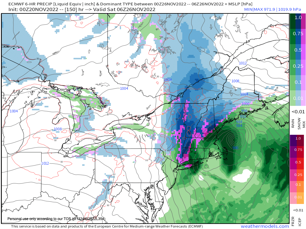
However, once the clock strikes midnight, all bets our off as a strong-looking east coast storm system looks like it will muster some meteorological forces and combine with an upper trough digging into the eastern U.S. and form along the Appalachian Mountains and track northeast.
This storm may hit with its brunt late Friday night and this could produce a period of snow or ice in the Berkshires, hilltowns, SVT, etc., so stay tuned for updates on our Friday to Saturday period, because it continues to look stormy, which may impact travel plans coming home from Thanksgiving.
Folks, clearly I don’t want you to get something you don’t want or need, but my 2023 calendar sale ends TONIGHT, and I promise you that it’s a really good piece, and whether it’s for you personally or for others as gifts, the time to order is truly *now*.
I have sold out in the past, and it’s my charge to get these to you in time for the holidays and new year. I’d be so grateful if you did some holiday or calendar shopping with me this year, so just click below to order or info, and thank you!
SECURE CALENDAR ORDER/INFO LINK
You can also follow me on Twitter
AND REMEMBER…
“Hello babies. Welcome to Earth. It’s hot in the summer and cold in the winter. It’s round and wet and crowded. On the outside, babies, you’ve got a hundred years here. There’s only one rule that I know of, babies: Goddamn it, you’ve got to be kind.”
–Kurt Vonnegut
