[8:08AM SAT: 11/2/24] DAYLIGHT SAVING TIME BEGINS TONIGHT… NEWS ON ACTIVE FLORENCE, MONSON AND SPENCER BRUSH FIRES WELCOME BELOW THIS POST… A PLEASANT, COOLER WEEKEND LIES AHEAD… WARMER NEXT WEEK, ESPECIALLY THE FIRST HALF WITH MORE RISK OF BRUSH FIRE SPREAD DUE TO GUSTIER SOUTHERLY WINDS EXPECTED TUESDAY INTO WEDNESDAY… AGAIN, PAUSE ANY BURNS OR CAMPFIRES AND PROPERLY DISPOSE OF CIGS ETC… MY 2025 CALENDAR SALE ENDS NEXT SUNDAY, IF YOU WANT ONE FOR YOURSELF OR AS GIFTS FOR YOUR PEEPS (LINK BELOW)…

Dave’s 2025 Weather Wall Calendar packs a lot into one piece:
(Securely Order via Cards, Venmo, PayPal, Check)
~~~~~~~~~~~~~~~~~~~~~~
TABLE OF CONTENTS
* Daily Celestials (Sun/Moon Data)
* Sponsor Section
* Morning Discussion
* TIP: Scroll to your section, or read all
~~~~~~~~~~~~~~~~~~~~~~
YOUR DAILY CELESTIALS
~~~~~~~~~~~~~~~~~~~~~~
STAR:
–OUR STAR ROSE AT: 7:25am this morning
–OUR STAR WILL SET AT: 5:42pm this evening
–TOTAL DAYLIGHT TIME: 10 hours and 17 minutes
MOON:
–OUR MOON WILL RISE AT: 8:38am this morning
–MOON RISE DIRECTION: East-Southeast
–OUR MOON WILL SET AT: 5:59pm this afternoon
–MOON SET DIRECTION: West-Southwest
–MOON PHASE: Waxing Crescent (1.0%)
~~~~~~~~~~~~~~~~~~~~~~
>>> A NOTE FROM OUR WEEKEND SPONSOR <<<
Dave Hayes The Weather Nut is Sponsored by Individual Community Members, Patrons, and Gerard, Ghazey & Bates, P.C. GGBPC is a Northampton-based law firm regarded as the voice of pragmatic and well-reasoned estate planning, elder law and tax guidance in Western Massachusetts. The firm specializes in estate planning law, and expertly handles other matters such as Elder Law, Tax Law, as well as Real Estate purchase, sales, and refinance transactions. Contact GGBPC today to see how they can help!
~~~~~~~~~~~~~~~~~~~~~~
YOUR MORNING DISCUSSION
~~~~~~~~~~~~~~~~~~~~~~
Good morning everybody, thanks for all of the reports last evening about the ongoing brush fires in Florence (Fitzy Lake), Monson and Spencer. Let me know if you know of any others. Below are thee FB pages of the 3 respective fire departments/squads for updates:
NORTHAMPTON FIRE DEPT
https://www.facebook.com/NorthamptonFireRescue
MONSON FIRE DEPT
https://www.facebook.com/MonsonfireMA
SPENCER FIRE DEPT
https://www.facebook.com/SpencerFireDepartment
As for our risk of further fire spread, at least the wind has come down, and that should continue through about Monday, but there is very little rain in sight, and winds are expected to ramp back up on Tuesday and Wednesday with southerly gusts of 20-30mph, so this problem is not going away in the short term.
These fires are caused by human carelessness as there are no thunderstorms bringing lightning strikes to the region to ignite active blazes.
All I’m asking is don’t be one of those people if you are looking to burn brush piles, or want to have a cookout, or a campfire, or you smoke… take a pause and think of your larger community to not exacerbate what is the most active brush fire situation I have ever seen living in Massachusetts my entire life.
As for our weather, your BoreCast is found below!
–A few light sprinkles are possible in SVT and the northern Berkshires early
–Otherwise, lighter NW wind and highs in the upper 40s to mid 50s under partly to mostly sunny skies expected
–Radiational cooling maximizes with lows in the low to upper 20s, quite cold under clear skies
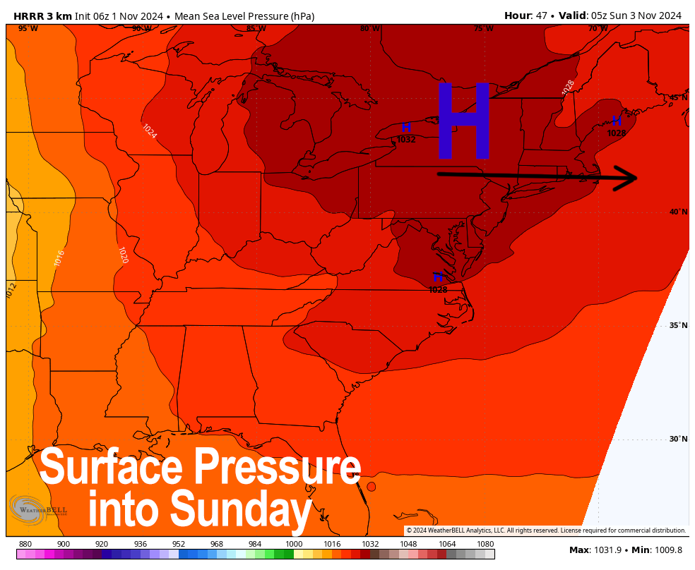
–For Sunday, high pressure continues to build into the region from our west
–Mostly sunny skies are expected with highs again in the upper 40s to mid 50s, with lows in the 20s under partly cloudy skies
–By Tuesday, the high gets under us and induces southerly flow as a weak shortwave moves into the region from our west
–This will help produce more gusty winds with gusts of 20-30mph
–Should this manifest, fires will be able to spread further, and Red Flag Warnings would likely be hoisted again
–After highs in the 50s on Monday, temps will rise into the 60s and 70s again Tuesday and Wednesday under partly sunny skies
–Another dry cold frontal passage drops our temps into the 60s Thursday and 50s to low 60s by Friday with more fair weather expected
–No end to this dry pattern seen currently, with drought expected to worsen and fire spread conditions expected to persist
Please post any concrete information on active brushfires in the region under this post, and say a prayer for the brave firefighters trying to protect our region and homes and businesses.
After 13 years of running this resource, it’s your support that keeps it going, and I’m offering my final edition, local-color-rich calendar this season… sale ends next Sunday, so now’s the time to order for yourself or as holiday gifts, link is below, check it out!
2025 DHTWN Weather Wall Calendar
(Securely Order via Cards, Venmo, PayPal, or Check)
HAIKU OF THE DAY:
Don’t be a dumb dope
Fire spread danger is active
Stop outside fires, please
“Follow your bliss and the universe will open doors for you where there were only walls.”
― Joseph Campbell
