
———————
JOAN AXELROD-CONTRADA SHARES HER LOVE
OF DAVE’S 2023 WEATHER CALENDAR:
“Hey Dave, I loved your October haiku so much. (“Autumn winks at us” made me smile) that I hated having to turn the page. But your November haiku is great, too!!! Look forward to reading more in 2023!”
ORDER 2023 CALENDAR HERE
———————
DAVE’S WEEKLY NUTSHELL
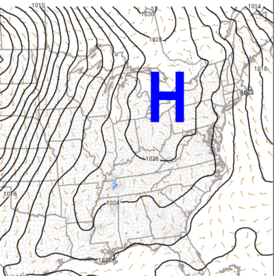
Good morning folks, we’ve got tons o’ sunshine on the way into early next week thanks to a big ol’ high pressure system draped across eastern North America.
This system will slowly move east, produce warming temps and fair weather (though it will be chilly tonight) with near record setting warmth this weekend, and will be followed by some Sunday night showers with more showers and cooler temps by mid week, but before we jump into the details, let’s check a note from our local and delicious sponsor, #TandemBagelCo, with their newest location in West Springfield, MA.
——————–
A NOTE FROM OUR SPONSOR:
DHTWN Is Sponsored by Members, Patrons & Tandem Bagel Company: No matter the weather, Tandem Bagel is always there for you at several valley locations to make your mornings brighter! With bagels baked fresh daily (including Gluten-Free options), house-whipped cream cheese, coffee, and tons of lunch options, Tandem is the perfect quick stop for lunch, breakfast, or a coffee and bagel to go. Find them in Easthampton, Northampton, Hadley, Florence, and West Springfield, or use their super-streamlined online ordering tool by visiting their website.
——————————————-
***DHTWN DAILY WEATHER REPORT***
——————————————-
NWS ALERTS
–None
DHTWN REMINDER
–The odds of being a human is 1 in 400,000 billion… make it count, even in a small way (see Kurt Vonnegut quote at end of post)
DAILY CELESTIAL (STAR):
–OUR STAR RISES AT: 7:24am this morning
–OUR STAR WILL SET AT: 5:42pm this evening
–TOTAL DAYLIGHT TIME: 10 hours and 18 minutes
DAILY CELESTIAL (MOON):
–OUR MOON WILL RISE AT: 3:20pm this afternoon
–OUR MOON WILL SET AT: 1:48am tomorrow morning
–MOON RISE DIRECTION: East-Southeast
–MOON SET DIRECTION: West-Southwest
–MOON PHASE: Waxing Gibbous (63.3%)
———————-
DAILY TERRESTRIAL (ZoneCast)
ZONE 1 (Northern Region)
Southern VT, Southwest NH, N. Taconics NY
–High Temps: Low to Mid 60s
–Low Temps: Low to Mid 30s
–Wind: Light North
–Skies: Mostly sunny
–Precipitation: None
ZONE 2 (Central Region)
WMass, N. CMass, N. Litchfield County, C./S. Taconics NY
–High Temps: Mid to Upper 60s
–Low Temps: Mid to Upper 30s
–Wind: Light North
–Skies: Mostly sunny
–Precipitation: None
ZONE 3 (Southern Region)
S. CMass, S. Litchfield County, NC.CT, & NE.CT
–High Temps: Upper 60s to Low 70s
–Low Temps: Mid to Upper 30s
–Wind: Light North
–Skies: Mostly sunny
–Precipitation: None
———————-
WEATHER REPORT
Good morning everybody, we’re going on a short-and-sweet reporting ride today, my friends, as a big ol’ high pressure system draped up and down eastern North America soundly and handily will dominate our weather conditions with plenty of sunshine and warming temperatures for days to come!
We have a few patchy fog spots to burn off this morning, notably in central Hampden County, but temps will rebound nicely well into the 60s with a few 70º readings expected under sunny skies.
Light north wind today goes calm tonight as high pressure crests into the greater WMass region, which will drop temps into the low to mid 30s, so some patchy frost is possible, especially in northern MA up into SVT / SWNH.
For Thursday and Friday, sunshine continues with mild temps in the mid to upper 60s, and with lows in the low 40s Thursday night and near 50º by Friday night.
The weekend will be even warmer, when some records may be broken, especially for Sunday.
Highs will reach into the low 70s both days, and maybe some mid 70s. Lows will be in the 50s.
Saturday is the weekend pick with partly sunny skies, as a warm front will be tracking into the region by sometime on Sunday, draped off of a low pressure system that is forced to ride far north of us due to the upper ridge in place.
By Sunday morning and during the day some scattered showers are possible, and lows will dip into the 50s.
Monday looks sunnier and warm, again with highs upper 60s to low 70s, but that aforementioned storm’s cold front will be approaching by Tuesday and likely move through by mid week.
This will drop temps back towards average for this time of year, which is in the 50s for highs and upper 20s to 30s for lows, with more rain possible late next week.
Have a great day, and if you’re the type that loves to support local folks and want/need wall calendars for you or others, check out my very giftable 2023 weather wall calendar which is rich with WMass history, education, beauty and practicality – it’s my best offering in 9 years, and I believe you won’t be disappointed with its quality and utility – it’s much more than a calendar: it’s a local weather history mini-book.
Did you know that you can also follow me on Twitter?
AND REMEMBER…
“Hello babies. Welcome to Earth. It’s hot in the summer and cold in the winter. It’s round and wet and crowded. On the outside, babies, you’ve got a hundred years here. There’s only one rule that I know of, babies: Goddamn it, you’ve got to be kind.”
–Kurt Vonnegut