
TABLE OF CONTENTS
* Daily Celestials (Sun/Moon)
* Sponsor Section
* Your Short-Term ZoneCast
* Morning Discussion
~~~~~~~~~~~~~~~
YOUR DAILY CELESTIALS
~~~~~~~~~~~~~~~~~~~~~~
STAR:
–OUR STAR ROSE AT: 5:39am this morning
–OUR STAR SETS AT: 7:545pm this evening
–TOTAL DAYLIGHT TIME: 14 hours and 16 minutes
MOON:
–OUR MOON RISES AT: 2:14pm this morning
–MOON RISE DIRECTION: East-Northeast
–OUR MOON SETS AT: 3:25am tomorrow morning
–MOON SET DIRECTION: West
–MOON PHASE: Waxing Gibbous (68.5%)
~~~~~~~~~~~~~~~~~~~~~~
A NOTE FROM OUR SPONSOR
~~~~~~~~~~~~~~~~~~~~~~
Dave Hayes The Weather Nut is Sponsored by Individual Community Members, Patrons, and Tandem Bagel Company… No matter the weather, Tandem Bagel is always there for you at several valley locations to make your mornings brighter! With *New Pizza Bagels(!)*, along with bagels baked fresh daily (including Gluten-Free options), house-whipped cream cheese, coffee, and tons of lunch options, Tandem is the perfect quick stop for lunch, breakfast, or a coffee and bagel to go.
You can either 1) visit them in Easthampton, Northampton, Hadley, Florence, and/or West Springfield, 2) hire them to cater your next event, or 3) use their super-streamlined online ordering tool by visiting their website and clicking the “Catering” or “Order Online” links.
~~~~~~~~~~~~~~~~~~~~~~
YOUR SHORT-TERM ZONECAST
~~~~~~~~~~~~~~~~~~~~~~
ZONE 1 – Northern Region
(Southern VT, Southwest NH)
–Highs Today: Low to Mid 60s
–Lows Tonight: Low to Mid 50s
–Highs Tomorrow: Mid to Upper 60s
–Winds: Southeast gusts 10-20mph today, light south to southwest tonight/tomorrow
–Skies: Overcast through tomorrow
–Precip: Periods of rain today, with less activity tonight. Upper low passage may bring more showers Wednesday
–NWS Alerts + Nut Notes: Patchy fog or drizzle is expected at times, along with street flooding.
ZONE 2 – Central Region
(Western MA, North-Central MA, Northern Litchfield CT)
–Highs Today: Low to Upper 60s
–Lows Tonight: Low to Mid 50s
–Highs Tomorrow: Mid to Upper 60s
–Winds: Southeast gusts 10-20mph today, light south to southwest tonight/tomorrow
–Skies: Overcast through tomorrow morning, some partial sunshine possible late Wed. PM
–Precip: Periods of rain today, with less activity tonight, though CMass may rain for longer tonight… Upper low passage north should keep Wednesday drier, though isolated showers expected
–NWS Alerts + Nut Notes: Patchy fog or drizzle is expected at times, along with street flooding.
ZONE 3 – Southern Region
(South-Central MA, Northern CT)
–Highs Today: Mid to Upper 60s
–Lows Tonight: Mid 50s
–Highs Tomorrow: Upper 60s
–Winds: Southeast gusts 10-20mph today, light south to southwest tonight/tomorrow
–Skies: Overcast through tomorrow morning, some partial sunshine possible late Wed. PM
–Precip: Periods of rain today, with less activity tonight though CMass may rain longer tonight… Upper low passage north should keep Wednesday drier, though isolated showers expected
–NWS Alerts + Nut Notes: Patchy fog or drizzle is expected at times, along with street flooding.
~~~~~~~~~~~~~~~~~~~~~~
YOUR MORNING DISCUSSION
~~~~~~~~~~~~~~~~~~~~~~
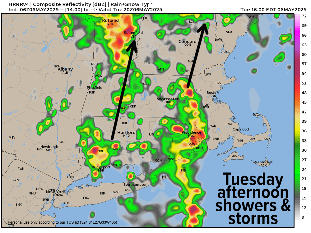
Good morning folks, our stalled upper low responsible for our recent dreary conditions is weakening over Ohio and far western PA. As such, its “tendrils” of showers in the outer bands of its cloud shield that are running south to north into the greater WMass region are starting to weaken a bit and become more sporadic with areas of less precipitation.
Still, we have one more day with periods of heavier rainfall at times, with that whole complex of showers working north slowly translating east of the I-91 corridor, putting CMass, eastern CT, RI and EMass into the heavier rains by this evening and tonight, and less so in western CT, western MA and SVT/SWNH.
There are some thunderstorms developing south of New England over the ocean, so those could rummage through the region later today as well.
Highs will be mostly in the 60s, with lows in the 50s tonight and scattered showers are still expected, especially east of the I-91 corridor, with less activity in the valley points west.
Patchy fog and/or drizzle is expected in spots today and tonight, as well as isolated street flooding.
Flood Watches continue until 8pm, and again I am looking at the western hilltowns where Ashfield, MA has received over 6” of rain since Saturday. Any isolated flash flooding threat would develop in the western hilltowns, if anywhere I believe.
For Wednesday, we’re looking better as it appears that our upper low will be lifting more northeast. While SVT and SWNH could see more shower activity tomorrow as a result, in MA, CT, and RI we should see drier conditions with isolated shower activity, and maybe even a few glimpses of sunshine by afternoon.
Highs should reach the 65-70º range, with lows in the upper 40s to low 50s as any isolated showers come to an end.
For Thursday, the pick of the week arrives with at least partial sunshine and highs in the 60s, as clouds fill back in later in the day.
Some showers are possible at night, but the next storm story will involve a second trough in the eastern U.S. spawning a surface low in the Mid-Atlantic region, and producing another rainstorm for Friday into Saturday, the way it looks now.
This could be another significant rainfall event, with highs in the 50s Friday, the 60s Saturday, and then by the time things wind down Saturday night into Sunday, we could reach the 70s on Sunday and Monday with high pressure and sunshine returning, so Sunday is DEFINITELY looking like the pick of the upcoming weekend!
Now that I’ve used the word definitely in ALL CAPS we’ll probably have a blizzard!
;-)
Have a great day!
“Follow your bliss and the universe will open doors for you where there were only walls.”
― Joseph Campbell