~~~~~~~~~~~~~~~~~~~~~~
TABLE OF CONTENTS
* Daily Celestials (Sun/Moon Data)
* Weekly Weather Nutshell
* Morning Discussion
* TIP: Scroll below for sections, or read all
~~~~~~~~~~~~~~~~~~~~~~
YOUR DAILY CELESTIALS
~~~~~~~~~~~~~~~~~~~~~~
STAR:
–OUR STAR ROSE AT: 5:41am this morning
–OUR STAR WILL SET AT: 7:53pm this evening
–TOTAL DAYLIGHT TIME: 14 hours and 12 minutes
MOON:
–OUR MOON WILL SET AT: 3:51pm this afternoon
–MOON SET DIRECTION: West
–OUR MOON WILL RISE AT: 4:16am tomorrow morning
–MOON RISE DIRECTION: East
–MOON PHASE: Waning Crescent (18.0%)
~~~~~~~~~~~~~~~~~~~~~~
>>> A NOTE FROM OUR SPONSOR <<<
Dave Hayes The Weather Nut is Sponsored by Individual Community Members, Patrons, and Gerard, Ghazey & Bates, P.C. GGBPC is a Northampton-based law firm regarded as the voice of pragmatic and well-reasoned estate planning, elder law and tax guidance in Western Massachusetts. The firm specializes in estate planning law, and expertly handles other matters such as Elder Law, Tax Law, as well as Real Estate purchase, sales, and refinance transactions. Contact GGBPC today to see how they can help!
~~~~~~~~~~~~~~~~~~~~~~
YOUR WEEKLY WEATHER NUTSHELL
~~~~~~~~~~~~~~~~~~~~~~
–Partly sunny this morning, with increasing clouds this morning, dry through the day
–Highs mid to upper 60s, lows in the mid 40s, clouds thicken
–Scattered showers as early as early Sunday morning
–Showers should turn into a light to moderate regional rain shield with southeast to southerly flow and highs in the low too mid 50s, kinda raw
–Lows will be in the 40s with periods of showers and patchy fog, with showers ending by early Monday
–Clouds should breakup by Monday mid-day to afternoon with partly sunny skies expected and highs shooting up into the upper 60s to mid 70s, with lows in the upper 40s
–Tuesday is the pick of the week with an early summer taste thanks to mostly sunny skies and highs 75-80º!
–Mid to late next week turns unsettled as today’s departing ridge to the east gets hung up, and a series of frontal boundaries pass into our region with periods of showers possible, and highs in the 60s
~~~~~~~~~~~~~~~~~~~~~~
YOUR MORNING DISCUSSION
~~~~~~~~~~~~~~~~~~~~~~
Good morning folks, be sure to get your weather deets up in the Nutshell, but also be sure to oget outside and enjoy the fleeting sunshine and milder temps today as a frontal boundary pushes in from the west.
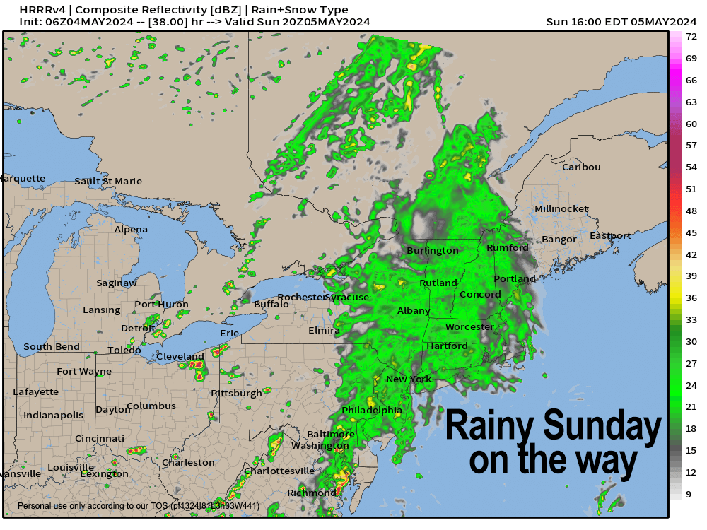
This will dim out our yellow-white starry orb by later this afternoon, thicken the cloud deck tonight, and serve as the harbinger of a widespread rainfall for our Sunday.
Sunday may start off with scattered showers, but the rain shield should fill in by afternoon and evening, with mostly light to moderate rains of the more gentle pitter-patter type.
It will cooler Sunday as well, so expect a fairly raw day, though I don’t expect much wind.
Showers exit by Monday morning, and a lovely, warming day develops with partly sunny skies (and a spot afternoon shower or t-storm), which tees us up for a killer early-summer type day on Tuesday with sunshine and some folks reaching 80º!
However, the mid to late week period does look unsettled as we have our departing upper ridge setting up over Atlantic Canada and being blocked from further eastward movement due to a system far to the east over the Atlantic Ocean.
Meanwhile, another upper low will press into the Great Lakes and sending pieces of energy and frontal boundaries at us, which could get blocked and held up over our region, producing several periods of showery weather.
I will get it all sorted out as we get closer in terms of more specifics on rain onset/departure etc., but temps should hang in the 60s for highs during this timeframe.
Hope you have a great day and rest of your weekend! Keep going!
>>> BE KIND <<<
“Hello babies. Welcome to Earth. It’s hot in the summer and cold in the winter. It’s round and wet and crowded. On the outside, babies, you’ve got a hundred years here. There’s only one rule that I know of, babies: Goddamn it, you’ve got to be kind.”
–Kurt Vonnegut
