~~~~~~~~~~~~~~~~~~~~~~
TABLE OF CONTENTS
* Daily Celestials (Sun/Moon Data)
* Weekly Weather Nutshell
* Morning Discussion
* TIP: Scroll below for sections, or read all
~~~~~~~~~~~~~~~~~~~~~~
YOUR DAILY CELESTIALS
~~~~~~~~~~~~~~~~~~~~~~
STAR:
–OUR STAR ROSE AT: 5:18am this morning
–OUR STAR SETS AT: 8:17pm this evening
–TOTAL DAYLIGHT TIME: 14 hours and 59 minutes
MOON:
–OUR MOON SETS AT: 9:50am this morning
–MOON SET DIRECTION: West-Southwest
–OUR MOON RISES AT: 1:05am tomorrow morning
–MOON RISE DIRECTION: East-Southeast
–MOON PHASE: Waning Gibbous (74.7%)
~~~~~~~~~~~~~~~~~~~~~~
A NOTE FROM OUR SPONSOR
~~~~~~~~~~~~~~~~~~~~~~
Dave Hayes The Weather Nut is Sponsored by Individual Community Members, Patrons, and Tandem Bagel Company… No matter the weather, Tandem Bagel is always there for you at several valley locations to make your mornings brighter! With *New Pizza Bagels(!)*, along with bagels baked fresh daily (including Gluten-Free options), house-whipped cream cheese, coffee, and tons of lunch options, Tandem is the perfect quick stop for lunch, breakfast, or a coffee and bagel to go.
You can either A) visit them in Easthampton, Northampton, Hadley, Florence, and/or West Springfield, B) hire them to cater your next event, or C) use their super-streamlined online ordering tool by visiting their website and clicking the “Catering” or “Order Online” links at https://www.tandembagelco.com
~~~~~~~~~~~~~~~~~~~~~~
YOUR WEEKLY WEATHER NUTSHELL
~~~~~~~~~~~~~~~~~~~~~~
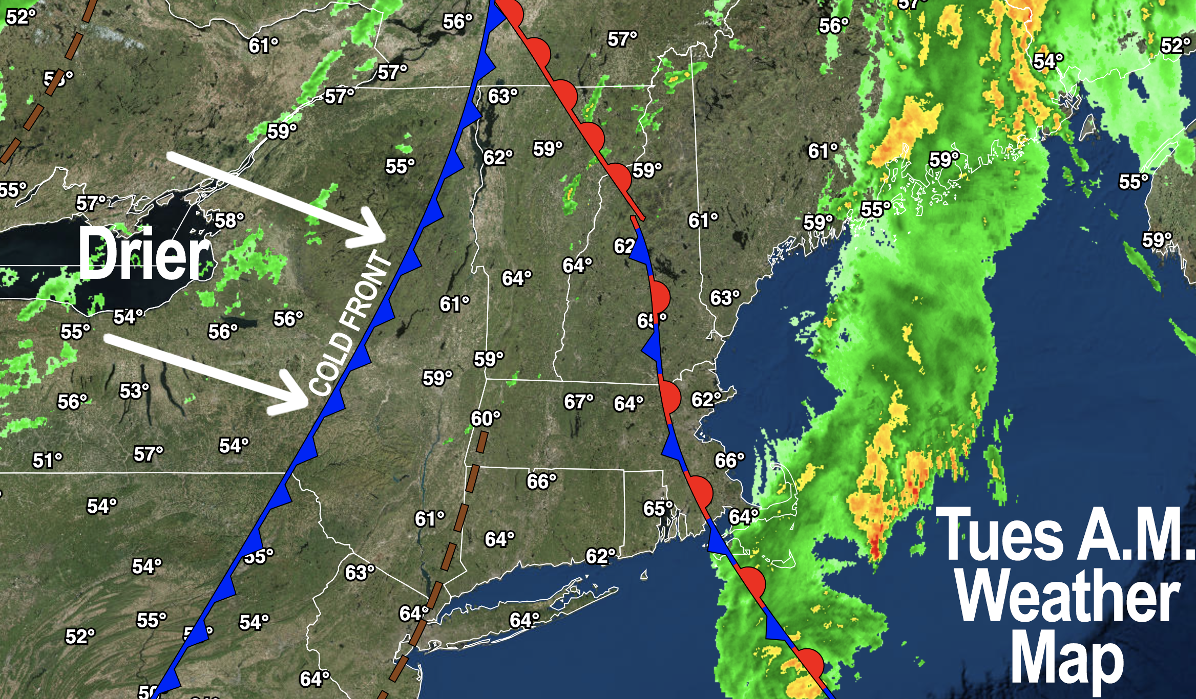
–A secondary cold front moves through the region today
–This will help develop partly sunny skies, which is already beginning this morning
–Highs reach the mid 70s to low 80s
–Humidity will drop through the day with dewpoints in the 60s early, decreasing into the 50s by this afternoon/eve
–An isolated shower will be seen by some, other stay dry
–Lows tonight will drop to the low to mid 50s
–By Wednesday, a weak wave will be tracking along the southeast edge of building high pressure over the Great Lakes, heading in New England’s direction
–Northwest flow will keep us cooler, with highs in the upper 60s to mid 70s, with more clouds than sun
–Scattered showers or a thunderstorm are expected for some by afternoon and evening, with lows down in the low 50s
–Shower chances increase into Thursday, with highs in the mid 60s to low 70s under mostly cloudy skies with chilly lows in the 45-50º range as our system tracks south of us and out to sea
–By Friday, high pressure will be increasing its grip on our region as it tracks southeast, headed for the Mid-Atlantic coast over the weekend
–Sunshine should dominate our skies for Friday through the weekend and into early next week, with warming temps
–Highs Friday will super pleasant, in the upper 60s to mid 70s, so I *highly* advise you get outside if you can!
–Now, if you’re a summah lovah, this weekend, as of now, looks KILLER, with sunshine and highs in the mid 70s to low 80s Saturday, and upper 70s to mid 80s on Sunday!
–Warm temps in the 80s continues into early next week with no big storms on the horizon, and a shot at 90º by the middle of next week
~~~~~~~~~~~~~~~~~~~~~~
YOUR MORNING DISCUSSION
~~~~~~~~~~~~~~~~~~~~~~
Good morning everybody, some of us got quite the soaking yesterday into the evening, many with a half inch to 1.5″ of rain, and some over 2″!
It sure seems like water table has come up over recent years, because the street flooding seems easier to achieve these days, and some of us along the CT River Valley sure got drenched early yesterday, before the more stratiform rainfall of late afternoon and evening breezily swept through the region.
As for our significant rainfall chances, we just experienced it as I don’t see any similarly-sized rain events for at least a week if not longer.
We will see a weaker, smaller system track near our region (likely just south) Wednesday P.M. into Thursday that will bring a renewed chance of some rainfall, but I’d be impressed if we saw over half an inch in general (though anyone in a localized area under an isolated thunderstorm could go over that amount).
The bottom line is that we are drying today with a few showers possible or a t-storm later, with partly sunny skies developing as humidity lowers behind our passing cold front.
We see clouds slowly increase Wednesday, and get into a scattered shower period Wednesday night into Thursday, which will be followed by ginormous high pressure building southeast out of the Great Lakes by late week.
This at first brings cooler northwest flow for Friday, which for me is going to be the pick of the month of May (just in time!), with low to mid 70s highs and plenty of sun.
Then we warm through the weekend and into early next week with plenty of sunshine as the first day of meteorological summer arrives on Saturday.
Timely, indeed.
Have a great day!
>>> BE KIND <<<
“Hello babies. Welcome to Earth. It’s hot in the summer and cold in the winter. It’s round and wet and crowded. On the outside, babies, you’ve got a hundred years here. There’s only one rule that I know of, babies: Goddamn it, you’ve got to be kind.”
–Kurt Vonnegut
