~~~~~~~~~~~~~~~~~~~~~~
TABLE OF CONTENTS
* Daily Celestials (Sun/Moon Data)
* Weekly Weather Nutshell
* Morning Discussion
* TIP: Scroll below for sections, or read all
~~~~~~~~~~~~~~~~~~~~~~
YOUR DAILY CELESTIALS
~~~~~~~~~~~~~~~~~~~~~~
STAR:
–OUR STAR ROSE AT: 5:19am this morning
–OUR STAR SETS AT: 8:16pm this evening
–TOTAL DAYLIGHT TIME: 14 hours and 57 minutes
MOON:
–OUR MOON SETS AT: 8:35am this morning
–MOON SET DIRECTION: Southwest
–OUR MOON RISES AT: 12:32am tomorrow evening
–MOON RISE DIRECTION: East-Southeast
–MOON PHASE: Waning Gibbous (83.6%)
~~~~~~~~~~~~~~~~~~~~~~
A NOTE FROM OUR SPONSOR
~~~~~~~~~~~~~~~~~~~~~~
Dave Hayes The Weather Nut is Sponsored by Individual Community Members, Patrons, and Tandem Bagel Company… No matter the weather, Tandem Bagel is always there for you at several valley locations to make your mornings brighter! With *New Pizza Bagels(!)*, along with bagels baked fresh daily (including Gluten-Free options), house-whipped cream cheese, coffee, and tons of lunch options, Tandem is the perfect quick stop for lunch, breakfast, or a coffee and bagel to go.
You can either A) visit them in Easthampton, Northampton, Hadley, Florence, and/or West Springfield, B) hire them to cater your next event, or C) use their super-streamlined online ordering tool by visiting their website and clicking the “Catering” or “Order Online” links at https://www.tandembagelco.com
~~~~~~~~~~~~~~~~~~~~~~
YOUR WEEKLY WEATHER NUTSHELL
~~~~~~~~~~~~~~~~~~~~~~
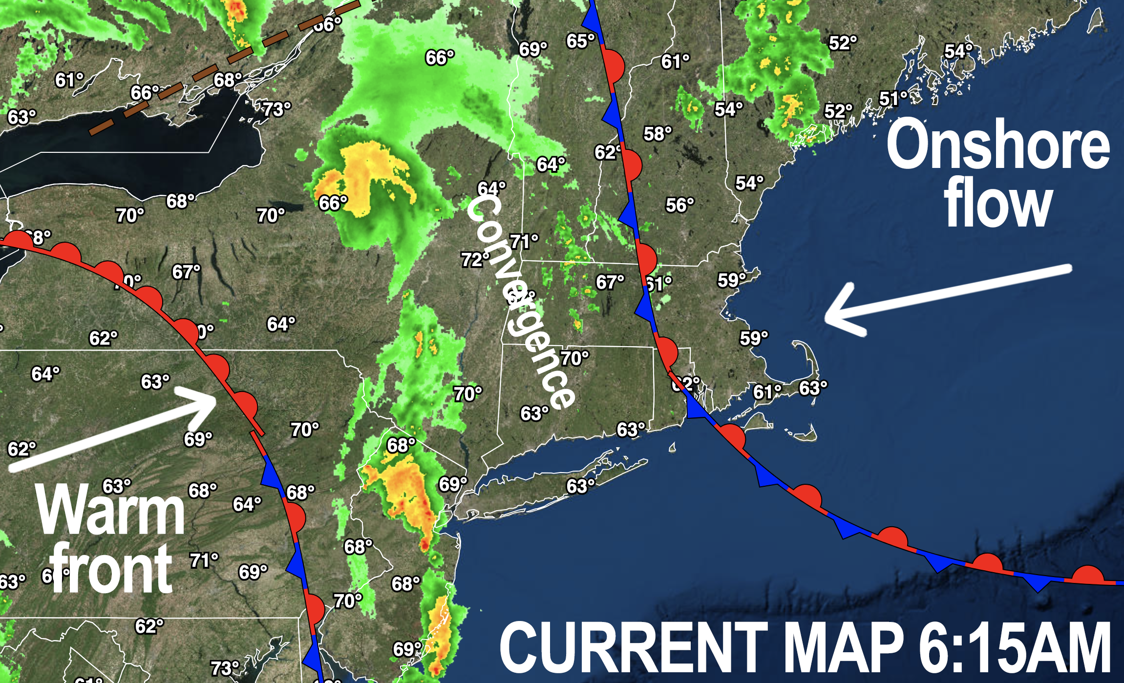
–Onshore flow from the east, and a warm front approaching from the southwest funnels humidity and moisture into the region today
–Scattered showers or even a thunderstorm or two are expected for some later this morning into the mid/late afternoon
–Highs reach the low to mid 70s with lows near 60º
–By late afternoon, a cold front will be sweeping northeast towards our region
–This will help enhance converging air over our region, and produce rainfall heavy at times this evening and ending around midnight or into the pre-dawn hours
–Downpours are expected with some street flooding possible
–Some thunderstorms may become strong to severe with damaging wind possible
–While extremely low potential, I will be watching for any cloud rotation or spin
–By Tuesday morning, any remnant showers will be quickly exiting, which should lead to a mostly sunny day as the dry slot comes through
–Highs should climb into the 75-80º range with lows in the 50s
–Wednesday starts off dry, and will be cooler with highs upper 60s to mid 70s
–Any partial sun likely clouds over with a weak system lifting northeast from the Mid-Atlantic Ocean with some showers by Wednesday night into Thursday morninig
–Thursday looks cool with highs in the mid 60s to low 70s
–By Friday into the weekend, for now, it looks like fair and sunny weather is quite possible with high pressure building into the region
–Friday will have temps similar to Thursday, climbing well into the 70s for what will hopefully become a sunny weekend!
~~~~~~~~~~~~~~~~~~~~~~
YOUR MORNING DISCUSSION
~~~~~~~~~~~~~~~~~~~~~~
Good morning everybody, we’ve got a humid and for some wet morning underway, and while showers will be isolated early, they should slowly become more numerous, and/or longer lasting than some of the hit or miss ones overnight.
We do have a decaying line of overnight convection headed northeast through southeast NY and the lower Hudson Valley of eastern NY, so more rain or a rumble is on the way.
The main focus of this discussion is the 4pm-12am timeframe for this afternoon and tonight.
This is because we have a potent cold front coming through the region which will occlude (i.e. catch up to and overtake) the parent storm’s warm front which will get hung up around northern NJ and southeast NY.
As this happens it will be funneling increasingly moist air from south to north through the greater WMass region with onshore flow to our east.
This all combines to produce heavy rain this evening and tonight capable of producing some street flooding.
Today is one of those days with warm air higher up init he sky, that helps to produce rainfall more efficiently, such that you can see a little green blip on the radar and it’s raining pretty good just below it.
Yes, my grammar was pretty-good terrible in that last paragraph but I reserve the right to be the eastern MA knucklehead that I am at times!
So, the 4pm to midnight period is when we should see heavy rain moving into the region, with street flooding possible, along with some strong to even severe thunderstorms, mainly west of the I-91, if they do form.
We can’t rule out damaging straight line winds, but unless we get some clearing of the cloud deck over eastern NY by early to mid afternoon, I think the heavy rain threat will be our primary one.
Other than that, the Nutshell above handles the rest of the details with a nicer Tuesday on tap, some rain showers Wednesday into Thursday (timeframe to be refined by tomorow), with potential for a lovely late week / weekend look with sun and 70s!
Have a great day and I will update later!
>>> BE KIND <<<
“Hello babies. Welcome to Earth. It’s hot in the summer and cold in the winter. It’s round and wet and crowded. On the outside, babies, you’ve got a hundred years here. There’s only one rule that I know of, babies: Goddamn it, you’ve got to be kind.”
–Kurt Vonnegut
