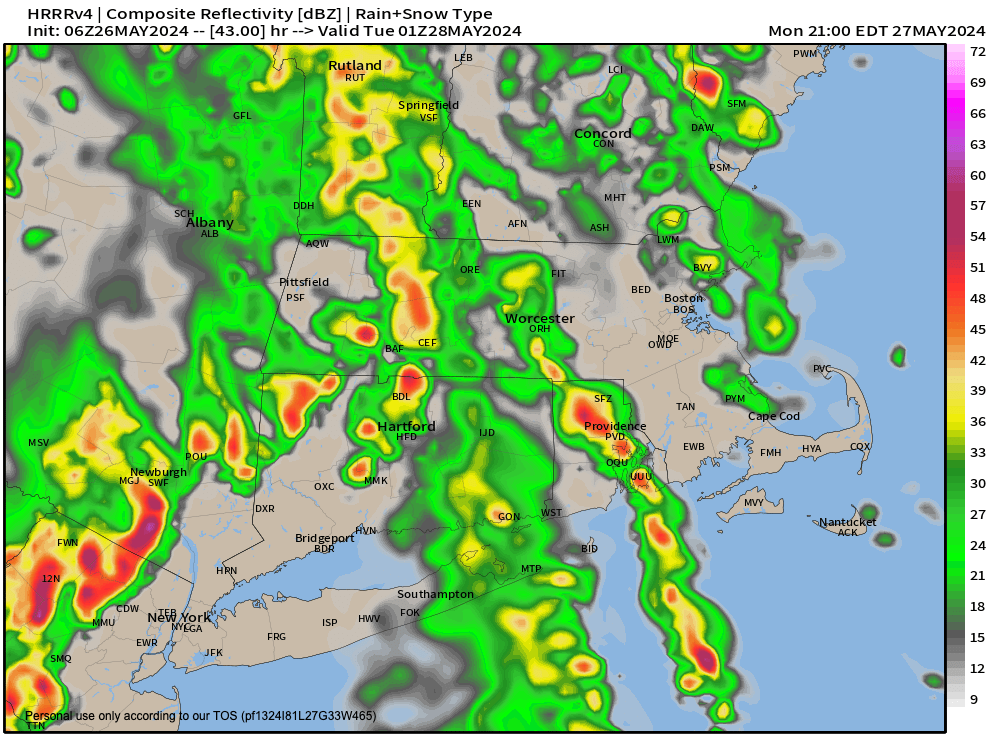
[8:08AM SUN: 5/26/24] THUNDERSTORMS POSSIBLE LATE TODAY AND THIS EVENING WITH SOME SCATTERED SHOWERS AFTER A PARLTY TO MOSTLY SUNNY START… MONDAY SHOULD START OFF SHOWERY, AND THEN MOVE INTO HEAVY RAINFALL AT TIMES BY THE EVENING INTO THE OVERNIGHT HOURS WITH THUNDER, AND POTENTIAL FOR STRONG TO SEVERE THUNDERSTORMS AND GUSTY WINDS… TUESDAY IS SWEPT DRY WITH WESTERLY WIND… A FEW MORE SHOWERS POSSIBLE BY WEDNESDAY AFTERNOON INTO THURSDAY… TEMPS COOL TOWARD LATE WEEK…

~~~~~~~~~~~~~~~~~~~~~~
TABLE OF CONTENTS
* Daily Celestials (Sun/Moon Data)
* Weekly Weather Nutshell
* Morning Discussion
* TIP: Scroll below for sections, or read all
~~~~~~~~~~~~~~~~~~~~~~
YOUR DAILY CELESTIALS
~~~~~~~~~~~~~~~~~~~~~~
STAR:
–OUR STAR ROSE AT: 5:20am this morning
–OUR STAR WILL SET AT: 8:15pm this evening
–TOTAL DAYLIGHT TIME: 14 hours and 55 minutes
MOON:
–OUR MOON WILL RISE AT: 11:51pm tonight
–MOON RISE DIRECTION: Southeast
–OUR MOON WILL SET AT: 8:35am tomorrow morning
–MOON SET DIRECTION: Southwest
–MOON PHASE: Waning Gibbous (90.6%)
~~~~~~~~~~~~~~~~~~~~~~
>>> A NOTE FROM OUR SPONSOR <<<
Dave Hayes The Weather Nut is Sponsored by Individual Community Members, Patrons, and Gerard, Ghazey & Bates, P.C. GGBPC is a Northampton-based law firm regarded as the voice of pragmatic and well-reasoned estate planning, elder law and tax guidance in Western Massachusetts. The firm specializes in estate planning law, and expertly handles other matters such as Elder Law, Tax Law, as well as Real Estate purchase, sales, and refinance transactions. Contact GGBPC today to see how they can help!
~~~~~~~~~~~~~~~~~~~~~~
YOUR WEEKLY WEATHER NUTSHELL
~~~~~~~~~~~~~~~~~~~~~~
–Overnight isolated showers have given way to some drying and sunshine with warm highs set to rise into the low to mid 80s
–A wave will move through to our north and bring a renewed chance for wet weather, with potential for some stronger thunderstorms late in the day, along with showers
–These should be pulse type storms, but one or two could produce hail or strond wind gusts
–Things become more stable after sunset, and lows drop to either side of 60º
–By Memorial Day, we’re going to see onshore flow meeting up with an incoming warm front from the west with increasing humidity
–This is going to set us up for shower development by morning, and lasting in intermittent fashion during the afternoon
–Highs will reach the upper 60s to mid 70s
–As an upper trough swings into the region, this upper level support, and convergence at the surface will produce heavy rain Monday night into the pre-dawn hours of Tuesday morning
–We could see some severe thunderstorms as well, and strong gusty winds may mix down in any heavy rain cells
–In addition, some rotation in the lower atmosphere will be present, so I can’t rule out a quick spin-up/weak tornado, so please stay tuned to upcoming forecasts and reports
–A dry slot will punch through the region Tuesday morning as the parent low pressure system tracks well north of us and pulls it’s cold front through
–Temps will be warm on Tuesday at first, hitting 80º as partly sunny skies develop, and we should then drop into the 50s at night
–The Wednesday through Friday period looks more seasonable in terms of seeing highs in the 70s, but by Friday we may drop into the 60s for highs with a cyclonic, northwesterly flow in place
–Despite a few showers, or a rainy period Wednesday night into Thursday, we should be dry most of the second half of the week into next weekend before more showers are possible next Sunday
~~~~~~~~~~~~~~~~~~~~~~
YOUR MORNING DISCUSSION
~~~~~~~~~~~~~~~~~~~~~~
Good morning folks, well, I’ve got the earliest load-in and sound check of my life today at the Iron Horse, at which I’ll be performing with the uber-talented Mister G for an 11am show.
As such, the Nutshell is going to handle the load this morning (I kind of discuss the weather deets in there as it is), but the main point I want to make other than to say watch for some scattered showers and thunderstorms later this afternoon, is that Monday looks WET and Monday later afternoon and especially during the overnight period could produce HEAVY rainfall, strong to severe thunderstorms, and a potential for some rotation with a VERY LOW chance for a tornado.
We’ve got this one-two punch of onshore flow combining with incoming moisture from the southwest to foster heavy rainfall capable of street flooding, and sweeping from southwest to northwest a frontal boundary which will funnel strong moisture into our region with strong wind in the lower-mid levels.
In these setups, we always have to watch for little rotational areas embedded in any storms that do form.
I will be all over it, and update you as often as possible. Have a great day!
>>> BE KIND <<<
“Hello babies. Welcome to Earth. It’s hot in the summer and cold in the winter. It’s round and wet and crowded. On the outside, babies, you’ve got a hundred years here. There’s only one rule that I know of, babies: Goddamn it, you’ve got to be kind.”
–Kurt Vonnegut
