~~~~~~~~~~~~~~~~~~~~~~
TABLE OF CONTENTS
* Daily Celestials (Sun/Moon Data)
* Weekly Weather Nutshell
* Morning Discussion
* TIP: Scroll below for sections, or read all
~~~~~~~~~~~~~~~~~~~~~~
YOUR DAILY CELESTIALS
~~~~~~~~~~~~~~~~~~~~~~
STAR:
–OUR STAR ROSE AT: 5:20am this morning
–OUR STAR WILL SET AT: 8:14pm this evening
–TOTAL DAYLIGHT TIME: 14 hours and 54 minutes
MOON:
–OUR MOON WILL RISE AT: 10:59pm tonight
–MOON RISE DIRECTION: Southeast
–OUR MOON WILL SET AT: 7:26am tomorrow morning
–MOON SET DIRECTION: Southwest
–MOON PHASE: Waxing Gibbous (95.9%)
~~~~~~~~~~~~~~~~~~~~~~
>>> A NOTE FROM OUR SPONSOR <<<
Dave Hayes The Weather Nut is Sponsored by Individual Community Members, Patrons, and Gerard, Ghazey & Bates, P.C. GGBPC is a Northampton-based law firm regarded as the voice of pragmatic and well-reasoned estate planning, elder law and tax guidance in Western Massachusetts. The firm specializes in estate planning law, and expertly handles other matters such as Elder Law, Tax Law, as well as Real Estate purchase, sales, and refinance transactions. Contact GGBPC today to see how they can help!
~~~~~~~~~~~~~~~~~~~~~~
YOUR WEEKLY WEATHER NUTSHELL
~~~~~~~~~~~~~~~~~~~~~~
–A gorgeous day to kick off the weekend with highs in the upper 70s to low 80s, with a few mid 80s possible, and dry and sunny!
–Lows tonight will fall toward the upper 50s with clouds increasing as our northwest flow backs to southwest
–With a weak low tracking north of us, moisture increases, and some showers or a rumble of thunder is possible overnight, especially west of the I-91 corridor
–For Sunday, a mixed day is expected, warm, with highs in the upper 70s to mid 80s, and some scattered showers or a thunderstorm with a mix of sun and clouds
–A few showers will be possible at night as well, with lows near 60º
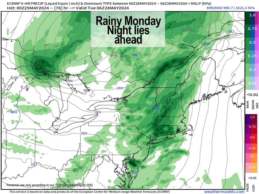
–By Monday, our weather goes down hill with a storm cranking up over the western Great Lakes
–This will send a pair of mid-level troughs toward our region, along with a surface-based cold front that will seep the region late Monday night into very early Tuesday morning
–So while the first part of the day may be dry and cloudy, showers will increase later Monday afternoon, and should become widespread at night, with potential for gusty winds
–Highs on Monday will only reach the upper 60s to mid 70s which is quite seasonable, but substantially less than the above average temps we’ve seen recently
–Monday night looks quite storm as of now, and I will update you the long weekend as to how that looks to develop as we get closer
–A dry slot punches in behind the cold frontal passage, and so after a showery Tuesday morning, we should turn out a nice day with sunshine breaking out
–The cold frontal passage will effectively knock as back down into seasonable temperature levels through the end of next week, mostly in the upper 60s to mid 70s range
–The Wednesday through Friday timeframe looks a bit unsettled with potential for more showers at times, but I’ll get it refined for you as we get closer
~~~~~~~~~~~~~~~~~~~~~~
YOUR MORNING DISCUSSION
~~~~~~~~~~~~~~~~~~~~~~
Good morning folks, today is going to be full-sun glorious!! Get out and enjoy it if you can, as tomorrow will be more of a mixed sky day with some showers scattered about (we could see some late tonight, too).
Monday into Tuesday is our stormy period with potential for heavy rain at times, totaling between 1-2″ by Tuesday morning, and a few thunderstorms can’t be ruled out, nor can a period of windy conditions overnight Monday into very early Tuesday.
Cooler and drier air should punch into the region by mid-day Tuesday, and should turn out a nice day.
However, by mid-week there are signs of more unsettled conditions with another storm potentially pushing through our region by Thursday with more rainfall, with temps generally in the low to mid 70s Tuesday through Friday, for a more seasonable, late-Spring feel.
Lastly, if you have kids and have been wanting to get to the newly-opened Iron Horse, grab the family and head out to Northampton tomorrow morning as I am performing live with the amazingly talented songwriter, musician, and author Mister G, along with Jon Carroll keys/accordion, and J.J. O’Connell on drums from 11am-Noon to help raise money for the Horse, which is a venue I first played live at 30 years ago, and one we all hope will remain open for at least another 30+ more!
Hope to see you there and have a great day!
P.S. I am taking tomorrow off, I need to get some sleep, which has been eluding me lately.
>>> BE KIND <<<
“Hello babies. Welcome to Earth. It’s hot in the summer and cold in the winter. It’s round and wet and crowded. On the outside, babies, you’ve got a hundred years here. There’s only one rule that I know of, babies: Goddamn it, you’ve got to be kind.”
–Kurt Vonnegut
