Good morning everybody, last night we celebrated the life and amazing talents, personality, and chutzpah of the amazing Kate Lorenz at the Shea Theatre in Turners, and the music flowed abundantly. I had the good fortune of playing music with Kate once (though I wish it was a lot more). She was a burning-bright soul, and everyone that knew her or loved her was made a much better person because of it.
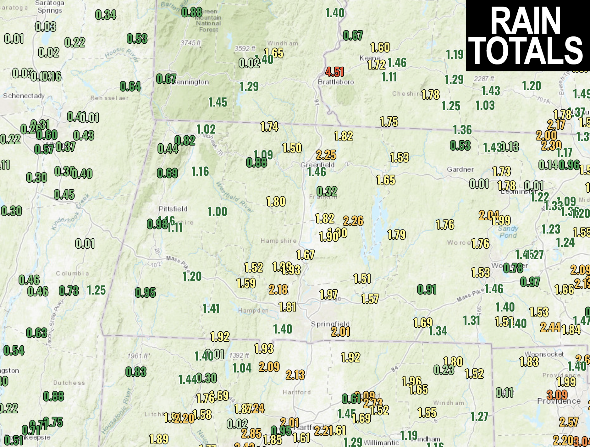
As for our weather, we got a solid drink yesterday and it mostly played out the way I was expecting, which is always nice. A solid 1-2.5″ range of rain totals fell from about the eastern Berkshires eastward with less than an inch in spots north and west of there.
Fair weather will follow today through mid-week as temps warm before a cold front swings through the region Wednesday night with some showers, which will also cool us down. The big concern for outdoor plans is the Memorial Day Weekend, which is starting to look pretty stormy and cool, but before we jump into the weather and daily details below, let’s check a note from our new weekend sponsor, #RedFireFarm located in Granby, MA.
~~~~~~~~~~~~~~~~~~~~~~
A NOTE FROM OUR WEEKEND SPONSOR:
Dave Hayes The Weather Nut is Sponsored by Individual Community Members, Patrons & Red Fire Farm. The Red Fire Farm store is open daily at 7 Carver Street in Granby, MA, and if you are looking for delicious organic produce, join their Summer CSA farm share. Vibrant greens, luscious heirloom tomatoes, sweet carrots and lots more to enjoy. Shares get free Pick Your Own, kicking off with strawberries in June. Add pastured eggs, local fruit & cheeses, mushrooms, pantry items, bouquets of organic flowers, and more. Weekly pickups at the Granby farm, Montague, Amherst, Forest Park/Springfield, Northampton, & Worcester (plus home delivery available), so click here today and snag your Summer Share!
~~~~~~~~~~~~~~~~~~~~~~~~~~~~~~~~
WEATHER REPORT
I imagine all flora are delighted with yesterday’s rainfall, as it fell over a decent period though I definitely know there was some street flooding, and in some cases it might have been too much too quick in spots.
As for today, a partly sunny day is expected, and we’ll warm into the mid 60s to low 70s with more sunshine in the afternoon. Lows tonight will drop into the 40s.
Then we will warm gradually through Wednesday with highs low to mid 70s Tuesday with some upper 60s in the high terrain, and then well into the 70s for Wednesday with lows in the 40s both nights with plenty of sun in the day, and mostly clear skies at night.
Clouds will build Wednesday afternoon as a cold front swings toward the region, and passes through Wednesday night, bringing some scattered showers.
The cooler air by late week will result in highs mostly in the 60s to near 70º under mostly sunny skies.
However, by the weekend, we may see another coastal low develop and get captured by an upper trough which could keep showery weather around the region throughout part or most of the holiday weekend.
Details are still quite murky, but please stay tuned for updates, and I will see you here by 7am tomorrow morning with the week ahead outlook.
Have a great day!
BE KIND
“Hello babies. Welcome to Earth. It’s hot in the summer and cold in the winter. It’s round and wet and crowded. On the outside, babies, you’ve got a hundred years here. There’s only one rule that I know of, babies: Goddamn it, you’ve got to be kind.”
–Kurt Vonnegut
