~~~~~~~~~~~~~~~~~~~~~~
TABLE OF CONTENTS
* Daily Celestials (Sun/Moon Data)
* Weekly Weather Nutshell
* Morning Discussion
* TIP: Scroll below for sections, or read all
~~~~~~~~~~~~~~~~~~~~~~
YOUR DAILY CELESTIALS
~~~~~~~~~~~~~~~~~~~~~~
STAR:
–OUR STAR ROSE AT: 5:28am this morning
–OUR STAR SETS AT: 8:05pm this evening
–TOTAL DAYLIGHT TIME: 14 hours and 37 minutes
MOON:
–OUR MOON RISES AT: 1:22pm this afternoon
–MOON RISE DIRECTION: East-Northeast
–OUR MOON SETS AT: 2:49am tomorrow morning
–MOON SET DIRECTION: West
–MOON PHASE: Waxing Gibbous (58.7%)
~~~~~~~~~~~~~~~~~~~~~~
A NOTE FROM OUR SPONSOR
~~~~~~~~~~~~~~~~~~~~~~
Dave Hayes The Weather Nut is Sponsored by Individual Community Members, Patrons, and Tandem Bagel Company… No matter the weather, Tandem Bagel is always there for you at several valley locations to make your mornings brighter! With *New Pizza Bagels(!)*, along with bagels baked fresh daily (including Gluten-Free options), house-whipped cream cheese, coffee, and tons of lunch options, Tandem is the perfect quick stop for lunch, breakfast, or a coffee and bagel to go.
You can either A) visit them in Easthampton, Northampton, Hadley, Florence, and/or West Springfield, B) hire them to cater your next event, or C) use their super-streamlined online ordering tool by visiting their website and clicking the “Catering” or “Order Online” links.
~~~~~~~~~~~~~~~~~~~~~~
YOUR WEEKLY WEATHER NUTSHELL
~~~~~~~~~~~~~~~~~~~~~~
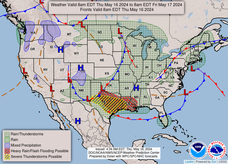
–While rain was expected and telegraphed for this morning into afternoon, a bit of a nor’easter has kicked up
–Our storm deepened a bit more and now sits south of mid-Long Island and east of central NJ
–This has helped to develop northeasterly wind gusts of 20-30mph, as well as steadier rainfall overnight, with some areas over an inch received
–Rain and showers will continue this morning, steadiest along and east of the CT River, but the precip shield is starting to break up, so some lulls will occur, too
–Heaviest rain will occur south of the Pike into northeast CT where some street flooding is possible
–Highs will only reach the upper 50s to mid 60s today
–Rain and wind taper off by mid to late afternoon, and we should begin to dry out
–Lows tonight will dip to near 50º with a light east wind
–Starting on Friday, we’ll see a upper level ridging (which promotes fair weather) develop to our northeast and nose down through New England
–Partly sunny skies should develop with highs in the low to mid 70s with lows in the low 50s for a lovely day/night combo
–As we move into the weekend, an upper low will track eastward to the southern Mid-Atlantic coast
–That low center should be shunted south of our region over the weekend by this upper level ridging
–That means that while Saturday likely features more clouds than sun due to the Mid-Atlantic low passing south of us, we should remain dry this weekend
–So, this is good news! Highs look to hit either side of 70º both days with lows near 50º, and more clouds on Saturday, and more sun on Sunday
–But wait, there’s more!
–Early to mid week now looks lovely with plenty of sunshine and WARM temps reaching the mid 70s to low 80s Monday thru Wednesday, and lows in the 50s thanks to high pressure developing to our south
–Some showers are possible by later Wednesday into Thursday with a frontal passage, but it shouldn’t amount to much
~~~~~~~~~~~~~~~~~~~~~~
YOUR MORNING DISCUSSION
~~~~~~~~~~~~~~~~~~~~~~
Good morning everybody, we’ve got one last day of breezy, rainy, cooler weather with our nor’easter parked south of Long Island, before it weakens and drops south, southeast and away from us #ForeverAndEver.
Rain and wind tapers off this afternoon, and certainly by this evening, after highs only reaching the upper 50s to mid 60s dropping to lows near 50º.
I like to group the weather pattern into chunks of roughly similar conditions and/or impacts, and boy oh boy, do we a spate, a plethora, a cornucopia, and an abundance of drier, sunnier, and warmer weather on the way after today.
I know, I know, it’s New England, stuff changes, but as of right now, once we get through today, I think we really dive into deeper Spring conditions.
The Nutshell above contains all of the divulgent details, but suffice it to say that tomorrow will way nicer than today with highs in the low to mid 70s under partly sunny skies.
The weekend continues to trend drier, and while a spot shower can’t be ruled out for Saturday south of the Pike, our mostly cloudy Saturday should mostly (if not entirely) dry, leading to a sunnier Sunday with highs either side of 70º as a low stays well south of us.
Next week looks even warmer with a real shot at low 80s for more than just one day as sunshine increases, with only a minor shower threat for Wed/Thurs as another frontal boundary approaches the region.
Hang in there with what looks like the 2024 cold season’s final goodbye, and have a great day!
>>> BE KIND <<<
“Hello babies. Welcome to Earth. It’s hot in the summer and cold in the winter. It’s round and wet and crowded. On the outside, babies, you’ve got a hundred years here. There’s only one rule that I know of, babies: Goddamn it, you’ve got to be kind.”
–Kurt Vonnegut
