
TODAY’S NUTSHELL: Our surface low is located over Cape Cod this morning and setting sail for the Gulf of Maine and Atlantic Canada, but not before one last parting shot of chilly rain with patchy fog this morning, ending by mid-day. It becomes gusty this afternoon with partial sunshine and clearing tonight. Sunday through Tuesday become the pick of the month with warming temps and sunshine. We stay warm mid to late week, but some showery periods are possible with increasing humidity.
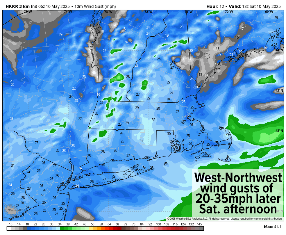
TABLE OF CONTENTS
* Daily Celestials (Sun/Moon Data)
* Sponsor Section
* Your Short-Term ZoneCast
* Morning Discussion
~~~~~~~~~~~~~~~~~~~~~~
YOUR DAILY CELESTIALS
~~~~~~~~~~~~~~~~~~~~~~
STAR:
–OUR STAR ROSE AT: 5:34am this morning
–OUR STAR SETS AT: 7:59pm this evening
–TOTAL DAYLIGHT TIME: 14 hours and 25 minutes
MOON:
–OUR MOON RISES AT: 6:21pm this afternoon
–MOON RISE DIRECTION: East-Southeast
–OUR MOON SETS AT: 4:40am tomorrow morning
–MOON SET DIRECTION: West-Southwest
–MOON PHASE: Waxing Gibbous (95.5%)
~~~~~~~~~~~~~~~~~~~~~~
>>> A NOTE FROM OUR WEEKEND SPONSOR <<<
Dave Hayes The Weather Nut is Sponsored by Individual Community Members, Patrons, and Gerard, Ghazey & Bates, P.C.
GGBPC is a Northampton-based law firm and is the area’s premier estate and tax planning provider. The firm specializes in Estate Planning, Elder Law, and Tax Law, so be sure to contact GGBPC today to see how they can help you.
Simply click the following link to their secure website.
~~~~~~~~~~~~~~~~~~~~~~
YOUR SHORT-TERM ZONECAST
~~~~~~~~~~~~~~~~~~~~~~
ZONE 1 – Northern Region
(Southern VT, Southwest NH)
–Highs Today: Mid 50s to Low 60s
–Lows Tonight: Low to Mid 40s
–Highs Tomorrow: Low to Mid 60s
–Winds: Northwest winds gust 20-35mph today, slackening tonight and tomorrow
–Skies: Overcast this morning, with partial clearing this afternoon
–Precip: Rain this morning, ending by mid day, dry tonight/tomorrow
–NWS Alerts + Nut Notes: Flood Warning for southwest NH for street flooding and isolated flash flooding
ZONE 2 – Central Region
(Western MA, North-Central MA, Northern Litchfield CT)
–Highs Today: Upper 50s to Mid 60s
–Lows Tonight: Low to Mid 40s
–Highs Tomorrow: Low to Upper 60s
–Winds: Northwest winds gust 20-35mph today, slackening tonight and tomorrow
–Skies: Overcast this morning, with partial clearing this afternoon
–Precip: Rain this morning, ending by mid-day, dry tonight/tomorrow
–NWS Alerts + Nut Notes: Flood Watch is up for the CT River at Northampton which may go into minor flood by tomorrow
ZONE 3 – Southern Region
(South-Central MA, Northern CT)
–Highs Today: Mid to Upper 60s
–Lows Tonight: Mid to Upper 40s
–Highs Tomorrow: Mid to Upper 60s
–Winds: Northwest winds gust 20-35mph today, slackening tonight and tomorrow
–Skies: Overcast this morning, with partial clearing this afternoon
–Precip: Scattered showers this morning, ending by late morning, dry tonight/tomorrow
–NWS Alerts + Nut Notes: Flood Watch is up for the CT River at Thompsonville which may go into minor flood by tomorrow. Flood Warning continues at Hartford.
~~~~~~~~~~~~~~~~~~~~~~
YOUR MORNING DISCUSSION
~~~~~~~~~~~~~~~~~~~~~~
Good morning folks, we’ve got a chilly start in the 40s to begin our final hours of dreary slog sogginess that have prevailed since last weekend when all hell broke loose in eastern Hampden County, southeast Hampshire County and southwest Worcester County.
For today, our upper low is over the eastern tip of Long Island and it is sweeping our surface low (now located over Cape Cod) seaward and into the Gulf of Maine later today.
We’re dealing with the final wraparound bands of rain and showers in our region this morning, the heaviest of which is east of the CT River Valley in eastern Franklin, Hampshire and Hampden Counties into Worcester County (and also in southeast VT and southwest NH), already ending in the Berkshires (MA), Litchfields (CT) and Bennington County (VT).
As the storm pulls east, the rain shield will do the same toward mid-day, and by 1pm or so final showers should be east of CMass and northeast CT, and partial sun will likely be developing west of I-91.
In addition, as the storm pulls away, and high pressure starts to build southeastward, northwest winds will pick up and gust 20-35mph this afternoon and evening, before slackening overnight into Sunday.
Highs today will reach the upper 50s to 60s for most of us as we get some sunshine to break out later this afternoon, and lows will dip into the 40s overnight as clear out our skies.
Once we reach tomorrow / Sunday, we’ve got a nice and needed 3-day sunny stretch with highs well into the 60s tomorrow (lows in the upper 30s to 40s, chilly!), then rising up and into the low to mid 70s for Monday and Tuesday. Lows Monday night dip into the low 50s, and then the mid 50s Tuesday night.
Tuesday may feature more of a partly sunny day, but it will still very pleasant, so that’s something to look forward to!
By mid to late week, we become a bit unsettled, but no washouts are expected, and temps should remain warm with increasing humidity.
For now, just expect some scattered showers at times, and I will refine it as we get closer to that time period.
Rain, you’re on the bench….. Sun, suit up!
Have a great day!
“Follow your bliss and the Universe will open doors for you where there were only walls.”
― Joseph Campbell