
MY MISSION
–> My Mission is to deliver hyper-local, timely and educational weather reports with humility, humor, and gratitude to help protect life and property for members of this community and region. With your help, I can work hard in 2023 toward that effort.
–> SecureSupportClick
——————-
TABLE OF CONTENTS:
–DHTWN Reminder (Be Nice)
–Weekly Nutshell (Quick impact list)
–Sponsor Note (Tandem Bagel Co.)
–NWS Alerts (Advisories, Warnings, Watches)
–Celestial Data (Sun/Moon info)
–Regional Summaries (Quick in/out details)
–Morning Discussion (More Details)
~~~~~~~~~~~~~~~~~~~~~~
DHTWN REMINDER: It doesn’t take much to do a nice thing for somebody that you don’t know.
~~~~~~~~~~~~~~~~~~~~~~
DAVE’S WEEKLY WEATHER NUTSHELL
–One final day under the influence of drunken Canadian low pressure slow to leave, but he gets the boot by tonight
–As such, we’re mostly cloudy today with seasonable highs in the upper 30s to mid 40s, flurry/sprinkle possible
–Light north wind up to 20mph this morning tamps down by tonight
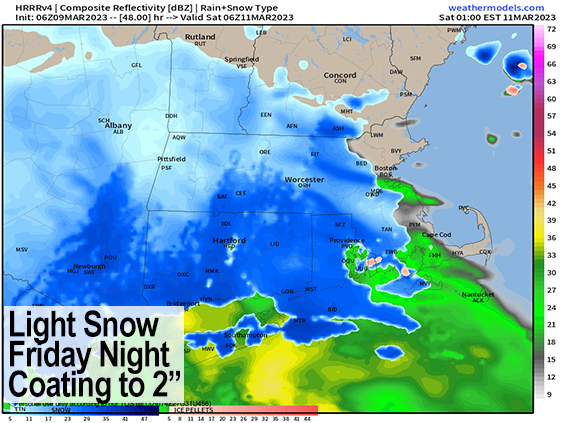
–Friday morning looks nice with partial sunshine, then clouds increase as a storm moves into PA, and tracks well south of us Friday night
–Periods of light snow move into the WMass and northwest CT with more scattered activity north of the MA line
–A coating to 2″ is possible by Saturday morning, with the most in Litchfield County (can’t rule out up to 3″ there)
–Saturday dries out with a very cold Saturday night, followed by a mild and truly sunny Sunday
–Clouds build Monday morning, and then we watch upcoming data and trends, as a powerful coastal nor’easter may visit us Monday afternoon, night and into Tuesday
–Way too early to talk about amounts, or rain/snow lines, but this storm looks windy, and some folks could see blizzard conditions, but before we jump into the weather discussion/details below, let’s check a note from our local and delicious sponsor, #TandemBagelCo, with their newest location in West Springfield, MA.
~~~~~~~~~~~~~~~~~~~~~~
A NOTE FROM OUR SPONSOR:
Dave Hayes The Weather Nut is Sponsored by Individual Community Members, Patrons & Tandem Bagel Company… No matter the weather, Tandem Bagel is always there for you at several valley locations to make your mornings brighter! With bagels baked fresh daily (including Gluten-Free options), house-whipped cream cheese, coffee, and tons of lunch options, Tandem is the perfect quick stop for lunch, breakfast, or a coffee and bagel to go. Find them in Easthampton, Northampton, Hadley, Florence, and West Springfield, or use their super-streamlined online ordering tool by visiting their website.
~~~~~~~~~~~~~~~~~~~~~~~~~~~~~~~~
***DHTWN DAILY WEATHER REPORT***
~~~~~~~~~~~~~~~~~~~~~~~~~~~~~~~~
NATIONAL WEATHER SERVICE ALERTS
–None
DAILY CELESTIAL (STAR):
–OUR STAR ROSE AT: 6:12am this morning
–OUR STAR WILL SET AT: 5:49pm this evening
–TOTAL DAYLIGHT TIME: 11 hours and 37 minutes
NIGHTLY CELESTIAL (MOON):
–OUR MOON WILL RISE AT: 8:09pm this evening
–OUR MOON WILL SET AT: 7:37am tomorrow morning
–MOON RISE DIRECTION: East
–MOON SET DIRECTION: West-Southwest
–MOON PHASE: Waning Gibbous (96.3%)
~~~~~~~~~~~~~~~~~~~~~~~~~~~~~~~~
DAILY TERRESTRIAL
ZONE 1 – Northern Region
(Southern VT, Southwest NH)
–High Temps: Mid to Upper 30s
–Low Temps: Low to Mid 20s
–Winds: Northerly winds gust up to 20mph this morning, slackens later
–Sky Cover: Mostly Cloudy, a few sunny breaks possible
–Precipitation: Isolated snow shower possible, otherwise dry
ZONE 2 – Central Region
(Western MA, North-Central MA, Northern Litchfield CT)
–High Temps: Upper 30s to Mid 40s
–Low Temps: Low to Mid 20s
–Winds: Northerly winds gust up to 20mph this morning, slackens later
–Sky Cover: Mostly Cloudy, a few sunny breaks possible
–Precipitation: Isolated snow shower possible, otherwise dry
ZONE 3 – Southern Region
(South-Central MA, Northern CT)
–High Temps: Mid 40s
–Low Temps: Mid to Upper 20s
–Winds: Northerly winds gust up to 20mph this morning, slackens later
–Sky Cover: Mostly Cloudy, a few sunny breaks possible
–Precipitation: Isolated snow shower possible, otherwise dry
~~~~~~~~~~~~~~~~~~~~~~~~~~~~~~~~
LET’S STAY CONNECTED
Visit this page on my website on Staying Connected
~~~~~~~~~~~~~~~~~~~~~~~~~~~~~~~~
MORNING DISCUSSION
Good morning everybody, our blocked-up, confused, slow-moving, ambling, wobbly, chilled out weather pattern courtesy of our old stacked/filled low pressure system near Nova Scotia is finally going to get the boot out to sea (think of the Italian peninsula facing the other way, and giving it a bit of a kick).
Still, we have one final day under its influence which will produce a mostly cloudy day, northerly gusts to 20mph this morning which will tamp down later, an isolated snow or rain shower possible, and highs in the upper 30s to mid 40s.
We may see a few peeks of sunshine, but clouds should rule the roost. For tonight, clouds will begin to break up into a partly cloudy sky with lows in the low to mid 20s with a touch of radiational cooling at work. Some areas in northern CT will only sit down into the upper 20s.
For Friday, the morning looks partly sunny with a bit of ridging moving through, but as the “weather queue” starts moving back through our region from west to east, so does a storm system press into Pennsylvania, which will then redevelop off of the Delaware coast and track just south of due east.
As it does so, clouds will increase on Friday with highs in the upper 30s to low 40s, and light snow will break out likely after sunset in northwest CT, the southern/central Taconics, and WMass, especially south of Rt. 2.
Periods of light snow are expected Friday night and breaking up by Saturday morning with a few leftover snow showers. Lows will drop into the upper 20s to low 30s.
This will be a light event that could have been much more impactful had our wobbly Atlantic Canadian low not suppressed more south like it’s expected to.
Anywhere from a coating to 2″ is possible, mainly south of the MA/VT-NH state line, with some snow showers in SVT and SWNH.
——————-
PLANTS THAT WE WATER KEEP FLOWERING
–> When 4% of readers “water” my work, I can keep going
–> I’m currently just 36% of the way to that goal
–> My 2023 Member Drive ends on 3/26, in 17 days
–> Anything helps: $10, $35 or $100+ one time, or smaller $3, $6, or $10 monthly
–> Click the secure link below to select from Membership or Support options
–> SecureCLICK
——————-
After snow showers quit Saturday morning, we’ll end up with a mostly cloudy day with highs in the mid to upper 30s, and lows in the upper teens to low 20s as colder works in behind our departing ocean storm, which will really deepen a lot out over the open waters.
Sunday is the pick of the weekend, and will be aptly named! Mostly sunny skies are expected with highs in the low to mid 40s, and lows in the mid to upper 20s with a light south wind.
Monday and Tuesday is the timeframe to watch at this point for a potentially potent Nor’easter, that at this range looks like it could produce blizzard conditions in parts of the region, though it’s RARE to get those kinds of conditions here, so I wouldn’t get worked up about it at this point.
The bottom line is that we should be clouding up on Monday depending on the storm track, and snow and potentially rain would work into the region by Monday afternoon and evening.
There is lots of guidance that shows deep low pressure centers south of RI and the Cape and Islands right where you want them to get a big March snowstorm.
There is NOT a lot of cold air available to tap for this system, but it could ber just cold enough to produce a heavy, wet snowstorm if all the ingredients come together, so please stay tuned for future updates in case these signals continue to trend and begin coalescing into a real storm impact.
Have a great day and if you rely on my interactive community weather reporting, you can support it at any level as a Member of my Support Nutwork or as a Supporter – it’s your Choice.
2023 MEMBER/SUPPORT DRIVE SECURE LINK
AND REMEMBER…
“Hello babies. Welcome to Earth. It’s hot in the summer and cold in the winter. It’s round and wet and crowded. On the outside, babies, you’ve got a hundred years here. There’s only one rule that I know of, babies: Goddamn it, you’ve got to be kind.”
–Kurt Vonnegut