GET A LOCAL FOCUS – You get a hyper-local and regionally relevant weather outlet supported by the community, for the community.
–> SecureClick
~~~~~~~~~~~~~~~~~~~~~~
TABLE OF CONTENTS
* Daily Celestials (Sun/Moon Data)
* Weekly Weather Nutshell
* Morning Discussion
* TIP: Scroll below for sections, or read all
~~~~~~~~~~~~~~~~~~~~~~
YOUR DAILY CELESTIALS
~~~~~~~~~~~~~~~~~~~~~~
STAR:
–OUR STAR ROSE AT: 6:13am this morning
–OUR STAR SETS AT: 5:49pm this evening
–TOTAL DAYLIGHT TIME: 11 hours and 36 minutes
MOON:
–OUR MOON SETS AT: 3:44pm this afternoon
–MOON SET DIRECTION: West-Southwest
–OUR MOON RISES AT: 6:03am tomorrow morning
–MOON RISE DIRECTION: East-Southeast
–MOON PHASE: Waning Crescent (5.5%)
~~~~~~~~~~~~~~~~~~~~~~
A NOTE FROM OUR SPONSOR
~~~~~~~~~~~~~~~~~~~~~~
Dave Hayes The Weather Nut is Sponsored by Individual Community Members, Patrons, and Tandem Bagel Company… No matter the weather, Tandem Bagel is always there for you at several valley locations to make your mornings brighter! With *New Pizza Bagels(!)*, along with bagels baked fresh daily (including Gluten-Free options), house-whipped cream cheese, coffee, and tons of lunch options, Tandem is the perfect quick stop for lunch, breakfast, or a coffee and bagel to go. Find them in Easthampton, Northampton, Hadley, Florence, and West Springfield, or use their super-streamlined online ordering tool by visiting their website.
~~~~~~~~~~~~~~~~~~~~~~
YOUR WEEKLY WEATHER NUTSHELL
~~~~~~~~~~~~~~~~~~~~~~
–Freezing dense fog in the northern Berkshires and southwest NH with temps in the 20s dissipates, but watch for slippery surfaces early
–High pressure builds in from the north, and bestows us with bountiful blue skies and sunshine with highs in the low to mid 50s today with a light east wind #ChefsKiss
–We’ll cool down into the 20s tonight as clouds start to filter in
–Saturday will see the cloud deck thicken as our southern stream storm system makes a run at New England
–Highs will reach the only into the mid to upper 40s for most of us
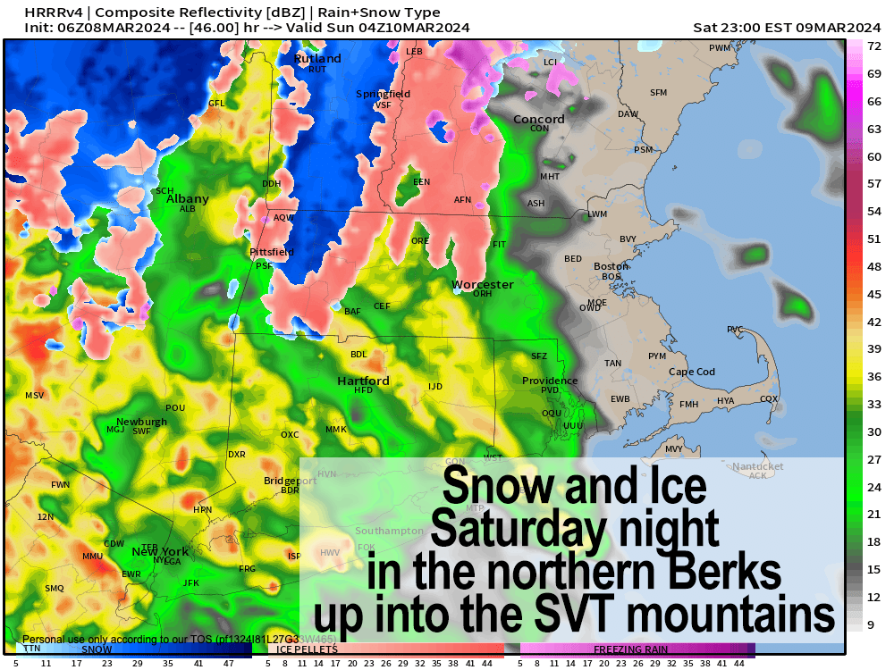
–It will be dry ahead of this next storm, and so when rain arrives between 4-8pm from southwest to northeast, evaporative cooling should result flipping parts of the northern Berkshires, northwest hilltowns and SVT over to sleet and/or snow
———————————–
Help underpin this community resource,
Any amount helps, even $5 or $2/month:
Click–> https://westernmassweather.com/support-network/
~~~~~~~~~~~~~~~~~~~~~~
–Some sleet or sleet/snow mix should form in northern CMass, eastern Franklin County up into SWNH
–Otherwise we will see rain across much of the greater WMass region, with a coating to 3″ of wet snow possible before it changes to rain in those high elevation areas
–Southeast winds will also ramp up and gust 25-40mph tomorrow night, but the valley most likely sees lower gusts due to an inversion, with high terrain areas getting those winds
–Precip rips out of here by early Sunday morning as our storm system runs through EMass and out toward Atlantic Canada
–Sunday starts off milder with highs 45-50º, but a cold front comes through and drops temps later in the afternoon turning some scattered rain showers into snow showers by night time
–Winds will gust out of the northwest 25-40mph at night and into Monday, with Sunday lows in the 20s, and Monday highs in the upper 30s to mid 40s with snow showers abating
–Tuesday through Friday looks sunnier and milder with no new storm activity until next week, so there’s light at the end of our recent stormy tunnel!
~~~~~~~~~~~~~~~~~~~~~~
YOUR MORNING DISCUSSION
~~~~~~~~~~~~~~~~~~~~~~
Good morning everybody, of note this morning is waning freezing fog in the northern Berkshires and southwest NH, and the continuance of Flood Warnings due to minor flooding now happening at Northampton and Hartford.
Northampton’s CT River flooding abates tonight slowly, and Hartford’s abates tomorrow, though I am worried that with another inch-plus of potential rainfall for Saturday night into Sunday morning, this may exacerbate this issue.
Honestly, I was quite surpriseed that the CT flooded, and either don’t fully understand the impact of upstream snow melt this year, or the river bed isn’t draining well, so I need to learn more about it.
As for our weather, today’s the day to get outside and enjoy life and our star for a minute, because a mostly cloudy weekend lies ahead, though some partial sunshine is possible Sunday afternoon behind the cold front.
The Nutshell covers the details well, but it’s basically sunny today, partly cloudy tonight, cloudy tomorrow, windy, snowy and rainy Saturday night into Sunday morning, a brief mild shot on Sunday before a cold front swings through with cooler temps, strong northwesterlies Sunday afternoon, night and into Monday with scattered rain and snow showers, and additional light accumulations possible in the Berkshires, hilltowns and SVT.
After that? Mild sunny days for much of next week, so we just need to get through this weekend’s storm and bluster before reaching a calmer set of conditions. We can do it!
Have a great day, and if my work helps you, please help keep it going throughout 2024… it’s your support that keeps me on this job for you and yours (options include Cards, PayPal, Venmo, or Check, thank you!)
———————————–
SECURELY BECOME A 2024 DHTWN SUPPORTER TODAY
~~~~~~~~~~~~~~~~~~~~~~
>>> BE KIND <<<
“Hello babies. Welcome to Earth. It’s hot in the summer and cold in the winter. It’s round and wet and crowded. On the outside, babies, you’ve got a hundred years here. There’s only one rule that I know of, babies: Goddamn it, you’ve got to be kind.”
–Kurt Vonnegut
