
Potential Monday night winter storm
–> My Mission is to deliver hyper-local, timely and educational weather reports with humility, humor, and gratitude to help protect life and property for members of this community and region.
–> My Intention is for you to feel informed, prepared, valued, thought of, looked after, entertained, and appreciated through my daily weather reporting.
–> My Belief is that if you depend on my work, you’ll want to help sustain it and will become a 2023 Member (with gifts) or Supporter (no stuff) at any level at this secure link.
——————-
TABLE OF CONTENTS:
–DHTWN Reminder (Be Nice)
–Weekly Nutshell (Quick impact list)
–Sponsor Note (Tandem Bagel Co.)
–NWS Alerts (Advisories, Warnings, Watches)
–Celestial Data (Sun/Moon info)
–Regional Summaries (Quick in/out details)
–Morning Discussion (More Details)
~~~~~~~~~~~~~~~~~~~~~~
DHTWN REMINDER: It doesn’t take much to do a nice thing for somebody that you don’t know.
~~~~~~~~~~~~~~~~~~~~~~
DAVE’S WEEKLY WEATHER NUTSHELL
–Today (Wed) and tomorrow (Thurs) are fairly similar copies to each other
–Mix of sun and clouds, though today is windier with northern gusts 15-30mph
–Isolated rain or snow showers can’t be ruled out each day
–Seasonable highs 35-40º both days, lows 20s
–Friday is sunnier, milder, low to mid 40s
–Saturday is mostly cloudy with some snow showers possible in northern CT with a storm shunted mostly south of us, will continue to monitor for any changes
–Sunday is the pick of the weekend with partly sunny skies
–Monday clouds up, and a bigger coastal storm may bring wintry impacts to the region Monday night into Tuesday, but before we jump into the weather discussion/details below, let’s check a note from our local and delicious sponsor, #TandemBagelCo, with their newest location in West Springfield, MA.
~~~~~~~~~~~~~~~~~~~~~~
A NOTE FROM OUR SPONSOR:
Dave Hayes The Weather Nut is Sponsored by Individual Community Members, Patrons & Tandem Bagel Company… No matter the weather, Tandem Bagel is always there for you at several valley locations to make your mornings brighter! With bagels baked fresh daily (including Gluten-Free options), house-whipped cream cheese, coffee, and tons of lunch options, Tandem is the perfect quick stop for lunch, breakfast, or a coffee and bagel to go. Find them in Easthampton, Northampton, Hadley, Florence, and West Springfield, or use their super-streamlined online ordering tool by visiting their website.
~~~~~~~~~~~~~~~~~~~~~~~~~~~~~~~~
***DHTWN DAILY WEATHER REPORT***
~~~~~~~~~~~~~~~~~~~~~~~~~~~~~~~~
NATIONAL WEATHER SERVICE ALERTS
–None
DAILY CELESTIAL (STAR):
–OUR STAR ROSE AT: 6:14am this morning
–OUR STAR WILL SET AT: 5:48pm this evening
–TOTAL DAYLIGHT TIME: 11 hours and 34 minutes
NIGHTLY CELESTIAL (MOON):
–OUR MOON WILL RISE AT: 7:05pm this evening
–OUR MOON WILL SET AT: 7:17am tomorrow morning
–MOON RISE DIRECTION: East
–MOON SET DIRECTION: West
–MOON PHASE: Waning Gibbous (99.1%)
~~~~~~~~~~~~~~~~~~~~~~~~~~~~~~~~
DAILY TERRESTRIAL
ZONE 1 – Northern Region
(Southern VT, Southwest NH)
–High Temps: Mid to Upper 30s
–Low Temps: Mid to Upper 20s
–Winds: Northerly winds gusting 15-30mph
–Sky Cover: Mixed sun and clouds
–Precipitation: Isolated snow shower possible, otherwise dry
ZONE 2 – Central Region
(Western MA, North-Central MA, Northern Litchfield CT)
–High Temps: Mid 30s to Low 40s
–Low Temps: Mid to Upper 20s
–Winds: Northerly winds gusting 15-30mph
–Sky Cover: Mixed sun and clouds, more sun in the valley
–Precipitation: Isolated snow shower possible, otherwise dry
ZONE 3 – Southern Region
(South-Central MA, Northern CT)
–High Temps: Low to Mid 40s
–Low Temps: Upper 20s to Low 30s
–Winds: Northerly winds gusting 15-30mph
–Sky Cover: Partly to Mostly Sunny
–Precipitation: Isolated snow shower possible, otherwise dry
~~~~~~~~~~~~~~~~~~~~~~~~~~~~~~~~
MORNING DISCUSSION
Good morning everybody, well we’re back, where we started! Here we go ’round again! Day after d, oh God, that Kinks song again, Dave? Just STAHHP!!!
Sorry, I’m a bit of a riff head and cycle around a small circle of songs that get me going in the morning, and that’s one of them! :-D
I hope you all slept well and didn’t have wackadoodle dreams like myself, I gotta stop drinking caffeine in the afternoon!
Anyway, we’ve got mostly fair weather through at least Friday, and at this rate and with these trends, right through the weekend as well before we face our next larger storm threat for Monday afternoon/night into Tuesday.
In the short-term, low pressure continues to wobble around Nova Scotia send lobes of energy round its westerly flank, tracking southwest towards us, then south through the region, and then southeast away through cyclonic counterclockwise motion.
This will bring a mix of sun and some clouds today, with in isolated snow or rain shower possible, especially east of the CT River into eastern SWNH, central MA and far northeast CT.
Highs will reach the mid 30s to low 40s for most of us, with many valley location either side of 40º with northerly gusts 15-30mph, slackening a bit tonight. Lows tonight will dip into the mid to upper 20s.
For Thursday, we should see a bit more clouds than sunshine, especially east of the river closer to the Atlantic Canadian low center.
Highs and lows will be quite similar, and an isolated snow or rain shower is possible. Less wind is also expected.
By Friday, giant high pressure continues to nudge in from the west and northwest, which will create lighter wind, more sun , and slightly milder highs with temps reaching the upper 30s to mid 40s, with lows in the mid 20s as clouds increase.
——————-
WHAT LANDED YOU HERE?
–> Some type of severe weather likely put my work onto your radar, do you remember which storm?
–> New England weather always changes and turns
–> When it does, I want to continue to be there for you/yours
–> That’s why I’m asking you to join my 2023 Support Nutwork today
–> Click this secure link to select from many support options, thanks!
——————-
We’re going to see a storm system trying to make a run at us from west to east, but if it’s not one thing it’s another this Winter of 2022-23, and for the second time in less than a week, accumulating snow is shunted southwest of us by our drunk old Uncle Wobble who keeps stumbling around Nova Scotia like he drank a 12-pack of Molson Bradors in as many hours (first beer I ever drank, btw, and man was I hammered).
Said Nova Scotian low shunts the Saturday storm southwest of us, though some snow showers are possible in northern CT, and we can’t even rule out some coatings in parts of Litchfield and Hartford Counties.
Highs will reach the mid to upper 30s under overcast skies, and lows will dip into the 20s.
Sunday is the pick of the weekend with partly sunny skies as brief ridging moves through with highs in the 35-40º range, but then we turn our attention to Monday afternoon and night.
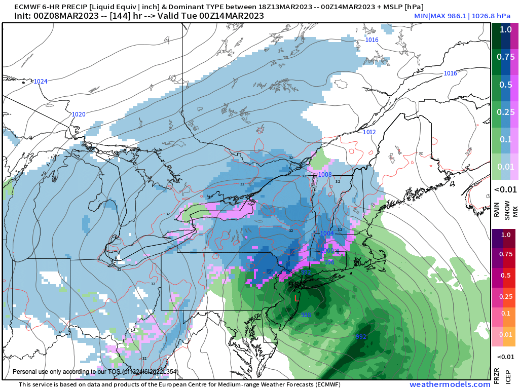
A storm looks to eject out of the southern U.S. with some Gulf moisture associated with it, and upper level features may also fall into place to produce a coastal low pressure system capable of delivering significant wintry impacts to at least parts of the greater WMass region, so stay tuned.
Have a great day and if you rely on my interactive community weather reporting, you can support it at any level as a Member of my Support Nutwork or as a Supporter – it’s your Choice.
2023 MEMBER/SUPPORT DRIVE SECURE LINK
Let’s Stay Together (click for options)
AND REMEMBER…
“Hello babies. Welcome to Earth. It’s hot in the summer and cold in the winter. It’s round and wet and crowded. On the outside, babies, you’ve got a hundred years here. There’s only one rule that I know of, babies: Goddamn it, you’ve got to be kind.”
–Kurt Vonnegut