
SECURELY BECOME A 2023 SUPPORT NUTWORKMEMBER OR SUPPORTER AT ANY LEVEL TODAY(Options include Cards, PayPal, Venmo, or Check)
~~~~~~~~~~~~~~~~~~~~~~
TABLE OF CONTENTS:
–Weekly Nutshell (Quick impact list)
–Sponsor Note (Tandem Bagel Co.)
–NWS Alerts (Advisories, Warnings, Watches)
–Celestial Data (Sun/Moon info)
–Regional Summaries (quick in and out details)
–Morning Discussion (Longer-form explanation)
~~~~~~~~~~~~~~~~~~~~~~
—> DHTWN REMINDER: It doesn’t take much to do a nice thing for somebody that you don’t know.
~~~~~~~~~~~~~~~~~~~~~~
DAVE’S WEEKLY WEATHER NUTSHELL
–Atlantic Canadian gyre generates cool northwest breezes with mixed clouds and sun for much of the week, mostly dry
–An isolated snow or rain shower may fall each day through Thursday, but would be rare across the region
–Cold and blustery today with highs in the upper 20s and 30s, then 30s and 40s rest of the week, breezy
–Friday becomes sunnier, milder
–Saturday may produce a light to moderate to coastal winter storm, but may be shunted out to sea by high pressure to the northwest
–Another coastal storm signal with lower pressure continues to show up for next Tuesday, but before we jump into the weather discussion/details below, let’s check a note from our local and delicious sponsor, #TandemBagelCo, with their newest location in West Springfield, MA.
~~~~~~~~~~~~~~~~~~~~~~
A NOTE FROM OUR SPONSOR:
Dave Hayes The Weather Nut is Sponsored by Individual Community Members, Patrons & Tandem Bagel Company… No matter the weather, Tandem Bagel is always there for you at several valley locations to make your mornings brighter! With bagels baked fresh daily (including Gluten-Free options), house-whipped cream cheese, coffee, and tons of lunch options, Tandem is the perfect quick stop for lunch, breakfast, or a coffee and bagel to go. Find them in Easthampton, Northampton, Hadley, Florence, and West Springfield, or use their super-streamlined online ordering tool by visiting their website.
~~~~~~~~~~~~~~~~~~~~~~~~~~~~~~~~
***DHTWN DAILY WEATHER REPORT***
~~~~~~~~~~~~~~~~~~~~~~~~~~~~~~~~
NATIONAL WEATHER SERVICE ALERTS
–None
DAILY CELESTIAL (STAR):
–OUR STAR ROSE AT: 6:16am this morning
–OUR STAR WILL SET AT: 5:47pm this evening
–TOTAL DAYLIGHT TIME: 11 hours and 31 minutes
NIGHTLY CELESTIAL (MOON):
–OUR MOON WILL RISE AT: 6:01pm this evening
–OUR MOON WILL SET AT: 6:57am tomorrow morning
–MOON RISE DIRECTION: East
–MOON SET DIRECTION: West
–MOON PHASE: Waning Gibbous (99.9%)
~~~~~~~~~~~~~~~~~~~~~~~~~~~~~~~~
DAILY TERRESTRIAL
ZONE 1 – Northern Region
(Southern VT, Southwest NH)
–High Temps: Upper 20s to Low 30s
–Low Temps: Upper Teens to Low 20s
–Winds: Northwest winds gust 20-30mph
–Sky Cover: Mostly Cloudy
–Precipitation: Isolated snow shower possible, otherwise dry
ZONE 2 – Central Region
(Western MA, North-Central MA, Northern Litchfield CT)
–High Temps: Upper 20s to Mid 30s
–Low Temps: Low to Mid 20s
–Winds: Northwest winds gust 25-35mph
–Sky Cover: Mostly Cloudy west, Partly Sunny east
–Precipitation: Isolated snow shower possible, otherwise dry
ZONE 3 – Southern Region
(South-Central MA, Northern CT)
–High Temps: Mid 30s to Low 40s
–Low Temps: Mid to Upper 20s
–Winds: Northwest winds gust 25-35mph
–Sky Cover: Partly Sunny
–Precipitation: None expected
~~~~~~~~~~~~~~~~~~~~~~~~~~~~~~~~
MORNING DISCUSSION
Good morning everybody, we’re sort of stuck in this northwest flow pattern with a large low pressure gyre circulating counterclockwise near Nova Scotia.
This feature is going to wobble around a bit, but is broadly stuck in that general region through Thursday or so.
This is going to send pinwheeling spokes of energy through our region, mostly in the form of periods of clouds mixed with partial sunshine over the next few days, but some of those clouds may drop an isolated snow or rain shower here and there.
Highs today will range from the upper 20s to upper 30s for most of us (30s in the valley, upper 20s in the northwest hills).
Northwest winds will gust 20-35 at times, and so it’ll be a blustery afternoon ahead, and chilly. Lows will drop into the upper teens to mid 20s for most of us.
Wednesday and Thursday look like copies of each other with highs in the mid 30s to low 40s and lows in the 20s under partly sunny skies with periods with mostly cloudy skies mixed in, gusty northwest breezes, and an isolated snow/rain shower possible.
By Friday, the influence of high pressure to our northwest will be pushing closer, weakening the pressure gradient, which will weaken the wind component, and also increase our sunshine, upping our temps into the upper 30s to mid 40s for highs.
———–
MAYBE YOU FEEL SIMILAR TO KELLI?
“Hi Dave, I just joined your membership. I just wanted to reach out and let you know how much your forecasting means to me. Believe me, if I had the means, I would contribute much more. I work as a behavior therapist with kiddos that have autism and I commute between Vermont and Massachusetts, over a 100 miles a day and your forecasts have been a huge blessing to me. They have allowed me to avoid unsafe predicaments, have allowed me to stay safe and make informed decisions. If you got paid by how many times I say, “well Dave says…” then you would be in good shape lol. I mention you so often that my family members thought that I actually knew you in real life. Of course when I explained who you really were, I directed them right to your page. Us in the valley and surrounding towns are so lucky to have our very own personal weather man. I appreciate you and your work so much. Thanks Dave.” –Kelli H.
–> Your Contributions Today Help Sustain this Community Weather Resource
–> Click this secure link to select from many support options, thanks!
——-
Clouds will increase at night and lows will drop into the 20s prior to the weekend.
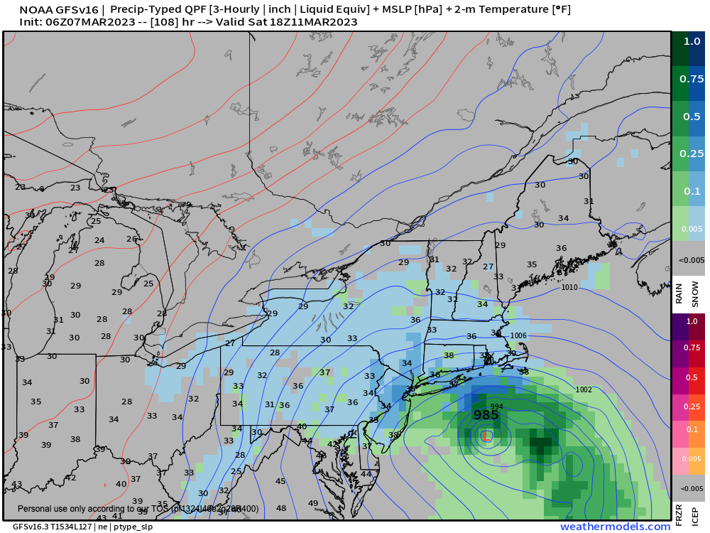
A storm will form *somewhere* off of the Mid-Atlantic or DelMarVa regions, but where it tracks on Saturday is still uncertain.
It’s possible we could be dealing with a mostly light snowstorm here, but it could easily be pushed out to sea by incoming high pressure, so I will have to update you as we get closer.
Sunday looks partly sunny and seasonable with highs either side of 40º, and while Monday starts off fair, we may see a larger coastal storm developing closer to New England for Monday night into Tuesday, and we can’t rule out an impactful snowstorm, so please stay tuned for updates on the Saturday and Tuesday potentials!
Have a great day and if you rely on my interactive community weather reporting, it’s 1 out of 25 of my readers that sustains this resource and I’m just 35% to my goal for my Member/Support Drive with less than 3 weeks to go… any monthly or one-time amount is helpful, thank you:
2023 MEMBER/SUPPORT DRIVE SECURE LINK.
Let’s Stay Together (click for options).
AND REMEMBER…
“Hello babies. Welcome to Earth. It’s hot in the summer and cold in the winter. It’s round and wet and crowded. On the outside, babies, you’ve got a hundred years here. There’s only one rule that I know of, babies: Goddamn it, you’ve got to be kind.”
–Kurt Vonnegut