RE: Relying on Each Other…
–The Goal: 4% reader contribution (we’re about 40% there, 60% to reach the goal)
–I care about your safety and of those you love
–I work to be as accurate, helpful, and interactive as I can
–Many of you have told me you rely on me because I show up
–Now I must rely on you for support to sustain my work
SECURELY BECOME A 2024 DHTWN SUPPORTER TODAY
(Options include Cards, PayPal, Venmo, Check)
~~~~~~~~~~~~~~~~~~~~~~
TABLE OF CONTENTS
* Daily Celestials (Sun/Moon Data)
* Weekly Weather Nutshell
* Morning Discussion
* TIP: Scroll below for sections, or read all
~~~~~~~~~~~~~~~~~~~~~~
YOUR DAILY CELESTIALS
~~~~~~~~~~~~~~~~~~~~~~
STAR:
–OUR STAR ROSE AT: 6:19am this morning
–OUR STAR SETS AT: 5:44pm this evening
–TOTAL DAYLIGHT TIME: 11 hours and 25 minutes
MOON:
–OUR MOON SETS AT: 10:47am this morning
–MOON SET DIRECTION: Southwest
–OUR MOON RISES AT: 3:22am this evening
–MOON RISE DIRECTION: Southeast
–MOON PHASE: Waning Crescent (41.2%)
~~~~~~~~~~~~~~~~~~~~~~
A NOTE FROM OUR SPONSOR
~~~~~~~~~~~~~~~~~~~~~~
Dave Hayes The Weather Nut is Sponsored by Individual Community Members, Patrons, and Tandem Bagel Company… No matter the weather, Tandem Bagel is always there for you at several valley locations to make your mornings brighter! With *New Pizza Bagels(!)*, along with bagels baked fresh daily (including Gluten-Free options), house-whipped cream cheese, coffee, and tons of lunch options, Tandem is the perfect quick stop for lunch, breakfast, or a coffee and bagel to go. Find them in Easthampton, Northampton, Hadley, Florence, and West Springfield, or use their super-streamlined online ordering tool by visiting their website.
~~~~~~~~~~~~~~~~~~~~~~
YOUR WEEKLY WEATHER NUTSHELL
~~~~~~~~~~~~~~~~~~~~~~
–Departing high pressure lingers enough to provide a dry day
–However, northeast flow off of the ocean supports low level moisture and cloudiness for a time
–Some sunny periods expected later as the atmospheric layers mix a bit better, highs in the 50s
–Clouds increase tonight as the high moves east and a weak low moves north up the eastern seaboard
–Lows drop to the upper 30s to low 40s
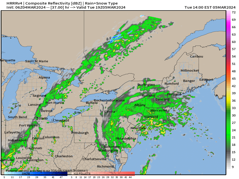
–A few showers are possible early Tuesday morning, but the steadier rain moves in by late morning and lasts through the afternoon
–Highs will only reach the mid 40s with patchy fog possible, with about a quarter to half inch of rain expected by midnight, by which time rain should have quit
–Wednesday looks milder with some morning sunny breaks possible before clouds increase again with highs in the 50s
–A more potent and juicy southern stream storm system tracks northeast out of the Appalachians and will push steady, heavier rainfall into our region by midnight as Wednesday becomes Thursday
———————————–
SECURELY BECOME A 2024 DHTWN SUPPORTER TODAY
Click–> https://westernmassweather.com/support-network/
~~~~~~~~~~~~~~~~~~~~~~
–This will combine with an incoming cold front to ring out as much as 1-2″ of rainfall over the region, which could produce some street flooding, with any minor flooding probably well east and southeast of the WMass region, but I will watch it.
–Rain lasts through most of Thursday with highs in the 40s and lows near freezing
–Friday is the pick of the week for sure, with high pressure building through with highs in the 45-50º range
–By Saturday, clouds are back and the potential for a Miller B, double-barrel low setup should be approaching
–Much detail remains uncertain in terms of the strength of the primary low, how it hands energy off to the secondary low near the coast, where that forms, how fast it deepens, how much colder air pulled south at the surface, and/or generated by the storm via dynamic cooling, etc., so please stay tuned
–This upcoming weekend system could have some wintry surprises for the high terrain of MA, VT and NH
~~~~~~~~~~~~~~~~~~~~~~
YOUR MORNING DISCUSSION
~~~~~~~~~~~~~~~~~~~~~~
Good morning everybody, the Nutshell above covers most of the details, but the bottom line is that we have entered this seesaw, alternating, oscillating, on/off, binary storm mode with plenty of clouds this week and above average temperatures overall.
Highs will be mostly in the 40s this week into the weekend, but today (and Wednesday especially) will be the mildest days with highs in the 50s.
We’ll be dry today, wet tomorrow, dry Wednesday, wet Thursday, dry Friday (the pick of the week with actual sunshine!) and wet again by next week, with further potential for a dry Sunday and a wet next Monday!
Cripes, as my Nana would say!
Truly seesaw weather, but mostly in terms of precipitation and moisture, and not temps which will be steadier above average generally speaking.
Next Saturday’s storm does look interesting, but these late-season setups where you “need” ingredients to come together just so (most importantly the cold air) to produce wintry events is not something for winter weather enjoyers to hang their hats on.
Still, there will be colder air to our north, and depending where and how fast/strong a secondary low gets going, some folks in our region could be dealing with some wintry precipitation, so please stay tuned for updates.
I hope you have a great day, and as we head towards Spring and severe summer weather potentials and impacts, it’s the folks that rely on and value my work that keep these reports going, so I’d welcome your support during my annual 2024 support drive to keep active this year (options include Cards, PayPal, Venmo, or Check, thank you!)
———————————–
SECURELY BECOME A 2024 DHTWN SUPPORTER TODAY
(Options include Cards, PayPal, Venmo, Check)
~~~~~~~~~~~~~~~~~~~~~~
>>> BE KIND <<<
“Hello babies. Welcome to Earth. It’s hot in the summer and cold in the winter. It’s round and wet and crowded. On the outside, babies, you’ve got a hundred years here. There’s only one rule that I know of, babies: Goddamn it, you’ve got to be kind.”
–Kurt Vonnegut
