
WE’RE ABOUT 40% TO THE
4% READER DONATION GOAL
–I’m here most every day & for every storm
–I’m focused on your safety and of those you love
–I work to be as detailed, accurate, helpful, & interactive as I can
–Many of you have told me you rely on me
–If you do, I need to rely on your modest support to sustain my work
SECURELY BECOME A 2024 DHTWN SUPPORTER TODAY
(Options include Cards, PayPal, Venmo, Check)
Click–> https://westernmassweather.com/support-network/
~~~~~~~~~~~~~~~~~~~~~~
TABLE OF CONTENTS
* Daily Celestials (Sun/Moon Data)
* Weekly Weather Nutshell
* Morning Discussion
* TIP: Scroll below for sections, or read all
~~~~~~~~~~~~~~~~~~~~~~
YOUR DAILY CELESTIALS
~~~~~~~~~~~~~~~~~~~~~~
STAR:
–OUR STAR WILL RISE AT: 6:21am this morning
–OUR STAR WILL SET AT: 5:43pm this evening
–TOTAL DAYLIGHT TIME: 11 hours and 22 minutes
MOON:
–OUR MOON WILL SET AT: 9:58am this morning
–MOON SET DIRECTION: Southwest
–OUR MOON WILL RISE AT: 2:20am tomorrow morning
–MOON RISE DIRECTION: Southeast
–MOON PHASE: Waning Crescent (51.2%)
~~~~~~~~~~~~~~~~~~~~~~
>>> A NOTE FROM OUR SPONSOR <<<
Dave Hayes The Weather Nut is Sponsored by Individual Community Members, Patrons, and Gerard, Ghazey & Bates, P.C. GGBPC is a Northampton-based law firm regarded as the voice of pragmatic and well-reasoned estate planning, elder law and tax guidance in Western Massachusetts. The firm specializes in estate planning law, and expertly handles other matters such as Elder Law, Tax Law, as well as Real Estate purchase, sales, and refinance transactions. Contact GGBPC today to see how they can help! Click: https://www.ggbpc.com/
~~~~~~~~~~~~~~~~~~~~~~
YOUR WEEKLY WEATHER NUTSHELL
~~~~~~~~~~~~~~~~~~~~~~
–Patchy fog, some dense in southwest VT, burns off later this morning… a bit of mist in CMass is noted as well
–Generally we should be drying today, but low level moisture in the form of clouds will persist, mixed with sunny breaks
–Towards the afternoon, the lower lying parts of WMass (like the Pioneer Valley) should break into more sun, with highs in the mid to upper 50s
–Lows tonight drop to the upper 30s to low 40s under mostly cloudy skies
–Monday should feature more clouds than today with highs in the mid 50s, and patchy fog possible in the morning
–Monday night lows will drop to near 40º
–By Tuesday, a weak storm system will be guided north up the coast and into southern New England
–This will bring more rainfall by afternoon and evening
–Highs will only reach the mid 40s or so with lows near 40º with more showers
———
–If you depend on my work, please click to keep this resource cranking out interactive hype-free weather reports, thx!
https://westernmassweather.com/support-network/
———
–Wednesday should be the mild spike of the week with highs well into the 50s to near 60º as we move between systems
–A stronger southern stream storm will bring more rain, heavy at times, by Thursday which may end as a period of snow or ice in the usual high terrain parts of the greater WMass region in northern MA, SVT and SWNH as a cold front comes through
–Friday looks like another lull with highs in the mid 40s under partly sunny skies
–However, by Saturday a more interesting storm setup is plausible that bring a wet snowfall to parts of our region with a Miller B setup that has a primary low dying into western NY and the eastern Great Lakes, with a secondary low forming off of the Mid-Atlantic and staying south of us
–Admittedly, a lot would have to come together to produce a wet snowstorm for our region, and while less likely, it can’t be ruled out so please stay tuned for updates as it is many days away
~~~~~~~~~~~~~~~~~~~~~~
YOUR MORNING DISCUSSION
~~~~~~~~~~~~~~~~~~~~~~
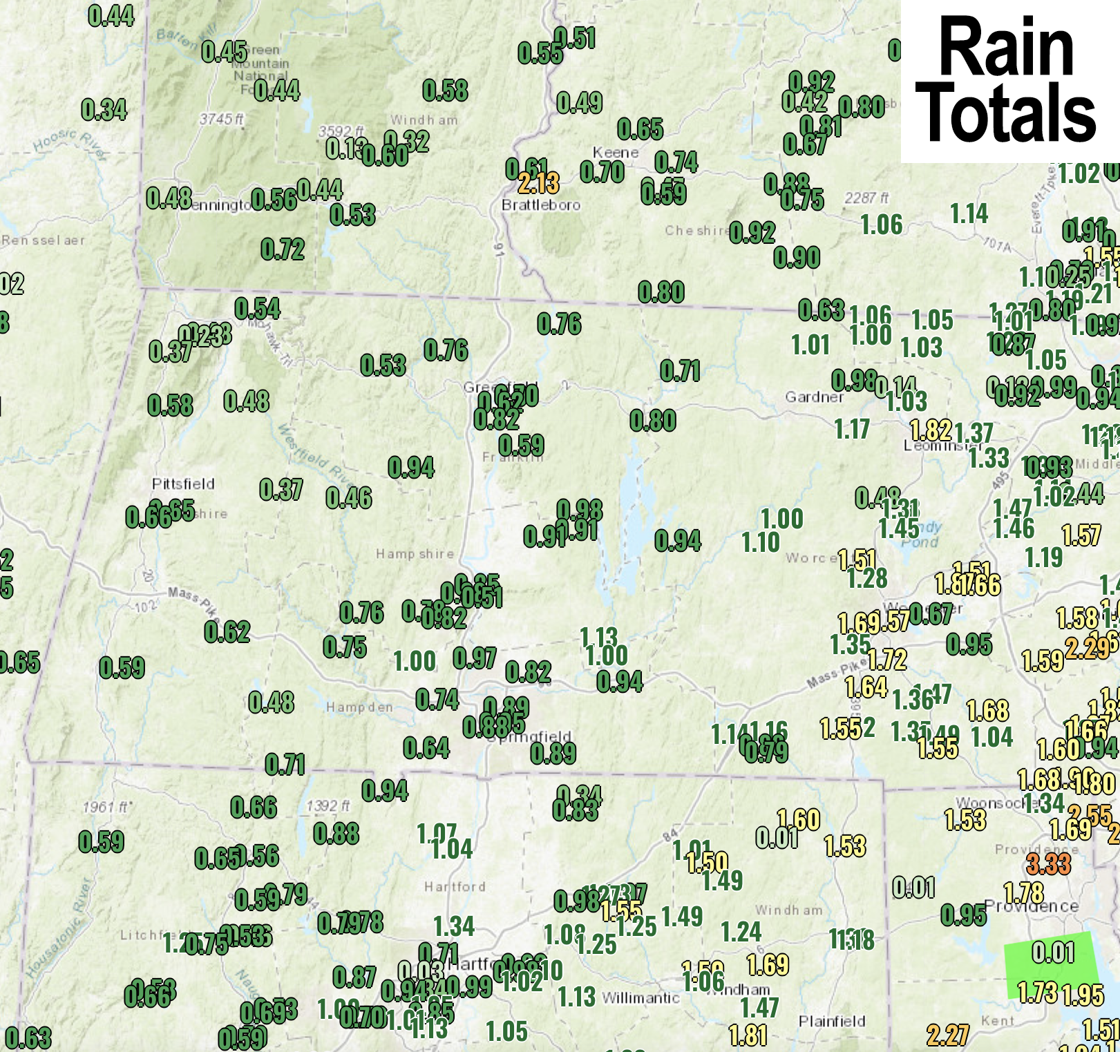
Good morning everybody, most of us saw between a half an inch to an inch of rain yesterday and overnight, with over an inch in parts of northern CT and CMass, and under half an inch in other parts of SVT and WMass.
What lingers is low level moisture in the form of clouds, as well as some patchy fog and mist patches, but we should be drying the surface out, but not the cloud deck entirely with partly sunny skies on average, and some high terrain areas seeing more clouds than sun.
The Nutshell section above handles most of the salient weather points, so all I really want to convey this morning is that we have an active storm period coming up, and by end of the week into next weekend, cold air will not be that far away to the north.
All this to say, that after Tuesday’s rain showery system, and Thor’s Daytime rainfall, once we get to Thursday night and then again next weekend, we need to stay alert to wintry precip potential.
It’s March, and it’s also this lame winter, so odds are it doesn’t come to pass, but elements could align to produce impactful wintry weather conditions, so stay tuned and I will keep you updated as we get closer to these events.
Have an awesome day and if you depend on my work each year, please chip in whatever is comfortable for you at the secure link below so I can continue through 2024… even $5 helps, thank you…
SECURELY BECOME A 2024
DHTWN SUPPORTER TODAY
(Options include Cards, PayPal, Venmo, Check)
Click–> https://westernmassweather.com/support-network/
>>> BE KIND <<<
“Hello babies. Welcome to Earth. It’s hot in the summer and cold in the winter. It’s round and wet and crowded. On the outside, babies, you’ve got a hundred years here. There’s only one rule that I know of, babies: Goddamn it, you’ve got to be kind.”
–Kurt Vonnegut