
SECURELY BECOME A 2023 MEMBER OR SUPPORTER AT ANY LEVEL TODAY(Options include Cards, PayPal, Venmo, or Check)
~~~~~~~~~~~~~~~~~~~~~~
TABLE OF CONTENTS:
–Weekly Nutshell (Quick impact list)
–Sponsor Note (Tandem Bagel Co.)
–NWS Alerts (Advisories, Warnings, Watches)
–Celestial Data (Sun/Moon info)
–Regional Summaries (quick in and out details)
–Morning Discussion (Longer-form explanation)
~~~~~~~~~~~~~~~~~~~~~~
—> DHTWN REMINDER: It doesn’t take much to do a nice thing for somebody that you don’t know.
~~~~~~~~~~~~~~~~~~~~~~
DAVE’S WEEKLY WEATHER NUTSHELL
–Partly to mostly sunny start, clouds increase as the day wears on, high/mid clouds first, low clouds late afternoon
–Snow arrives 7-10pm, may fall heavily before midnight
–Snow/sleet line pushes north into northern CT by midnight, and northward through WMass/CMass during the pre-dawn hours
–Bit of a milder look this morning, so ranges of 2-5″ south of Rt. 2 and 5-10″ north of Rt. 2 offered for past couple of days remain, but could see lower end of those ranges #Winter2022and2023
–Easterly winds gust 25-40mph after midnight into Saturday
–Freezing rain now possible in northern CT for a time early Saturday morning
–Everybody goes back to snow by later Saturday morning, but storm will be winding down
–Fair weather Sunday and Monday
–Light snow possible Tuesday, and another larger storm by next Friday/Saturday could bring more winter weather, but before we jump into the weather discussion/details below, let’s check a note from our local and delicious sponsor, #TandemBagelCo, with their newest location in West Springfield, MA.
~~~~~~~~~~~~~~~~~~~~~~
A NOTE FROM OUR SPONSOR:
Dave Hayes The Weather Nut is Sponsored by Individual Community Members, Patrons & Tandem Bagel Company… No matter the weather, Tandem Bagel is always there for you at several valley locations to make your mornings brighter! With bagels baked fresh daily (including Gluten-Free options), house-whipped cream cheese, coffee, and tons of lunch options, Tandem is the perfect quick stop for lunch, breakfast, or a coffee and bagel to go. Find them in Easthampton, Northampton, Hadley, Florence, and West Springfield, or use their super-streamlined online ordering tool by visiting their website.
~~~~~~~~~~~~~~~~~~~~~~~~~~~~~~~~
***DHTWN DAILY WEATHER REPORT***
~~~~~~~~~~~~~~~~~~~~~~~~~~~~~~~~
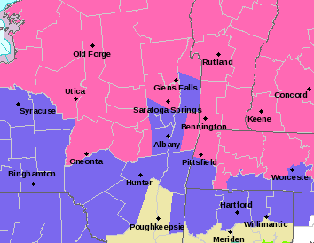
NATIONAL WEATHER SERVICE ALERTS
–Winter Weather Advisories are up for the southern Berkshires, central/eastern Hampden County, and southern Worcester County in MA, and all of northern CT
–Winter Storm Warnings are up the northern Berkshires, the western hilltowns, Hampshire, Franklin and northern Worcester Counties in MA, and all of SVT and SWNH
DAILY CELESTIAL (STAR):
–OUR STAR ROSE AT: 6:22am this morning
–OUR STAR WILL SET AT: 5:42pm this evening
–TOTAL DAYLIGHT TIME: 11 hours and 20 minutes
NIGHTLY CELESTIAL (MOON):
–OUR MOON WILL RISE AT: 1:48pm this afternoon
–OUR MOON WILL SET AT: 5:24am tomorrow morning
–MOON RISE DIRECTION: Northeast
–MOON SET DIRECTION: Wet-Northwest
–MOON PHASE: Waxing Gibbous (85.7%)
~~~~~~~~~~~~~~~~~~~~~~~~~~~~~~~~
DAILY TERRESTRIAL
ZONE 1 – Northern Region
(Southern VT, Southwest NH)
–High Temps: Mid to Upper 30s
–Low Temps: Mid 20s to Low 30s
–Winds: Light north wind veers to easterly gusting 25-40mph overnight
–Sky Cover: Mostly sunny early, becoming overcast by late day
–Precipitation: Dry today, then snow arrives 7-10pm, mixes with sleet toward dawn Saturday
ZONE 2 – Central Region
(Western MA, North-Central MA, Northern Litchfield CT)
–High Temps: Upper 30s to Low 40s
–Low Temps: Upper 20s to Low 30s
–Winds: Light north wind veers to easterly gusting 25-40mph overnight
–Sky Cover: Mostly sunny early, becoming overcast by late day
–Precipitation: Dry today, then snow arrives 7-10pm, mixes with or turns to sleet after midnight
ZONE 3 – Southern Region
(South-Central MA, Northern CT)
–High Temps: Low 40s
–Low Temps: Low 30s
–Winds: Light north wind veers to easterly gusting 25-40mph overnight
–Sky Cover: Mostly sunny early, becoming overcast by late day
–Precipitation: Dry today, then snow arrives 7-10pm, changes to sleet around midnight or just after, sleet and freezing rain possible by dawn early Saturday morning
~~~~~~~~~~~~~~~~~~~~~~~~~~~~~~~~
MORNING DISCUSSION
Good morning everybody, thanks so much for watching the piece on ConnectingPoint last night, I appreciate all of the positive feedback, I’m very grateful to the folks at NEPM for putting it together, and if you missed it and want to see it you can watch it here.
As for our weather, I am going to rip into some double–dashes and get the lead out, let’s get down to business, kids!
–We’ve got fair weather this morning, and we’ll be dry through the daylight hours
–Highs will reach the mid 30s to low 40s for most of us, with clouds building through the day
–Our primary low tracks into Lake Erie later tonight and spawns a secondary low off of the NJ coast overnight which hugs the southern New England coast tomorrow
–This will push snow into the region starting between 7-10pm this evening
–Milder air will rush northward into our latitudes about 2 miles aloft, causing mixes with and changes to sleet from north to south after midnight
–Freezing rain may work into parts of northern CT by dawn
–Best chance for all snow is in SVT and SWNH, as I think even in far northern MA mixes with sleet for a time, and it may sleet north of the MA line as well
–Heaviest precip falls overnight and tapers off before noon, I believe
–Any mix should change back to snow by later morning before tapering to flurries
–Northern CT may dry slot Saturday morning, with little to no precip, depending where the dry slot sets up
–This storm has marginal temperatures up and down the column (surface to sky), so any slight changes in temp will cause the reality on the ground to change from the above thinking
–I still am going with 2-5″ south of Rt. 2 in MA and northern CT (though wouldn’t be surprised to see 1-3″ in much of north-central and northeast CT)
–I am still going with 5-10″ along and north of Rt. 2 corridor, but lower ends of both of these ranges is more likely than not what will transpire if mild trend continues
–Some areas in the southern Greens could see over a foot
~~~~~~~~~~~~~~~~~~~~~~
SECURELY BECOME A 2023 MEMBER OR SUPPORTER AT ANY LEVEL TODAY(Options include Cards, PayPal, Venmo, or Check)
~~~~~~~~~~~~~~~~~~~~~~
–Easterly winds (after light north wind today) will pick up tonight and tomorrow, gusting 25-40mph at times
–Highs will be in the mid to upper 30s Saturday, and a few snow showers may linger into the evening, with lows in the 20s
–Sunday looks partly sunny with highs near 40º, and Monday looks mostly sunny with high pressure settling through with highs in the low 40s, so a pair of nice days are coming after this storm!
–Another Clipper low may swing through Tuesday with a period of light snow, then more fair weather with seasonable temps through the week until Friday
–A major storm may bring more snow and rain to the region, so stay tuned for updates on that
Have a great day, I will update again by late afternoon as the storm is moving in, and if you appreciate and value my work, please consider supporting it via my 2023 Member/Support Drive… any monthly or one-time amount is helpful, thank you:
2023 MEMBER/SUPPORT DRIVE SECURE LINK
Let’s Stay Together (click for options)
AND REMEMBER…
“Hello babies. Welcome to Earth. It’s hot in the summer and cold in the winter. It’s round and wet and crowded. On the outside, babies, you’ve got a hundred years here. There’s only one rule that I know of, babies: Goddamn it, you’ve got to be kind.”
–Kurt Vonnegut