TABLE OF CONTENTS
* Daily Celestials (Sun/Moon Data)
* Weekly Weather Nutshell
* Morning Discussion
* TIP: Scroll below for sections, or read all
~~~~~~~~~~~~~~~~~~~~~~
YOUR DAILY CELESTIALS
~~~~~~~~~~~~~~~~~~~~~~
STAR:
–OUR STAR ROSE AT: 6:37am this morning
–OUR STAR SETS AT: 7:13pm this evening
–TOTAL DAYLIGHT TIME: 12 hours and 36 minutes
MOON:
–OUR MOON SETS AT: 8:23am this morning
–MOON SET DIRECTION: West-Southwest
–OUR MOON RISES AT: 12:04am tomorrow morning
–MOON RISE DIRECTION: Southeast
–MOON PHASE: Waning Gibbous (84.6%)
~~~~~~~~~~~~~~~~~~~~~~
A NOTE FROM OUR SPONSOR
~~~~~~~~~~~~~~~~~~~~~~
Dave Hayes The Weather Nut is Sponsored by Individual Community Members, Patrons, and Tandem Bagel Company… No matter the weather, Tandem Bagel is always there for you at several valley locations to make your mornings brighter! With *New Pizza Bagels(!)*, along with bagels baked fresh daily (including Gluten-Free options), house-whipped cream cheese, coffee, and tons of lunch options, Tandem is the perfect quick stop for lunch, breakfast, or a coffee and bagel to go. Find them in Easthampton, Northampton, Hadley, Florence, and West Springfield, or use their super-streamlined online ordering tool by visiting their website.
~~~~~~~~~~~~~~~~~~~~~~
YOUR WEEKLY WEATHER NUTSHELL
~~~~~~~~~~~~~~~~~~~~~~
–Rain and any mixed snow ends this morning
–Mostly cloudy skies give way to partly sunny skies later with highs in the mid 40s to low 50s
–Northwest flow behind the storm dries us out
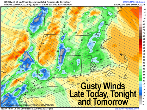
–Gusts will kick up to 25-40mph by this afternoon given increasing pressure gradient with high pressure to our SW
–Gusts may reach 45mph overnight at elevation, lows drop to the upper 20s to low 30s
–Saturday features blustery conditions for the morning into afternoon before slackening
–Mostly sunny skies should prevail most of the day with highs in the low to mid 50s
–Lows will drop into the mid 30s as a weak system brings a few mixed showers through our region
–Highs Sunday will settle either side of 50º under partly sunny skies with lows near freezing
–Monday crests the low 50s with fair weather, but clouds develop at night as we head into an unsettled period
–Tuesday through Thursday looks unsettled with potential for substantial precipitation, including rain and accumulating snow
–By mid week, a potent coastal low may be parked right off of Cape Cod
–Late-season winter storms have happened before, and will happen again, so stay tuned for updates on this storm signal
~~~~~~~~~~~~~~~~~~~~~~
YOUR MORNING DISCUSSION
~~~~~~~~~~~~~~~~~~~~~~
Good morning everybody, our storm system that brought all of our rain yesterday and overnight (mostly half an inch to 1.5″), including some snow that mixed in on the back end is departing to the north and northeast this morning, with remnant showers located mainly in the eastern half of Worcester County and northeast CT, into EMass.
As high pressure starts squeezing the pressure gradient from the southwest, northwest winds are going to start advecting drier air into our region, thinning our mostly cloudy skies and bringing in some partly sunny skies by sometime this afternoon.
Highs reach the mid 40s to low 50s and northwest winds will gust 25-40mph by this afternoon and evening, and kick up too 30-45mph overnight, especially in the high terrain with lighter valley gusts, and lows in the upper 20s to low 30s.
For Saturday, a blustery start under mostly sunny skies will feature gusty winds into early afternoon before they slacken late, with highs in the low to mid 50s.
A weak wave whiffs through the region at night with a few showers of rain or snow mix and lows in the mid 30s, with partly sunny skies developing into Sunday behind that weak whiffer, with highs rising into the upper 40s to low 50s, with lows near the freezing mark.
Monday marks one last fair weather day with highs in the 50s, but a cold front will be approaching, along with an upper trough and the confluence of northern and southern stream energy that has the potential to lead to explosive coastal low development such that accumulating snow could develop in our high terrain areas, along with a snow and rain mix in the valley, falling heavily at times especially Wednesday into Thursday.
There is growing support for this strong storm signal, so please stay tuned for updates, as we can never rule out accumulating snow until mid May year to year.
Have a great day!
>>> BE KIND <<<
“Hello babies. Welcome to Earth. It’s hot in the summer and cold in the winter. It’s round and wet and crowded. On the outside, babies, you’ve got a hundred years here. There’s only one rule that I know of, babies: Goddamn it, you’ve got to be kind.”
–Kurt Vonnegut
