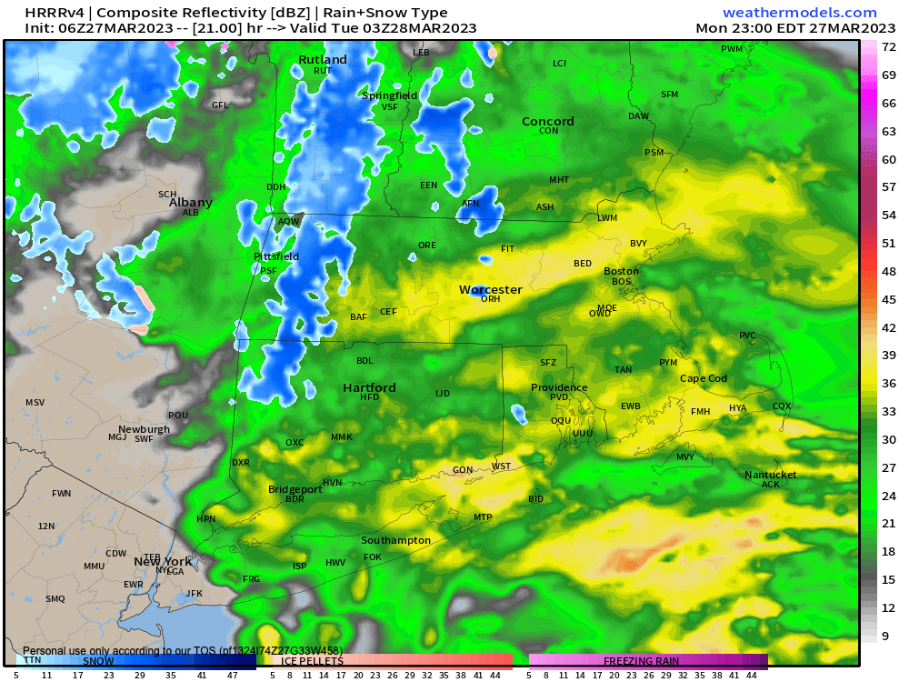
Rain and high terrain snow later tonight
I’m going to pound my dash key mercilessly below, to summarize our salient weather details, but first let’s a check a note from our Sponsor, Tandem Bagel Company:
~~~~~~~~~~~~~~~~~~~~~~
A NOTE FROM OUR SPONSOR:
Dave Hayes The Weather Nut is Sponsored by Individual Community Members, Patrons & Tandem Bagel Company… No matter the weather, Tandem Bagel is always there for you at several valley locations to make your mornings brighter! With bagels baked fresh daily (including Gluten-Free options), house-whipped cream cheese, coffee, and tons of lunch options, Tandem is the perfect quick stop for lunch, breakfast, or a coffee and bagel to go. Find them in Easthampton, Northampton, Hadley, Florence, and West Springfield, or use their super-streamlined online ordering tool by visiting their website.
~~~~~~~~~~~~~~~~~~~~~~
SUMMARY
–We’re going to enjoy a mostly sunny first half of the day with highs in the upper 40s to mid 50s with light southwest wind, so enjoy and get out for a morning or lunch time walk!
–Clouds will build, and we’ve got a potent but exceedingly small little wave that will track south of the region tonight
–It will bring a burst of rain and snow mainly after sunset, starting as rain everywhere
–With time, the dry air in place with help cool temps at the higher elevations, with lows everywhere down into the low to mid 30s
–This will be enough to flip the mountains of southern VT to snow first, before midnight
–Then a mix with and change to snow should occur in parts of the Berkshires and western hilltowns more toward midnight, and then around or after midnight in the high terrain east of the I-91 corridor including CMass
–By morning some folks could see a coating to an inch or so on the ground but roads should be mostly wet with a few slick spots
–While rain should continue in the Pioneer Valley, it may mix with snow after midnight
–There is a low chance we all flip to snow in the later pre-dawn hours which may cause some visibility issues during the early commute
–This system sails out of here early Tuesday morning, but some instability showers of rain or show may remain toward the mid-day timeframe
–Highs Tuesday will be cooler in the low to mid 40s and it should be a mostly cloudy day
–Lows will dip into the mid to upper 20s Tues. night
–Wednesday looks like the pick of the week with mostly sunny skies and highs in the mid 40s to low 50s
–However, a sharp cold front will be blasting through Wednesday night, and there are some indications that snow squalls may pass through overnight and coat the ground in places
–Lows will drop firmly in the 20s, and then we can expect a cold and blustery Thursday with winds gusting up to 40mph with highs only in the mid 30s to low 40s under partly sunny skies with lows in the 20s
–Friday and Saturday will see a large low pressure system tracking northwest of us out of the Southwest U.S. that will sweep milder air into the 50s to low 60s with rain showers arriving Friday afternoon
–Friday night through Saturday is looking pretty rainy at this point in time, and breezy as well, but mild
–Sunday looks like the weekend pick for sure with highs in the 40s under sunny skies and breezy
Have a great day!
BE KIND
“Hello babies. Welcome to Earth. It’s hot in the summer and cold in the winter. It’s round and wet and crowded. On the outside, babies, you’ve got a hundred years here. There’s only one rule that I know of, babies: Goddamn it, you’ve got to be kind.”
–Kurt Vonnegut
