
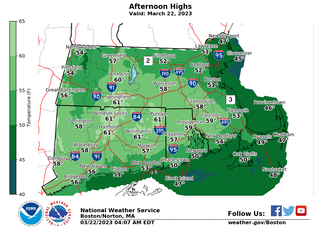
Wednesday high temps
–> Supported services remain
–> Unsupported resources wither
–> Your Contributions Today Help Sustain this Community Weather Resource for Tomorrow
–> 2023 Support Goal = 4% of readers (1 in 25) donating
–> 2023 Goal Progress = 57% have contributed
–> 2023 Support Drive end date = **SUNDAY**
–> Currently need 911 patron-donors out of 51,791 readers to reach the goal
–> Will you be one of the 1 in 25 to contribute $10, $35, or more if you are able? Or $3/month?
–> SecureSupportClickBelow for Options
——————-
TABLE OF CONTENTS:
–DHTWN Reminder (Be Nice)
–Weekly Nutshell (Quick impact list)
–Sponsor Note (Tandem Bagel Co.)
–NWS Alerts (Advisories, Warnings, Watches)
–Celestial Data (Sun/Moon info)
–Regional Summaries (Quick in/out details)
–Morning Discussion (More Details)
~~~~~~~~~~~~~~~~~~~~~~
DHTWN REMINDER: It doesn’t take much to do a nice thing for somebody that you don’t know.
~~~~~~~~~~~~~~~~~~~~~~
DAVE’S WEEKLY WEATHER NUTSHELL
–Partly sunny day with highs in the 50s to low 60s, nice!
–Clouds increase tonight as a warm front moves through, bringing some showers by early morning
–Another mild day tomorrow, but cloudy with scattered morning showers, a lull, and then more robust showers by later afternoon and evening as a cold front moves through
–Southwest wind gusts may kick up to 25mph late Thursday
–Friday is a bit cooler and mostly cloudy with highs mostly in the 40s to low 50s possible, a bit blustery out of the northwest with gusts to 30mph
–Colder Friday night low in the upper 20s
–Clouds continue Saturday with snow and rain showers moving into the region by late morning
–A storm passes north of us, but a secondary low develops south and holds some cold into the region, creating a wintry mix into Saturday evening
–Drier Sunday but some snow showers possible, and then another chance for rain and snow Monday night into Tuesday, but before we jump into the weather discussion/details below, let’s check a note from our local and delicious sponsor, #TandemBagelCo, with their newest location in West Springfield, MA.
~~~~~~~~~~~~~~~~~~~~~~
A NOTE FROM OUR SPONSOR:
Dave Hayes The Weather Nut is Sponsored by Individual Community Members, Patrons & Tandem Bagel Company… No matter the weather, Tandem Bagel is always there for you at several valley locations to make your mornings brighter! With bagels baked fresh daily (including Gluten-Free options), house-whipped cream cheese, coffee, and tons of lunch options, Tandem is the perfect quick stop for lunch, breakfast, or a coffee and bagel to go. Find them in Easthampton, Northampton, Hadley, Florence, and West Springfield, or use their super-streamlined online ordering tool by visiting their website.
~~~~~~~~~~~~~~~~~~~~~~~~~~~~~~~~
***DHTWN DAILY WEATHER REPORT***
~~~~~~~~~~~~~~~~~~~~~~~~~~~~~~~~
NATIONAL WEATHER SERVICE ALERTS
–None.
DAILY CELESTIAL (STAR):
–OUR STAR ROSE AT: 6:50am this morning
–OUR STAR WILL SET AT: 7:04pm this evening
–TOTAL DAYLIGHT TIME: 12 hours and 14 minutes
NIGHTLY CELESTIAL (MOON):
–OUR MOON WILL SET AT: 8:25pm this evening
–OUR MOON WILL RISE AT: 7:51am tomorrow morning
–MOON SET DIRECTION: West
–MOON RISE DIRECTION: East-Northeast
–MOON PHASE: Waxing Crescent (0.8%)
~~~~~~~~~~~~~~~~~~~~~~~~~~~~~~~~
DAILY TERRESTRIAL
ZONE 1 – Northern Region
(Southern VT, Southwest NH)
–High Temps: Low to Mid 50s
–Low Temps: Upper 30s to Low 40s
–Winds: Light southeast wind
–Sky Cover: Partly Sunny
–Precipitation: Dry
ZONE 2 – Central Region
(Western MA, North-Central MA, Northern Litchfield CT)
–High Temps: Mid 50s to Low 60s
–Low Temps: Low to Mid 40s
–Winds: Light southeast wind
–Sky Cover: Partly Sunny
–Precipitation: Dry
ZONE 3 – Southern Region
(South-Central MA, Northern CT)
–High Temps: Upper 50s to Low 60s
–Low Temps: Low to Mid 40s
–Winds: Light southeast wind
–Sky Cover: Partly Sunny
–Precipitation: Dry
~~~~~~~~~~~~~~~~~~~~~~~~~~~~~~~~
LET’S STAY CONNECTED
Visit this page on my website on Staying Connected
~~~~~~~~~~~~~~~~~~~~~~~~~~~~~~~~
MORNING DISCUSSION
Good morning everybody, we’ll see some cloudiness at times today, especially early this morning, but we should end up with a partly sunny day on average.
It will be quite mild with highs mostly in the mid 50s to low 60s, so get out and enjoy it!
Today, however, will be our last dry day for the next several (though Friday should be mostly dry, save for an early morning shower).
Clouds will build tonight in advance of a warm front that will push through and keep our lows either side of 40º.
We should see some scattered early morning showers, but those should wane as we approach late morning to mid-day Thursday, with continuing cloudy skies and highs in the 50s.
As a cold front approaches from the west tomorrow, a more robust round of showery weather will push into the region during the later afternoon and evening, so grab the umbrellas if you are heading out for any reason. Lows will drop to near freezing.
Friday looks cooler behind the front, and despite an early morning shower, it should be mostly dry with highs in the 40s to low 50s under mostly cloudy skies. Lows will bottom out in the upper 20s.
Saturday and Saturday night holds some wintry weather potential with a mix of snow, sleet and rain arriving Saturday later morning.
Highs will only rise into the 35-40º range, so while the valley will likely be mostly or all rain, the high terrain above 1000 feet could see a mix of snow, sleet and rain at times during the day, which may change to all snow and sleet as a secondary low develops and passes south of us into the evening, pulling colder air into those high terrain areas.
We can’t rule out minor snow/sleet accumulations, but shouldn’t be much more than a coating to 2-3″ the way it looks now.
For Sunday, highs will rise into the 40s with a few mixed showers possible early.
Monday looks quite nice with high pressure building through for a day and highs in the 40s, but we cloud up again late, and another storm may take advantage of a night time onset and bring more snow and rain to the region, but it, too, does not look like a major storm system.
I will keep you updated! Have a great day, and please become one of the remaining 911 patrons out of almost 52,000 to help support my work before my drive ends this weekend, I hope to keep serving the entire community, thank you.
————————————–
WHAT WILL I GET WHEN I JOIN DHTWN’s
2023 SUPPORT NUTWORK TODAY?
–> COMMITMENT – You get a humble human who intends on delivering hyper-local, timely and educational weather reports with humility, humor, gratitude, and big-picture perspective to help you plan your days optimally.
–> SecureCLICK
BE KIND
“Hello babies. Welcome to Earth. It’s hot in the summer and cold in the winter. It’s round and wet and crowded. On the outside, babies, you’ve got a hundred years here. There’s only one rule that I know of, babies: Goddamn it, you’ve got to be kind.”
–Kurt Vonnegut