
~~~~~~~~~~~~~~~~~~~~~~
SECURELY BECOME A 2023 MEMBER OR SUPPORTER AT ANY LEVEL TODAY(Options include Cards, PayPal, Venmo, or Check)
~~~~~~~~~~~~~~~~~~~~~~
Good evening everybody, we got a bit of partial sunshine in some areas today and temps finally did come up into the 40s for the most part based on max temp observations.
We have a few snow showers in SVT that represent the dying wraparound moisture of a snowfall ending in Maine tonight, which was that low that tracked north of us and brought rain and freezing rain earlier today.
For tonight, we should see additional clearing as drier air works into the region with northwest winds gusting 10-20mph with lows in the low to mid 20s – it’ll be chilly by morning, I do declare! Or is that spelled #declayah
Speaking of tonight, if you can, please check out ConnectingPoint on public TV WGBY out of Springfield (or stream it) in just 30 minutes, at 7:30pm, as they will be airing a piece on my work over the past decade (link below):
ConnectingPoint LiveStream of DHTWN
STORM SETUP AND ISSUES RE: SNOW VS. SLEET
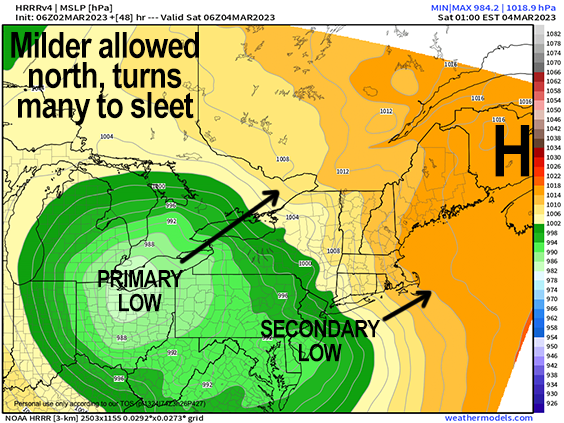
Moving on, Friday will start off with some partial morning sunshine, but high clouds will be building into the region as our primary storm that is bringing severe weather to Texas, Oklahoma and Arkansas tonight keeps trucking northeast into the Ohio Valley.
One note of noteworthiness is that some guidance is showing the upper level component to this storm taking on a more positive tilt down near the South, but why does that matter?
Usually, we want to see a negative tilt with Ohio Valley upper troughs to help guide storms up the coast and strengthen them, while keeping us on the cold side of the storm for more snow.
In this case, snow lovers (who do not want to be disappointed) *want* to see this trend toward a positive tilt continue, because it would carry the storm a bit more east than originally expected, resulting in the primary low tracking over or just south of Lake Erie (not westward into northern Ohio), which would allow the secondary low pressure system to form off of the NJ coast a bit more southerly and help hold colder air in another 10 to 20 miles south as it tracks toward Nantucket vs. Narragansett Bay, RI.
The second note of noteworthiness is that this would help keep a fairly roaring mid-level jet streak about 2 miles aloft from ripping too far north through MA and into VT and NH.
It is the height of this jet streak (about 2 miles aloft, which is higher up than usual) which will help ensure that the cold layer adjacent to the surface will be THICKER, meaning way more time for melted snowflakes to refreeze into ice pellets, a/k/a sleet.
Given that, it looks like we’re either seeing snow and/or sleet form this storm, with any freezing rain or rain likely staying south of even northern CT.
FRONT END THUMP AND TIMING
As our primary low transfers its energy to the coastal secondary low, a wide band of heavier precipitation in the form of snow is going to track northeast into the greater WMass region after a dry Friday with highs in the upper 30s, arriving between 6-9pm, which is a touch faster than the original 7-10pm thinking. The bottom line is that it mostly misses the evening commute, so that’s good news.
It will be dry due to high pressure brushing through the region tonight and tomorrow, so any marginal temps are likely to cool down as precipitation falls into that drier surface (a/k/a evaporative cooling), and this should allow for snow to, once it starts falling, to pick up in intensity pretty quickly.
It should be snowing everywhere through midnight and into the early pre-dawn hours with up to an inch per hour snowfall rate.
Again, like Monday’s night snowstorm, the bulk of precip falls Friday night late into early Saturday.
After this snow thump, we have to watch our far north that warm nose gets aloft, which will turn some of us over to sleet.
In fact, it could sleet heavily at times, though I don’t expect ThunderSleet, which just happens to be my new band name!
~~~~~~~~~~~~~~~~~~~~~~
SECURELY BECOME A 2023 MEMBER OR
SUPPORTER AT ANY LEVEL TODAY
AND KEEP DHTWN IN YOUR DAILY SERVICE
(Options include Cards, PayPal, Venmo, or Check)
~~~~~~~~~~~~~~~~~~~~~~
AMOUNTS
At this point, I do expect the sleet line to get as far north as the Rt. 2 corridor. It might go even farther north up to the MA/VT-NH state line or a bit more north, but I don’t believe that will happen with this storm, as of this writing (of course, I will update tomorrow morning and in the late afternoon before the storm gets underway, so stay tuned).
I have been saying 2-5″ of snow and sleet south of Rt. 2 and 5-10″ along and north of Rt. 2, and am going to stick with that for now, but add some refinements.
Some parts of southern VT where we stay all snow will see 8-14″, mainly in the southern Greens, with 5-10″ west and east of the mountains.
In addition, I think we’ll see 5-10″ in the western hilltowns and higher-terrain Berkshires, as well as parts of northern CMass.
Anywhere we go to sleet, will turn back to snow by mid to late Saturday morning and then we taper off later in the afternoon after some additional light accumulations.
I do also think it’s possible that the 5-10″ line could pulled all the way south to the MA Pike if some of these colder solutions play out.
WIND AND OUTAGES
We can expect easterly wind gusts of 25-45mph blowing during the height of the storm, which will combine with wet snow and produce some isolated outages where more snow than sleet falls (northern MA up into SVT and SWNH).
BUST POTENTIAL
Any forecast can bust, as we all know, but this one has more of a chance to bust to the upside (meaning more snow further south through WMass/CMass), which is due to the fact that so much of the available guidance has trended a bit colder, along with the fact that once our secondary low gets east of our longitude it looks to strengthen further, which could produce additional light accumulations of snow during Saturday before it quits later in the day. If the one pieces of guidance roasts us 2 miles up and sends sleet up into Rutland, VT and Manchester NH I’d be VERY surprised.
Sunday looks nicer, and so does Monday, with a Clipper low possibly bringing some light snow for Tuesday, and colder air by Wednesday. We also have a late-week / next-weekend storm potential with some upper air signals for more cold into mid-March, so Winter is not done yet, folks!
Have a great night, and if you appreciate and value my work, please consider supporting it via my 2023 Member/Support Drive… any monthly or one-time amount is helpful, thank you!
2023 MEMBER/SUPPORT DRIVE SECURE LINK:
SECURELY BECOME A 2023 MEMBER OR SUPPORTER AT ANY LEVEL TODAY(Options include Cards, PayPal, Venmo, or Check)
~~~~~~~~~~~~~~~~~~~~~~
TABLE OF CONTENTS:
–Weekly Nutshell (Quick impact list)
–Sponsor Note (Tandem Bagel Co.)
–NWS Alerts (Advisories, Warnings, Watches)
–Celestial Data (Sun/Moon info)
–Regional Summaries (quick in and out details)
–Morning Discussion (Longer-form explanation)
~~~~~~~~~~~~~~~~~~~~~~
—> DHTWN REMINDER: It doesn’t take much to do a nice thing for somebody that you don’t know.
~~~~~~~~~~~~~~~~~~~~~~
DAVE’S WEEKLY WEATHER NUTSHELL
–Freezing rain and rain ends by mid-morning, watch for icy spots
–Some partial sunshine possible late, especially southern MA into CT with mild temps in the 40s to low 50s for a day
–Northwest winds gust 15-30mph this evening with colder air moving in and lows in the 20s
–Clouds increase Friday, still some uncertainty as to when snow/sleet arrives, but sometime between 6-9pm
–Snow should accumulate in many areas before sleet mixes in first south of the Pike, then further north into WMass/CMass
–Best chance of all snow is north of the Rt. 2 corridor where 5-10″ could fall, with 2-5″ south of there in MA and CT
–Any sleet or freezing rain goes back to snow Saturday morning with periods of light snow until mid-day when the storm should quit
–Sunday definitely the pick of the weekend with partly sunny skies, and fair and seasonable weather for much of next week, but before we jump into the weather discussion/details below, let’s check a note from our local and delicious sponsor, #TandemBagelCo, with their newest location in West Springfield, MA.
~~~~~~~~~~~~~~~~~~~~~~
A NOTE FROM OUR SPONSOR:
Dave Hayes The Weather Nut is Sponsored by Individual Community Members, Patrons & Tandem Bagel Company… No matter the weather, Tandem Bagel is always there for you at several valley locations to make your mornings brighter! With bagels baked fresh daily (including Gluten-Free options), house-whipped cream cheese, coffee, and tons of lunch options, Tandem is the perfect quick stop for lunch, breakfast, or a coffee and bagel to go. Find them in Easthampton, Northampton, Hadley, Florence, and West Springfield, or use their super-streamlined online ordering tool by visiting their website.
~~~~~~~~~~~~~~~~~~~~~~~~~~~~~~~~
***DHTWN DAILY WEATHER REPORT***
~~~~~~~~~~~~~~~~~~~~~~~~~~~~~~~~
NATIONAL WEATHER SERVICE ALERTS
–Winter Weather Advisories for the high terrain of MA, SVT and SWNH expire at 9am
–Winter Storm Watches are up for southern VT for tomorrow night into Saturday for heavy snow
DAILY CELESTIAL (STAR):
–OUR STAR ROSE AT: 6:24am this morning
–OUR STAR WILL SET AT: 5:41pm this evening
–TOTAL DAYLIGHT TIME: 11 hours and 17 minutes
NIGHTLY CELESTIAL (MOON):
–OUR MOON WILL RISE AT: 12:48pm this morning
–OUR MOON WILL SET AT: 4:50am tomorrow morning
–MOON RISE DIRECTION: Northeast
–MOON SET DIRECTION: Northwest
–MOON PHASE: Waxing Gibbous (78.5%)
~~~~~~~~~~~~~~~~~~~~~~~~~~~~~~~~
DAILY TERRESTRIAL
ZONE 1 – Northern Region
(Southern VT, Southwest NH)
–High Temps: Upper 30s to Mid 40s
–Low Temps: Upper Teens to Low 20s
–Winds: West wind picks up later, gusts 15-30mph
–Sky Cover: Mostly cloudy
–Precipitation: Freezing rain and rain ends by 10am, then drying
ZONE 2 – Central Region
(Western MA, North-Central MA, Northern Litchfield CT)
–High Temps: Low to Upper 40s
–Low Temps: Low to Mid 20s
–Winds: West wind picks up later, gusts 15-30mph
–Sky Cover: Mostly cloudy this morning, partial sunshine later
–Precipitation: Freezing rain and rain ends by 10am, then drying
ZONE 3 – Southern Region
(South-Central MA, Northern CT)
–High Temps: Upper 40s to Low 50s
–Low Temps: Mid to Upper 20s
–Winds: West wind picks up later, gusts 15-30mph
–Sky Cover: Mostly cloudy this morning, partial sunshine later
–Precipitation: Rain ends by 10am, then drying
~~~~~~~~~~~~~~~~~~~~~~~~~~~~~~~~
MORNING DISCUSSION
Good morning everybody, we’ve had a good bit of rain this morning, and some of it has been falling as freezing rain, and fortunately this will all ship east of here by mid-morning or so.
A bit of higher pressure will nudge in from the west behind a cold front, but before the cold air makes it into the region, we’ll see mild highs spike into the 40s to low 50s by afternoon, mildest where we get more in the way of partial to perhaps even full sunshine which is most likely for areas south of the Pike.
West winds will pick up in the afternoon and first part of the night with gusts of 15-30mph as cold lows drop squarely into the 20s by dawn.
Any peeks of sun Friday morning will disappear at skies become overcast with highs in the upper 30s to low 40s.
Our primary low pressure system will track northeast into the Lake Erie region near Ohio and weaken as it encounters high pressure to the east-northeast.
This will help spawn a secondary low off of the Mid-Atlantic coastline which will track east-northeast toward the Cape and Islands Friday night into Saturday morning.
Snow will develop across the region tomorrow early evening, but depending on the proximity of the low’s track to the south coast, some milder aloft will work north and we will see a change to sleet certainly up the the level of the MassPike, and probably up to the level of the Rt. 2 corridor, which will cut down snow totals.
Everybody should turn back to snow sometime on Saturday morning, but the bulk of the precip will be through the region at that point, and only additional light accumulations would be possible given the higher early March sun angle and marginal temps.
As of now, I think 2-5″ of snow/sleet south of the Rt. corridor, and 5-10″ north of it in northern MA, SVT and SWNH is a good place to start.
Highs on Saturday will reach the mid to upper 30s with lows in the 20s as we start to clear things out, with highs either side of 40º on Sunday with partial sunshine.
We’ve got much more in the way of sunshine on the way for next week with seasonable highs in the upper 30s to low 40s and not much in the way of storm activity, save for a few hilltown snow showers Tuesday night.
Also, please do check out my 5-minute story on ConnectingPoint on NEPM tonight, there is a link below to stream it, it was really fun to be a part of and I’m very grateful for NEPM for taking the time, energy and resources to put it together!
Have a great day, I will update again by early afternoon, and if you appreciate and value my work, please consider supporting it via my 2023 Member/Support Drive… any monthly or one-time amount is helpful, thank you:
2023 MEMBER/SUPPORT DRIVE SECURE LINK.
ConnectingPoint LiveStream of DHTWN.
Let’s Stay Together (click for options).
AND REMEMBER…
“Hello babies. Welcome to Earth. It’s hot in the summer and cold in the winter. It’s round and wet and crowded. On the outside, babies, you’ve got a hundred years here. There’s only one rule that I know of, babies: Goddamn it, you’ve got to be kind.”
–Kurt Vonnegut