
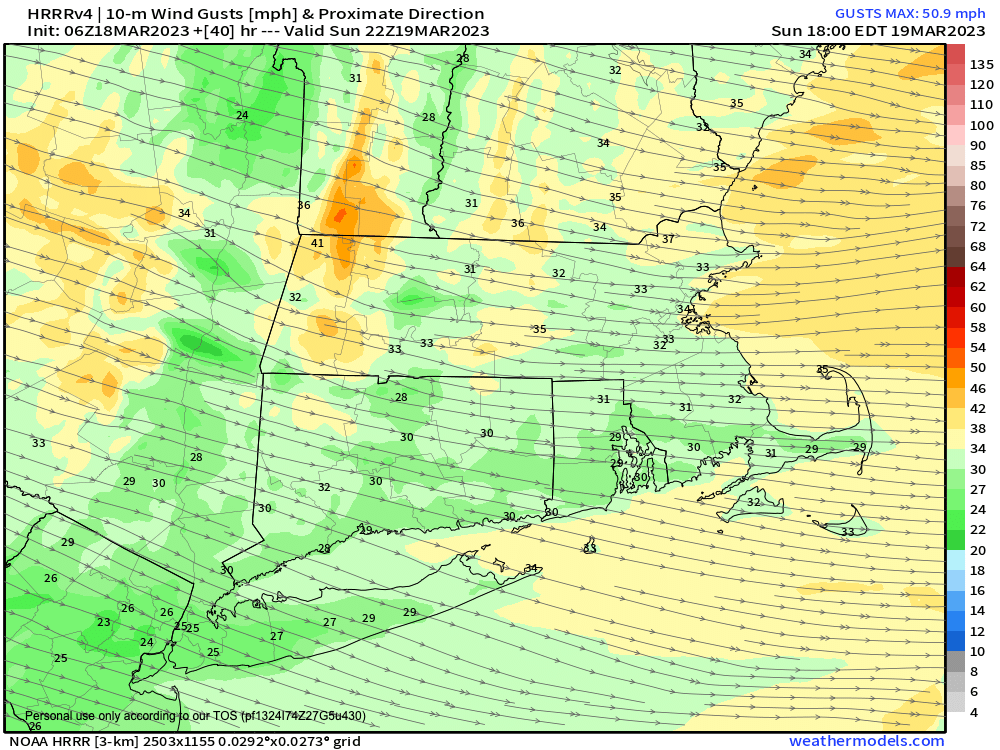
Westerly wind gusts 25-45mph Sunday
–> My Annual Support Goal = 4% of readers (1 in 25) donating any amount
–> 2023 Goal Progress = about halfway there
–> 2023 Member Drive ends 3/26
–> I’m still well short of my 4% reader goal
–> Any member or support level is appreciated
–> SecureSupportCLICK
———————-
Good morning everybody, even though we still have 1500 outages in southeast VT and 350 in the Berkshires from our late-season historic nor’easter, we’re firmly on the other side of a three-week active wintry pattern.
As such, conditions have turned a tad more pedestrian, so I’m going to deploy below a liberal scattering of my world-famous (and now patented in 93 languages) double–dashes. Remember, they’re not just for dinner anymore, so do enjoy this hearty digital breakfast of paired horizontal lines for your weather-perusing pleasure:
–It’ll be sunny and nice today, though a bit breezy as a cold front has cleared our region to the east
–Gusts may pick up to 25mph or so out of the west, and this will continue tonight, and increase Sunday
–Highs today will reach well into the 40s, but likely hang in the upper 30s to low 40s in far northwest/northern MA and SVT/SWNH due to thick snow pack
–It’ll be quite cold tonight with west winds picking up and gusting 20-30mph, along with a few snow showers possible and lows in the upper teens to low 20s
–This could drive wind chills down into the low 10s and maybe single digits for brief periods in the high terrain, so bundle up!
–Sunday is cold and blustery, but partly sunny with a few snow showers in the afternoon and highs only in the upper 20s to mid 30s
–West winds will gust between 25-45mph, so stay bundled! Chilly!
–Lows drop down into the low to mid 20s with winds slowly decreasing, and then we enter The Mildening
–Monday through Wednesday will feature a spring surge for sure, as sunshine develops with high pressure driving southerly flow into the region
–High temps will be in the 40s at first, and climb well into the 50s by mid-week with lows near freezing
–The next chance at rain is Thursday as a frontal system moves through, and then we’ll have to watch for another system over the weekend, which may start off wintry, but I will keep you updated on that potential
Have a great day, and if you rely on my work here, I’m asking you to reciprocate and contribute today to my annual support drive before next Sunday so I can continue this daily local weather reporting service throughout 2023 – I’m only halfway to the goal with just 8 days left, thank you.
———————-
BECOME A 2023 MEMBER / SUPPORTER BELOW(Options include Cards, PayPal, Venmo, or Check)