
Historic Nor’easter Pulling Seaward
–> New England weather is always changing
–> As it does, I want to continue to be there for you & yours
–> My Annual Support Goal = 4% of readers (1 in 25) donating any amount
–> 2023 Goal Progress = 53% have contributed to date
–> 2023 Member Drive ends 3/26, and I’m still well short of my 4% reader goal… could you help today? Any amount welcome
–> SecureSupportCLICK
———————-
Good morning everybody, we’ve still got some snow showers out there this morning, especially over southern VT and WMass, into CMass and northern CT.
This will be the case during the morning as everything continues to wind down, given that our captured, fully-phased, vertically stacked, closed low is now tracking east slowly out to sea.
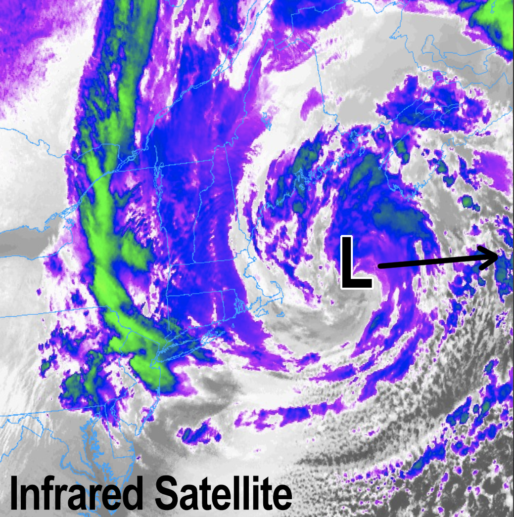
I attached an infrared satellite still from this morning, and it’s a gorgeous image of a deep storm pinwheeling away after dropping 1-3+ feet across much of the region where only relatively small elevation differences made HUGE changes in snow accumulations.
Even many in the valley floor from Springfield to Greenfield saw 5-10″ or so, which is quite an accomplishment in mid March for the Snow Lover’s Triangle of Disappointment!
There was one notable snow hole in easternmost Hampshire County: Ware, northern Belchertown, parts of Amherst seemed to only get 1-3″ or so. What goes up (intense snow bands that involved lifting/rising air) must come down (subsidence, areas of sinking air), and as I’ve said many times in the past, we can’t know where exactly that will set up.
For a while in eastern Franklin County, there was one there too that extended into areas like Athol, but those folks got additional snow last night.
Anyway, it’s a storm that will be remembered by many of us and images and in our memories, and unfortunately it caused a lot of tree carnage and damage from the weight of that super sopping heavy wet snow, which as I type has resulted in almost 60000 outages remaining across the region due to snow load issues.
Fortunately due to the storm’s loop keeping it a bit further east out over the ocean, the strongest winds did not come to pass and further exacerbate the problem, or we could have peaked as over 200000 outages rather than over 100000 outages during the height of the storm.
Before we continue with our upcoming weather details, let’s check a note from our Local Sponsor
~~~~~~~~~~~~~~~~~~~~~~~~~~~~~~~~
Dave Hayes The Weather Nut is Sponsored by Individual Community Members, Patrons & Tandem Bagel Company… No matter the weather, Tandem Bagel is always there for you at several valley locations to make your mornings brighter! With bagels baked fresh daily (including Gluten-Free options), house-whipped cream cheese, coffee, and tons of lunch options, Tandem is the perfect quick stop for lunch, breakfast, or a coffee and bagel to go. Find them in Easthampton, Northampton, Hadley, Florence, and West Springfield, or use their super-streamlined online ordering tool by visiting their website.
~~~~~~~~~~~~~~~~~~~~~~~~~~~~~~~~
Moving forward, leftover flurries and snow showers will decrease this morning with our storm pulling away, the pressure gradient will increase and northwest winds will gust 30-50mph, producing new outages, so we’re not out of the woods yet on that score.
Skies will be mostly cloudy with some partial sunshine later this afternoon. Highs will reach the low to mid 30s in the high terrain and upper 30s to low 40s in the valley south and east.
It will be blustery this afternoon, and will continue blustery tonight with lows in the low to mid 30s as northwest winds gust 25-40mph.
Any melting that happens today will freeze right back up over night, so watch for slippery areas in the morning, especially where deep snowpack continues.
For Thursday, the storm is completely out of our region with partial sunshine in the morning as high pressure tracks south of us.
This will put us into southerly flow with highs rising into the upper 30s to mid 40s, with clouds increasing slowly during the afternoon. Lows will dip to near freezing Thursday night as skies become overcast.
———————-
BECOME A 2023 MEMBER / SUPPORTER BELOW(Options include Cards, PayPal, Venmo, or Check)
———————-
On Friday, a storm will be set to track to our northwest at night, and as such will push a warm front toward the region.
Warm frontal scattered showers will develop in the afternoon and evening, but a washout is not expected.
Highs will reach well into the 40s with lows in the mid to upper 30s.
A cold front from the storm passing to our north swings through Saturday with more scattered showers, and highs in the low to mid 40s.
Behind the front, it will cool down quite a bit with lows in the low to mid 20s, followed by a rather blustery and colder Sunday with highs only in the low to mid 30s.
A few snow showers may pop due to instability, and it will breezy out of the west, with lows in the upper teens to mid 20s.
Early next week looks like fair weather with partly to mostly sunny skies and increasing temps reaching the low to mid 40s by Tuesday.
Have a great day, and if you rely on my work during big storms like yesterday, or every day, please contribute to my annual support drive before 3/26 so I can continue this daily local weather reporting service throughout 2023, thank you.
———————-
BECOME A 2023 MEMBER / SUPPORTER BELOW(Options include Cards, PayPal, Venmo, or Check)
———————-