
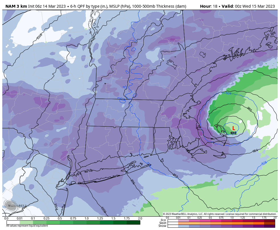
972mb low off of Cape Cod this evening
–> New England weather is always changing
–> As it does, I want to continue to be there for you & yours
–> My 2023 Support Goal = 4% of readers (1 in 25) donating any amount
–> 2023 Goal Progress = 49% have stepped up to date
–> 2023 Member Drive ends 3/26, and I’m well short of my 4% reader goal
–> SecureSupportCLICK
———————-
Good morning everybody, I imagine some only saw my 7pm report, but I posted again after 10pm stating that based on maximized dynamic cooling observed last night as precipitation picked up in intensity that I was concerned for central and southern valley snow accumulations of a coating to 3″ or by morning, and here we are for the most part.
Clearly, this change to snow happened many hours before it was expected to, but that is the nature of dynamic cooling events like this – you can’t predict how one or two degrees aloft one way or the other is going to impact precip type in marginal events like this.
I’ve received the following snow reports:
–Florence: 4″
–Shutesbury: 8″
–Plainfield: 12″
–Sandisfield: 15″
How much snow do you have where you live this morning? Please post your reports below.
Before we continue into the details below…
~~~~~~~~~~~~~~~~~~~~~~~~~~~~~~~~
A NOTE FROM OUR LOCAL SPONSOR:
Dave Hayes The Weather Nut is Sponsored by Individual Community Members, Patrons & Tandem Bagel Company… No matter the weather, Tandem Bagel is always there for you at several valley locations to make your mornings brighter! With bagels baked fresh daily (including Gluten-Free options), house-whipped cream cheese, coffee, and tons of lunch options, Tandem is the perfect quick stop for lunch, breakfast, or a coffee and bagel to go. Find them in Easthampton, Northampton, Hadley, Florence, and West Springfield, or use their super-streamlined online ordering tool by visiting their website.
~~~~~~~~~~~~~~~~~~~~~~~~~~~~~~~~
MORNING UPDATE: SNOW AND RAIN
Heavy snow is falling across many areas of the WMass region this morning, with some lulls in southwest MA and northern CT, with rain continuing in northeast CT as well as southernmost and southeastern Worcester County (though that appears to be changing based on recent radar trends).
Otherwise, it has been snowing all night long, and travel is slippery, visibility low in places, and outages are mounting.
It is plenty cold aloft for snow to continue today, based on steady/heavy precipitation.
However, as the morning light arrives, our precip may become more scattered and lighten up a bit this morning for areas in the central/southern Pioneer Valley (Northampton south to Hartford).
This is good, because we have about 20000 outages from snow load alone in WMass alone, and almost 40000 across the greater WMass region (SVT, SWNH, WMASS, CMASS, and NCT).
This could result in the valley mixing with rain during lighter intensity precip (or drizzle), but barring that, periods of snow should continue, as this second phase of the storm runs its course and the heavy precipitation bands pivot into a more east to west axis vs. south to north axis as the upper low begins to capture the surface low.
This process will also generate more precipitation anew by late morning into the afternoon and evening before it winds down.
It is during this third/final phase where cold-enough air will be pulled southeastward through the region, and should flip to snow even in southeastern parts of Hampden County, northeast CT and southern Worcester County.
I will continue to update all morning, noon and night until I pass out, so please stay tuned for updates, I’ll be here until it winds down tonight!
WIDESPREAD POWER OUTAGES POSSIBLE
Ever since this storm came on to my radar (pun intended) I’ve been concerned for pockets of widespread outages, which I’ve conveyed to you all.
We’ve already got about 37,000 outages in SVT, SWNH, WMass, CMass, and northern CT from snow loading issues due to wet snow alone.
I am concerned that those will continue this morning in the Berkshires, western hilltowns and SVT as the heavy snow bands pivot through that region.
But my biggest concern is when the wind comes, which is when we could see over 100,000 outages across the region.
Northeast winds will pick up and gust 25-45mph by mid day or so, and then by evening should be gusting 35-55mph, with a max wind possible over northern Worcester County into southwest NH.
So if you have power this morning in any of those mentioned areas, make sure you are ready for the power to go out, as best you can, is my advice.
———————-
BECOME A 2023 MEMBER / SUPPORTER BELOW(Options include Cards, PayPal, Venmo, or Check)
———————-
SNOW TOTALS ARE COMING UP…
THE PIONEER VALLEY OF WMASS
–3-9″ from Hartford up to Springfield and Northampton in the valley floor up to Deerfield, upper range the more north you go
–6-12″ in central and eastern Franklin County, except some hilltowns like Shutesbury, Wendell and others that may see over 12″
NORTHERN CONNECTICUT
–3-7″ in Tolland and Windham County CT, though some areas could see over 7″ depending on final phase of this storm
–6-12″ in western Hartford County into Litchfield County, with 12-20″ possible in northeast Litchfield
BERKSHIRES, WESTERN HILLTOWNS, SVT
–7-14″ in western Berkshire County from Pittsfield/Dalton south to Great Barrington
–15-25″ in the rest of northern and eastern Berkshire County, and the western hilltowns of Franklin, Hampshire, and Hampden Counties
–15-30″ in the southern Greens
–8-14″ in southern VT over the Bennington and Brattlelboro lowland regions/valleys there
EASTERN HAMPDEN, CENTRAL MA AND SOUTHWEST NH
–5-10″ in the eastern Hampden County highlands (Monson, Palmer, Brimfield), as well as southern Worcester County
–10-20″ in northern CMass and southwest NH
That’s how I see it as of this morning, I will update as the day goes on.
Have a great day, and please stay tuned for updates, and please support my work before 3/26 so I can continue this daily local weather reporting service throughout 2023, thank you.
———————-
BECOME A 2023 MEMBER / SUPPORTER BELOW(Options include Cards, PayPal, Venmo, or Check)
———————-