
Major Nor’easter for Tuesday
How much did you get, and can you post some pics?
For the rest of the morning, we’ll see snow showers wax and wane with perhaps some additional light accumulation of a coating to maybe an inch in the higher elevations in a burst or two, but after mid-morning, we should start to taper down, as the storm pulls away to the east while it deepens further.
A light north wind develops with highs in the upper 30s to low 40s, and lows in the upper teens to mid 20s as skies start to clear out with high pressure nudging into the region, setting us up for a sweet, at least partly sunny Sunday with highs in the low to mid 40s.
Clouds increase Sunday night with lows in the mid to upper 20s.
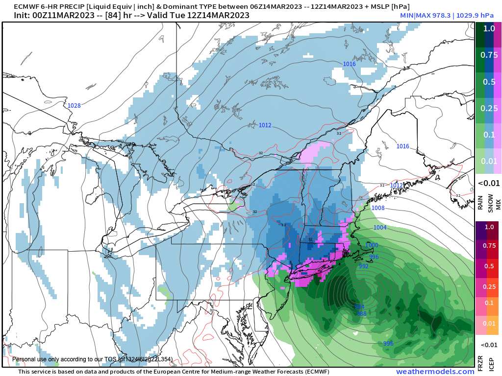
NOR’EASTER SETUP
As this happens, a strong upper level trough will dig southeast into the Ohio/Pennsylvania region and transition from a neutral tilt (i.e. south to north in its axis), to a more negative tilt with time (i.e. more south-southeast to north-northwest in its axis).
As this northern energy moves into place, a juicy piece of southern energy will be tracking rapidly east then east-northeast toward the North Carolina coastline along the upper trough’s southern flank.
This surface low will classically tap some Gulf of Mexico moisture during its transit through the Deep South, and then when it hits the Carolina coastline will tap Atlantic moisture as it is drawn north-northeastward by the negatively-tilting upper low.
These two features are anticipated to phase/merge, and that merger will deepen the surface low as it is guided straight toward Cape Cod and the Islands, potentially leading to bombogenesis (a 24 millibar drop in surface pressure in 24 hours or less).
At the same time we’ll have blocking high pressure out over Newfoundland, so this storm is not going to just run through the Cape and out into Atlantic Canada.
No, this storm is going to slow down and deepen near Cape Cod, and become a major late-season nor’easter!
It will slow down, it may stall for a time, and it may even do a loop de loop, retrograding west for a time before pulling back east and slowly heading out to sea.
DYNAMIC COOLING WILL BE KEY
All that’s missing is the super cold Arctic high pressure to our north, which gives me some pause in terms of snowfall generation, but a storm of this magnitude *should* be able to generate its own cold air through a process called dynamic cooling.
Dynamic cooling occurred classically in the April Fool’s Blizzard of 1997, another heavy wet snow storm that dumped 1 to 2 feet across southern New England, and occurs when it’s cold enough aloft and a heavy/steady enough precip shield pulls that cold air down to the surface, allowing snow to reach the ground and accumulate.
Having laid that out, I am going to delivery via double–dashes some info about how I feel this will play out and what I’m looking at it, and then go into a few other points before wrapping up.
————————————–
WHAT WILL I GET WHEN I JOIN DHTWN’s
2023 SUPPORT NUTWORK TODAY?
–> COMMITMENT: You get a humble human who intends on delivering hyper-local, timely and educational weather reports with humility, humor, gratitude, and big-picture perspective to help you plan your days optimally.
–> SecureCLICK
——————-
MONDAY
–Temps will be mild and precip will be lighter on Monday, so this day looks like a strictly elevation-dependent snow day
–Highs will be in the mid to upper 30s
–Some light accumulations are possible by sunset in the high terrain
–Valleys and lowlands should see rain or rain/snow mix, especially during light precip periods
–At night, we will cool down and this is when the storm draws closer and precip intensity should begin to increase
TUESDAY
–At some point during the night into Tuesday dawn, many of us could be switching over to all snow, with moderate to heavy snow by Tuesday morning
–Big storms like this do weird things with their precip shields, and a lot of times you get banding of precipitation
–With a marginal thermal event like this, when it’s precipitating heavily it is snowing heavily, and when you get in a lighter band, it could go to rain/snow mix, and not accumulate much
–Also with the high mid-March sun angle and temps in the low to mid 30s, accumulation is not as efficient, meaning it doesn’t stack up as well or quickly
–Anyway, Tuesday into Tuesday night is the brunt of the storm and northeast winds wind gusts will pick up to 30-45mph the way it looks now
–Moderate to heavy snow will fall at times, and outages could start developing by Tuesday afternoon and night
WEDNESDAY
–The storm will be starting to pull away by this time and snow should become lighter and more intermittent
–However, a deformation zone may form over CMass and northeast CT, prolonging accumulating snow there Wednesday morning
EARLY AMOUNTS CALL
This is a very early call, but right now this seems given the potential for compaction of wet snow Tuesday, high sun angle, marginal temps and other issues, we could see an 8-16″ type wet snow accumulation, and I wouldn’t be surprised if a few places in the western hilltowns, eastern Berkshires and southern VT saw 2 FEET of snow from this system, as snow would be a bit drier there.
OUTAGES
Again, the combination of heavy wet snow and wind is not a good one, and I would expect at least scattered outages, and if things really came together, we could see pockets of numerous outages in the high terrain, so hilltowners and mountain dwellers would do well to sure up supplies and resources (though most of you are inherently prepared in life!).
We would all do well to expect an outage on Tuesday or Tuesday night and make sure phones and devices are charged, car is gassed up, and you have candles and flashlights at the ready.
This is a dynamic looking storm system, and surprises occur. I will do my best to navigate you all through this upcoming potentially major nor’easter, so stay tuned for updates as the days pass into next week!
Have a great day… “Dave is constantly reviewing and updating with attention to all of our different little weather zones which can vary drastically. Plus, I love that the community of followers help each other know what road conditions and weather effects are in each location in real time! A truly community-centered service!!” –Taiko C.
–> I’m still short of the goal (42%) of 4% of you donating w/ 15 days left in this drive
–> Your Contributions Today Help Sustain this Community Weather Resource
–> Click this secure link to select from many support options, thanks!