
MY BELIEF
–> My Belief is that if you depend on my work, and are able, you’ll help sustain it through 2023 by becoming a Support Nutwork Member (with gifts) or Supporter (no stuff) at any level at the secure link below…
–> SecureSupportClick
——————-
TABLE OF CONTENTS:
–DHTWN Reminder (Be Nice)
–Weekly Nutshell (Quick impact list)
–Sponsor Note (Tandem Bagel Co.)
–NWS Alerts (Advisories, Warnings, Watches)
–Celestial Data (Sun/Moon info)
–Regional Summaries (Quick in/out details)
–Morning Discussion (More Details)
~~~~~~~~~~~~~~~~~~~~~~
DHTWN REMINDER: It doesn’t take much to do a nice thing for somebody that you don’t know.
~~~~~~~~~~~~~~~~~~~~~~
DAVE’S WEEKLY WEATHER NUTSHELL
–A nice sunny start begets a gray cloudy finish today
–Highs well into the 40s with lowering humidity into the afternoon
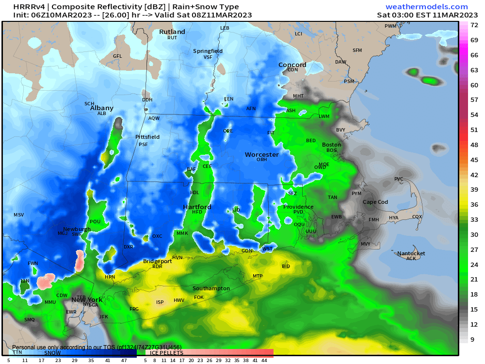
–A storm approaches OH and PA this afternoon, and develops east of the Delaware coast tonight, tracking east and out to sea
–This spreads rain and snow into SVT, WMass and northwest CT between 7-10pm, lasting all night
–Likely we see snow in the high terrain and rain in the valleys to start, then we should flip to snow in most places with time
–Coating to 2″ for the CT River Valley points east in MA and CT, as well as SVT/SWNH (and western Berkshire County) with 2-4″ in northwest CT, southeastern Berkshires and western hilltowns of Hampshire and Hampden County
–Snow quits Saturday morning, then cloud and seasonable
–Sweet sunny Sunday will be lovely in the 40s
–Major late-season long-duration wet snow Nor’easter possible with wind, outages, rain mix at times, very stormy look for Monday night through Tuesday night, but before we jump into the weather discussion/details below, let’s check a note from our local and delicious sponsor, #TandemBagelCo, with their newest location in West Springfield, MA.
~~~~~~~~~~~~~~~~~~~~~~
A NOTE FROM OUR SPONSOR:
Dave Hayes The Weather Nut is Sponsored by Individual Community Members, Patrons & Tandem Bagel Company… No matter the weather, Tandem Bagel is always there for you at several valley locations to make your mornings brighter! With bagels baked fresh daily (including Gluten-Free options), house-whipped cream cheese, coffee, and tons of lunch options, Tandem is the perfect quick stop for lunch, breakfast, or a coffee and bagel to go. Find them in Easthampton, Northampton, Hadley, Florence, and West Springfield, or use their super-streamlined online ordering tool by visiting their website.
~~~~~~~~~~~~~~~~~~~~~~~~~~~~~~~~
***DHTWN DAILY WEATHER REPORT***
~~~~~~~~~~~~~~~~~~~~~~~~~~~~~~~~
NATIONAL WEATHER SERVICE ALERTS
–Winter Weather Advisories are up for Litchfield County CT tonight
DAILY CELESTIAL (STAR):
–OUR STAR ROSE AT: 6:11am this morning
–OUR STAR WILL SET AT: 5:50pm this evening
–TOTAL DAYLIGHT TIME: 11 hours and 39 minutes
***DAYLIGHT SAVING TIME ENDS TOMORROW, CLOCKS GO FORWARD ONE HOUR TOMORROW NIGHT***
NIGHTLY CELESTIAL (MOON):
–OUR MOON WILL RISE AT: 9:16pm this evening
–OUR MOON WILL SET AT: 7:59am tomorrow morning
–MOON RISE DIRECTION: East-Southwest
–MOON SET DIRECTION: West-Southwest
–MOON PHASE: Waning Gibbous (91.6%)
~~~~~~~~~~~~~~~~~~~~~~~~~~~~~~~~
DAILY TERRESTRIAL
ZONE 1 – Northern Region
(Southern VT, Southwest NH)
–High Temps: Upper 30s to Low 40s
–Low Temps: Mid 20s to Low 30s
–Winds: Light and variable
–Sky Cover: Sunny early, clouding up with time
–Precipitation: Dry today, light snow tonight, C-2″ possible
ZONE 2 – Central Region
(Western MA, North-Central MA, Northern Litchfield CT)
–High Temps: Low to Mid 40s
–Low Temps: Upper 20s to Low 30s
–Winds: Light and variable
–Sky Cover: Sunny early, clouding up with time
–Precipitation: Dry today, rain and snow after sunset, changing to light to moderate snow overnight, C-2″ most areas, but 2-4″ in southeast Berkshires, southwest WMass hilltowns, and northern Litchfield County
ZONE 3 – Southern Region
(South-Central MA, Northern CT)
–High Temps: Mid to Upper 40s
–Low Temps: Low 30s
–Winds: Light and variable
–Sky Cover: Sunny early, clouding up with time
–Precipitation: Dry today, rain and snow after sunset, changing to light to moderate snow overnight, C-2″ many areas, but 2-4″ in southern Litchfield County possible, Hartford Metro may remain snow/rain mix all night with no accumulation
~~~~~~~~~~~~~~~~~~~~~~~~~~~~~~~~
LET’S STAY CONNECTED
Visit this page on my website on Staying Connected
~~~~~~~~~~~~~~~~~~~~~~~~~~~~~~~~
MORNING DISCUSSION
Good morning everybody, March and this Winter are potentially going out like a lion with a minor little whiff of a snowfall tonight that may serve as the appetizer for what could become a powerful, long-duration, multi-hazard major nor’easter merging with upper level energy to our west, with a surface low tracking up to Cape Cod and blasting us with rain, heavy wet snow, wind, and many potential outages.
Heavy wet snow and wind are probably the worst combination of winter weather, right on par with freezing-rain-based ice storms in terms of impacts to travel and infrastructure.
I’m not saying this comes to pass, we have at least 72 hours of data analysis and monitoring to go before this system begins to take shape on our collective doorstep, but let’s just say the hairs on the back of my neck have begun to lift outward a bit as I continue to watch the trends and guidance come in.
I recognize my own meteorological excitement, so I’m working hard on remaining calm and communicating these potential impacts in a metered manner, but if this all comes together, we could have a real problem on our hands related to numerous power outages, especially in the high terrain of Worcester County and in the western hilltowns, Berkshires, and southern VT, so please stay tuned to future updates which will be at least twice daily, and like three times on Sunday (once in the morning, once in the early afternoon, and a final one Sunday evening, as I have plans that later afternoon).
The rest of this report will be brought to you by the fine folks over at Double–Dash Incorporated, purveyors of finely paired digitally-rendered horizontal marks positioned halfway above the text baseline since amber screens joined forces with MS-DOS computing systems in the 80s and 90s.
SUMMARY
–Enjoy this sunny start, as a cloudy finish is on the way
–Highs will reach the upper 30s to mid 40s today, maybe upper 40s in northern CT
–Clouds will build, and humidity will decrease, which is important for getting the valley to snow tonight
–A storm will track into western PA and redevelop off the Delaware coastline tonight, tracking east and out to sea
–The associated upper low (all storms have a surface, mid-level and upper-level low center: storms are VERTICAL) will wobble over southwest CT and NYC Metro overnight
–This brings rain and snow into WMass and western CT between 7-10pm tonight
–Any rain in valleys should flip to snow overnight via evaporative cooling, but may stay rain/snow mix from Springfield to Hartford, will be on the borderline
–Snow may fall moderately at times in northwest CT and far southwest MA, with 2-4″ in that area, and a coating to 2″ in the rest of the greater WMass region
–All in all, a light storm with low temps either side of 30º
–Morning snow and rain showers Saturday gives way to drying and highs in the 35-40º range with mostly cloudy skies
–Northerly and northwesterly cooling flow pulls lows down into the the low to mid 20s Saturday night
–Sunday is lovely, highs low to mid 40s, light southerly flow, sunny, lows upper 20s to low 30s with clouds building
–Monday through Tuesday night is looking very stormy right now
–There are many details to be worked out and over the weekend I will go into all of the factors I’m looking at and considering
–One issue will be when precip is light it may rain, especially on Monday, in the valley, with snow in the high terrain
–Main brunt of storm looks to be Monday night into Tuesday as an upper low over the southern Great Lakes phases with a surface low rounding its southern flank and passing off of the VA coast
–This upper low would guide the surface low northeast up toward Nantucket
–This storm likely slows down due to blocking high pressure northeast
–It may stall, do a loop like the Blizzard of ’78, all while deepening into potent nor’easter
–If this comes to pass, over a foot of heavy wet snow is possible with winds gusting to 40mph out of the northeast
–We may feeling effects into Wednesday
–Please stay tuned for updates as the days move forward, and if you’d like to support my work and service, please remember…
PLANTS THAT WE WATER KEEP GROWING
–> When 4% of readers “water” my work, I can keep it going
–> I’m currently just 41% of the way to that goal
–> My 2023 Member Drive ends on 3/26, in 16 days
–> Anything helps: $10, $35 or $100+ one time, or smaller $3, $6, or $10 monthly
–> Click the secure link below to select from Membership or Support options
–> SecureCLICK
——————-
BE KIND
“Hello babies. Welcome to Earth. It’s hot in the summer and cold in the winter. It’s round and wet and crowded. On the outside, babies, you’ve got a hundred years here. There’s only one rule that I know of, babies: Goddamn it, you’ve got to be kind.”
–Kurt Vonnegut