
SECURELY BECOME A 2025 WEATHER NUT SUPPORTER TODAY
–> When 4% of readers support at any level, it
ensures this community weather resource persists
(We’re about 61% towards that goal)
~~~~~~~~~~~~~~~~~~
TABLE OF CONTENTS
* Daily Celestials (Sun/Moon Data)
* Sponsor Section
* Morning Discussion
* TIP: Scroll to your section, or read more
~~~~~~~~~~~~~~~~~~~~~~
YOUR DAILY CELESTIALS
~~~~~~~~~~~~~~~~~~~~~~
STAR:
–OUR STAR ROSE AT: 6:24am this morning
–OUR STAR SETS AT: 5:40pm this evening
–TOTAL DAYLIGHT TIME: 11 hours and 16 minutes
MOON:
–OUR MOON ROSE AT: 7:14am this morning
–MOON RISE DIRECTION: East
–OUR MOON SETS AT: 7:58pm tonight
–MOON SET DIRECTION: West
–MOON PHASE: Waxing Crescent (3.4%)
~~~~~~~~~~~~~~~~~~~~~~
>>> A NOTE FROM OUR WEEKEND SPONSOR <<<
Dave Hayes The Weather Nut is Sponsored by Individual Community Members, Patrons, and Gerard, Ghazey & Bates, P.C.
GGBPC is a Northampton-based law firm and is the area’s premier estate and tax planning provider. The firm specializes in Estate Planning, Elder Law, and Tax Law, so be sure to contact GGBPC today to see how they can help you.
Simply click this link to their secure website.
~~~~~~~~~~~~~~~~~~~~~~
YOUR MORNING DISCUSSION
~~~~~~~~~~~~~~~~~~~~~~
Good morning folks, first off I want to thank all of the folks that have stepped forward to support my work and this resource recently.
I am hopeful that I will be about 2/3rds of the way to my 4% reader support goal by early this coming week with 2 weeks remaining in my 11th annual Support Drive for 2025.
It’s been a long decade-plus journey and with enough folks stepping forward (even with modest contributions of $10 one time or $3/month this year) can enable me to keep this as a public-facing community resource for all on an almost-daily basis.
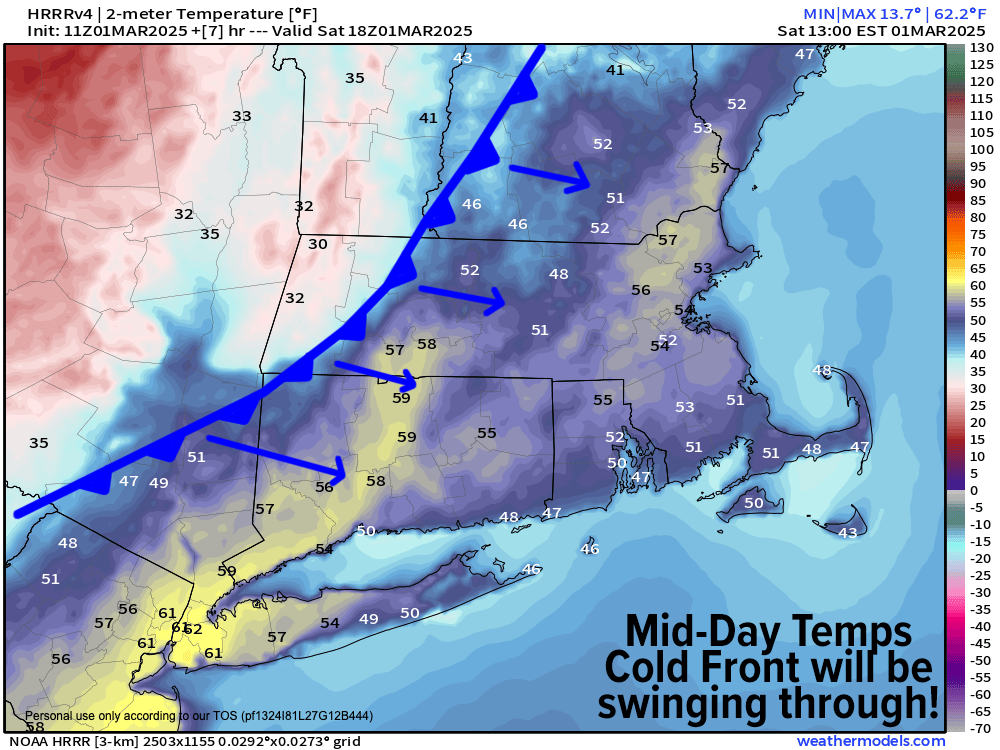
As for our weather this weekend, we have a wild day ahead, to be honest, but not in terms of precipitation (though a few heavy rain or snow showers are possible as a sharp cold front whips through the region between Noon and 3pm today).
Instead, we’re going to witness winds that veer from southerly gusts up to 20mph or so this morning, around to the west-northwest and kicking into the 30-50mph range as temps plummet some 40 degrees between noon and 6am Sunday morning which will most certainly remind you of a line in James Taylor’s famous song, Fire and Rain (you know the one!)
High temps under a mix of sun and clouds should only climb into the upper 30s to mid 40s by late morning in northwest MA and SVT/SWNH, as the front will be moving right through the VT/MA border by mid-day into early afternoon.
Elsewhere in the greater WMass region, high temps should come up well into the 40s, with areas from Northampton down through Hartford and points east into southern CMass and northeast CT reaching into the upper 40s to mid 50s (with some brief upper 50s in the Hartford area possible).
By Noon to 3pm, however, and from west to east, a strong cold front will be slicing through the greater WMass region and should be accompanied by some scattered (and potentially heavier and gusty) low-elevation rain showers and/or high-elevation snow showers.
West-northwest wind gusts should also pick up sharply as the front moves through, gusting 30-50mph at times, highest in the high terrain.
As this happens, temps will collapse into the 20s in the Berkshires by mid to late afternoon, destined to bottom out into the single digits and teens with WNW gusts persisting into the 20-35mph range at times overnight.
This will drop our wind chills down into the single digits above zero in the valley, and down as low as -10º in the high terrain, so bundle up if you are out tonight or up early Sunday morning, as winter is roaring back for a couple of days!
Sunday and Monday will calm down wind-wise as strong high pressure continues to press east towards our region, resulting in mostly sunny skies both days and mostly clear nights.
Highs Sunday will reach the mid teens to mid 20s with lows in the single digits, and Monday’s highs will climb into the mid 20s to low 30s with lows in the low teens.
Said high pressure will track off of the Mid-Atlantic coast to our south, and result in a southwesterly flow by Tuesday, which will produce milder highs into the low to mid 40s under partly sunny skies, with lows in the mid 30s.
It does look like we have a potentially strong rainstorm with some wind coming sometime Wednesday into Thursday, but the timing of rain onset is uncertain right now.
My best idea for now is that rain arrives by Wednesday afternoon, falling through the night into Thursday morning before tapering off.
Highs Wednesday and Thursday should reach up into the upper 40s to mid 50s with pretty strong southerly gusts on Wednesday, but I will refine this part of the forecast we get closer.
It appears that we will cool down behind that storm with some possible upslope snow showers in the Berkshires on Thursday night into Friday morning with mostly fair weather to end the week.
Have a great day, and if you find my hyperlocal and interactive reporting work is helpful to you, I’d be grateful for your help today to support it tomorrow and through 2025… thank you so much for your readership and support, Dave Hayes.
SECURELY BECOME A 2025 SUPPORTER TODAY
–> When 4% of readers contribute at any level,
this community resource can remain active & vital:
(Secure options include Cards, PayPal, Venmo, Check)
“Follow your bliss and the universe will open doors for you where there were only walls.”
― Joseph Campbell