
TABLE OF CONTENTS
* Daily Celestials (Sun/Moon Data)
* Sponsor Section
* Morning Discussion
~~~~~~~~~~~~~~~~~~~~~~
YOUR DAILY CELESTIALS
~~~~~~~~~~~~~~~~~~~~~~
STAR:
–OUR STAR ROSE AT: 5:14am this morning
–OUR STAR SETS AT: 8:24pm this evening
–TOTAL DAYLIGHT TIME: 15 hours and 10 minutes
***We’re in the Peak Light Period of 2025***
MOON:
–OUR MOON RISES AT: 6:20pm this afternoon
–MOON RISE DIRECTION: East-Southeast
–OUR MOON SETS AT: 3:36am tomorrow morning
–MOON SET DIRECTION: West-Southwest
–MOON PHASE: Waxing Gibbous (92.4%)
~~~~~~~~~~~~~~~~~~~~~~
>>> A NOTE FROM OUR WEEKEND SPONSOR <<<
Dave Hayes The Weather Nut is Sponsored by Individual Community Members, Patrons, and Gerard, Ghazey & Bates, P.C.
GGBPC is a Northampton-based law firm and is the area’s premier estate and tax planning provider. The firm specializes in Estate Planning, Elder Law, and Tax Law, so be sure to contact GGBPC today to see how they can help you.
Simply click the following link to their secure website.
~~~~~~~~~~~~~~~~~~~~~~
YOUR MORNING DISCUSSION
~~~~~~~~~~~~~~~~~~~~~~
Good morning everybody, we’ve got patchy fog, dense in spots, that has formed overnight, and so visibility will be down for some until about mid-morning, so take it easy on the roads if you’re in a dense patch.
The fog is also combining with some influence from the Canadian wildfires, so even though Air Quality Alerts aren’t hoisted, Air Quality Indices are over 100 in some cases this morning, especially in the valley.
We should see some partly sunny skies to develop today with highs rising into the 70s, as high pressure will be nudging into the region, but with a weak wave tracking northeast towards the southern coast as mentioned yesterday, I can’t rule out a few isolated showers later today and overnight, and potentially on Monday as well.
Having said that, we should be mostly dry over these next couple of days. Lows tonight will dip into the mid to upper 50s with highs tomorrow in the upper 60s to mid 70s.
After a few periods of Monday sunshine, clouds will be on the increase as a warm front starts to push toward New England.
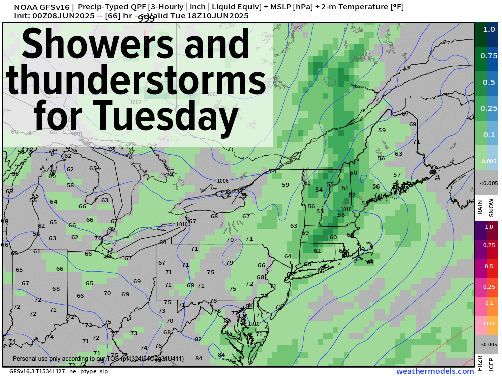
By late Monday night, more shower potential will increase with lows in the 50s, and by Tuesday we’ll be dealing with more numerous showers by morning.
Temps will cool down as well, hanging in the upper 60s to low 70s ahead of another frontal boundary that will swing through the region by later Tuesday, likely producing showers and thunderstorms as it swings through.
After that system impacts us, we will hopefully enjoy a few days from Wednesday through Friday that will be warmer with highs well into the 70s Wednesday, reaching into the low to mid 80s by late week under partly to mostly sunny skies.
We surely deserve it! Have a great rest of your weekend!
“Follow your bliss and the Universe will open doors for you where there were only walls.”
― Joseph Campbell