
~~~~~~~~~~~~~~~~~~~~~~
TABLE OF CONTENTS
* Daily Celestials (Sun/Moon Data)
* Sponsor Section
* Morning Discussion
* TIP: Scroll to your section, or read all
~~~~~~~~~~~~~~~~~~~~~~
YOUR DAILY CELESTIALS
~~~~~~~~~~~~~~~~~~~~~~
STAR:
–OUR STAR ROSE AT: 5:18am this morning
–OUR STAR WILL SET AT: 8:30pm this evening
–TOTAL DAYLIGHT TIME: 15 hours and 12 minutes
MOON:
–OUR MOON WILL SET AT: 3:12pm this afternoon
–MOON SET DIRECTION: West-Northwest
–OUR MOON WILL RISE AT: 1:35am tomorrow morning
–MOON RISE DIRECTION: East-Northeast
–MOON PHASE: Waning Crescent (32.4%)
~~~~~~~~~~~~~~~~~~~~~~
>>> A NOTE FROM OUR WEEKEND SPONSOR <<<
Dave Hayes The Weather Nut is Sponsored by Individual Community Members, Patrons, and Gerard, Ghazey & Bates, P.C. GGBPC is a Northampton-based law firm regarded as the voice of pragmatic and well-reasoned estate planning, elder law and tax guidance in Western Massachusetts. The firm specializes in estate planning law, and expertly handles other matters such as Elder Law, Tax Law, as well as Real Estate purchase, sales, and refinance transactions. Contact GGBPC today to see how they can help!
~~~~~~~~~~~~~~~~~~~~~~
YOUR MORNING DISCUSSION
~~~~~~~~~~~~~~~~~~~~~~
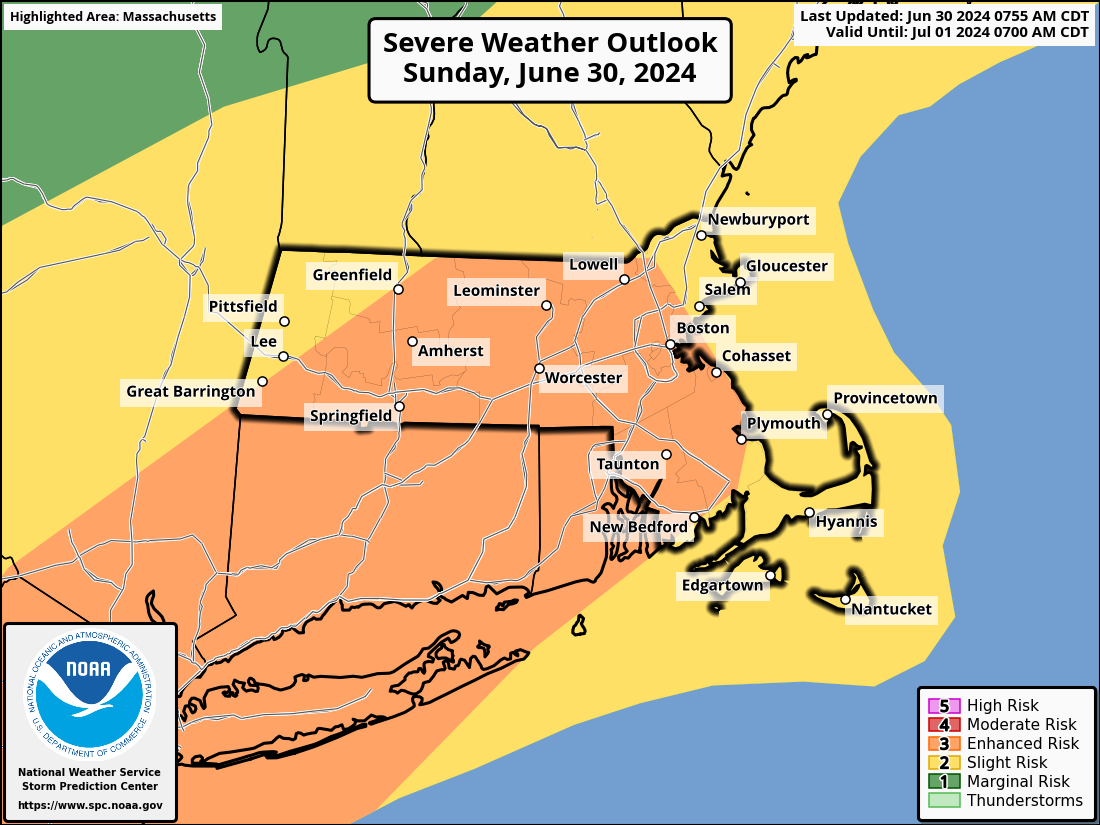
9:15AM UPDATE: The Berkshire storm dissipated rapidly, with some showers translating into the northern Berkshires and SVT… surface heating will maximize which has contributed to SPC raising an enhanced Level 3 of 5 risk for severe thunderstorms this afternoon, I am concerned for damaging straight line wind, folks, so please stay tuned and I will update again around noon before severe weather impacts potentially commence in the region…
Original report… Good morning folks, it sure is much more humid waking up today! This moisture-rich environment when combined with high temps expected to rise well into the 80s will increase our surface instability AND the regional low level lapse rates (gradient of temperatures from warmer surface to colder sky).
When you combine this with an incoming cold front that will force air to rise, in an already buoyant environment, and mix that with strong wind shear that is moving into the region ahead of the cold front, you get a recipe for strong to severe thunderstorms, which is what we’ll likely see between 1-5pm today.
Before that, we do have some morning showers with thunder that will push into the Berkshires by about 9am, and some gusty winds up to 40mph will be possible.
But it is behind that small line where we’re already seeing sunny breaks out in New York state, and that will allow heating of our surface in the later part of the morning and very early afternoon to help support thunderstorm development between 1 and 5pm or so.
In fact, there may be a second line that tries to fire with the actual cold front, with more showers and stronger storms possible into the early evening (though that line would be more in southern MA and northern CT.
The main threats today will be damaging straight line winds and larger hail, though I cannot rule out an isolated tornado in any super cells that may form out ahead of the cold front.
Flooding is possible as well, but less of an expected impact compared to the wind risk.
Everything clears out of here tonight after the cold front comes through, and lows will drop into the mid to upper 50s.
For tomorrow, the upper low that’s associated with the surface low tracking north of us today that will drag its cold front through our region with this expected thunderstorm activity will pass into New England with a cold pool of air aloft.
This will destabilize the atmosphere, but in a gentler way that will encourage scattered showers to form at times on Monday with highs in the 70s.
A Gentler Destabilization: a book on Dave Hayes’s middle-aged version of nutcakery, not in stores now.
Lows drop to either side of 50º on Monday night under mostly clear skies, and then we land into a pair of beauties for Tuesday and Wednesday with highs in the low to mid 80s, and lows in the upper 50s to low 60s.
Some showers will be possible Wednesday night into the 4th of July, with the chance for showers continuing through late week into the weekend as highs come up into the mid to upper 80s with more humid conditions.
I’ll sort and parse out the holiday details starting tomorrow, but for now, I am focused on our severe weather threat today, and will be in the saddle all day long monitoring development and updating you with new reports on this page, so please stay tuned. Have a great day!
HAIKU OF THE DAY:
More severe weather
Wind bags, ice rocks possible
Shelter is golden
“Follow your bliss and the universe will open doors for you where there were only walls.”
― Joseph Campbell