
~~~~~~~~~~~~~~~~~~~~~~
TABLE OF CONTENTS
* Daily Celestials (Sun/Moon Data)
* Sponsor Note
* Join My Newsletter (& get my Top12WMassStorms ebook!)
* Morning Discussion
* TIP: Scroll below for sections, or read all
~~~~~~~~~~~~~~~~~~~~~~
YOUR DAILY CELESTIALS
~~~~~~~~~~~~~~~~~~~~~~
STAR:
–OUR STAR ROSE AT: 5:17am this morning
–OUR STAR SETS AT: 8:30pm this evening
–TOTAL DAYLIGHT TIME: 15 hours and 13 minutes
*Peak Light*
MOON:
–OUR MOON SETS AT: 12:43pm this afternoon
–MOON SET DIRECTION: West
–OUR MOON RISES AT: 12:46am tomorrow morning
–MOON RISE DIRECTION: East
–MOON PHASE: Waning Gibbous (55.4%)
~~~~~~~~~~~~~~~~~~~~~~
A NOTE FROM OUR SPONSOR
~~~~~~~~~~~~~~~~~~~~~~
Dave Hayes The Weather Nut is Sponsored by Individual Community Members, Patrons, and Tandem Bagel Company… No matter the weather, Tandem Bagel is always there for you at several valley locations to make your mornings brighter! With *New Pizza Bagels(!)*, along with bagels baked fresh daily (including Gluten-Free options), house-whipped cream cheese, coffee, and tons of lunch options, Tandem is the perfect quick stop for lunch, breakfast, or a coffee and bagel to go.
You can either A) visit them in Easthampton, Northampton, Hadley, Florence, and/or West Springfield, B) hire them to cater your next event, or C) use their super-streamlined online ordering tool by visiting their website and clicking the “Catering” or “Order Online” links.
~~~~~~~~~~~~~~~~~~~~~~
GET DAVE’S TOP 12 MOST POTENT STORMS
IN WMASS HISTORY (Plus 3 honorable mentions)
Grab my detailed (and free) 70-page local storm book filled with storm histories, personal stories, and impacts/facts when you sign up for my free weekly newsletter called “The Nutletter” by clicking this link to my secure website.
~~~~~~~~~~~~~~~~~~~~~~
YOUR MORNING DISCUSSION
~~~~~~~~~~~~~~~~~~~~~~
Good morning everybody, we’ve had a chilly start to the day, with some folks in southern VT crashing into the upper 30s, with 40s and 50s for the rest of us.
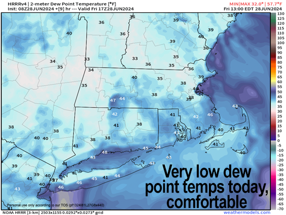
We have an absolutely gorgeous day ahead with highs in the mid to upper 70s as dew point temps crash into the 30s(!) which means VERY low humidity and heightened atmospheric comfort.
You couldn’t have a more meteorologically stable day to look forward to!
Lows tonight dip into the mid to upper 50s as high clouds start to build into the region.
For Saturday, we should see partly sunny skies earlier in the morning, but it will be a mostly cloudy day, and an increasingly humid one at that.
Highs will sit in the 75-80º range, and a warm front will work into the region in the evening with scattered showers and perhaps a thunderstorm moving in by Saturday night.
The warm frontal passage will hold temps in the mid to upper 60s for lows and it will become very humid with patchy fog possible at night, along with additional periods of showers.
For Sunday, which is NOT my weekend pick, humidity will be pinned with dewpoints in the low 70s at least, and the potential for morning thunderstorms.
Depending on how things setup for Sunday, we could see that first wave of showers and storms move through overnight Saturday and into early Sunday morning, and then develop a break with some clearing into the mid day.
A cold front will be working east out of New York state and approaching the Berkshires by the middle of Sunday afternoon.
If we get this sunny break, high temps could spike into the mid 80s to low 90s, and if this happens, the combination of a heated moisture-rich surface along with the forcing from our incoming cold front and associated strong wind shear could produce a squall line of strong to severe thunderstorms sweeping the region between say 1-5pm from west to east, with damaging winds possible, street flooding, and even some hail.
The cold front will sweep our newly-surged humidity and shower/storm activity seaward, with lows dipping into the 55-60º range as skies clear late.
Monday through Wednesday looks like a fair weather stretch behind this front and severe weather threat, with plenty of sunshine and lowered humidity (at least for Monday and Tuesday).
Highs will be in the 70s on Monday with lows in the 50s, and then highs should rise into the 80s for Tuesday and Wednesday with lows near 60º.
In addition, humidity may start to rise as the high pressure that brings our loveliness for Monday and Tuesday will position itself south of us, ahead of another cold front that should bring some more showers to the region by late Wednesday night or Thursday.
Have a great day!
>>> BE KIND <<<
“Hello babies. Welcome to Earth. It’s hot in the summer and cold in the winter. It’s round and wet and crowded. On the outside, babies, you’ve got a hundred years here. There’s only one rule that I know of, babies: Goddamn it, you’ve got to be kind.”
–Kurt Vonnegut