
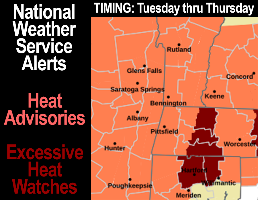
[7:03AM MON 6/17/24] EXCESSIVE HEAT WATCHES HAVE BEEN HOISTED FOR THE ENTIRE CT RIVER VALLEY IN WMASS AND NORTH-CENTRAL CT… HEAT ADVISORIES HAVE BEEN HOISTED FOR THE REST OF THE GREATER WMASS REGION, AND MUCH OF NEW ENGLAND FOR THAT MATTER… TONS OF SUNSHINE THIS WEEK… VERY WARM TODAY, THEN HOT AND HUMID THE REST OF THE WEEK WITH HEAT INDICES (TEMP+DEWPOINT COMBO) PUSHING 105º AT TIMES… ISOLATED SHOWER OR STORM POSSIBLE, BUT LIKELY DRY UNTIL FRIDAY… FRIIDAY THROUGH SUNDAY BETTER CHANCE SCATTERED SHOWERS AND T-STORMS, STILL HOT AND HUMID BUT NOT AS MUCH AS PEAK HEAT DURING WEDNESDAY THROUGH FRIDAY…
~~~~~~~~~~~~~~~~~~~~~~
TABLE OF CONTENTS
* Daily Celestials (Sun/Moon Data)
* Sponsor Note
* Weekly Weather Nutshell
* Join My Newsletter (Free 70 page ebook)
* Morning Discussion
* TIP: Scroll below for sections, or read all
~~~~~~~~~~~~~~~~~~~~~~
YOUR DAILY CELESTIALS
~~~~~~~~~~~~~~~~~~~~~~
STAR:
–OUR STAR ROSE AT: 5:14am this morning
–OUR STAR SETS AT: 8:28pm this evening
–TOTAL DAYLIGHT TIME: 15 hours and 14 minutes
MOON:
–OUR MOON RISES AT: 4:19pm this morning
–MOON RISE DIRECTION: East-Southeast
–OUR MOON SETS AT: 2:29am tomorrow morning
–MOON SET DIRECTION: West-Southwest
–MOON PHASE: Waxing Gibbous (79.0%)
~~~~~~~~~~~~~~~~~~~~~~
A NOTE FROM OUR SPONSOR
~~~~~~~~~~~~~~~~~~~~~~
Dave Hayes The Weather Nut is Sponsored by Individual Community Members, Patrons, and Tandem Bagel Company… No matter the weather, Tandem Bagel is always there for you at several valley locations to make your mornings brighter! With *New Pizza Bagels(!)*, along with bagels baked fresh daily (including Gluten-Free options), house-whipped cream cheese, coffee, and tons of lunch options, Tandem is the perfect quick stop for lunch, breakfast, or a coffee and bagel to go.
You can either A) visit them in Easthampton, Northampton, Hadley, Florence, and/or West Springfield, B) hire them to cater your next event, or C) use their super-streamlined online ordering tool by visiting their website and clicking the “Catering” or “Order Online” links.
~~~~~~~~~~~~~~~~~~~~~~
WEEKLY WEATHER NUTSHELL
~~~~~~~~~~~~~~~~~~~~~~
–Heat Advisories and Excessive Heat Watches have been activated by the NWS
–Lows in the low 50s this morning will be the last comfy morning temps for a while, enjoy it
–High pressure dominates today and the rest of this week
–Mostly sunny skies, highs mid to upper 80s, humidity starts to rise
–Mostly clear tonight with lows in the low 60s
–Tuesday is hot and humid, highs low to mid 90s
–Wednesday is hot and humid, highs mid to upper 90s
–Thursday is peak heat and humidity, highs mid 90s to low 100s
–Friday is hot and humid with highs in the upper 80s to mid 90s, more clouds around late in the day
–Lows 65-70º Tuesday night through Friday night
–Scattered showers with a few thunderstorms possible Friday through Sunday, but a washout is not expected
–Highs mid 80s to low 90s over the coming weekend, continued humid
~~~~~~~~~~~~~~~~~~~~~~
GET DAVE’S TOP 12 MOST POTENT STORMS
IN WMASS HISTORY (Plus 3 honorable mentions)
Grab my detailed (and free) 70-page local storm book filled with storm histories, personal stories, and impacts/facts when you sign up for my free weekly newsletter called “The Nutletter” by clicking the this link to my secure website.
~~~~~~~~~~~~~~~~~~~~~~
YOUR MORNING DISCUSSION
~~~~~~~~~~~~~~~~~~~~~~
Good morning folks, now THAT was a lovely weekend, right? Give me a show of hands if that was one of the better summer weather weekends you’ve lived through.
As for our weather going forward this week, I have two words for you:
Soup’s on!
For Tuesday through Friday, hot temperatures (highs in the 90s) and high humidity (dewpoints in the upper 60s to mid 70s) will combine to produce heat indices / apparent temperatures / feels-like temps (all the same thing, fyi) in the upper 90s to mid 100s which has prompted Heat Advisories to be hoisted through much of New England, and Excessive Heat Watches right here in our Pioneer Valley from Greenfield down through Northampton, Springfield and Hartford CT.
The peaceful, lovely, and northwest-flowing high pressure system that delivered our amazing weekend is now southeast of us, and will continue to drop south, and become a Bermuda high that will run strong, hot and humid southwesterly flow into New England, combining with a potent upper level ridge over the eastern U.S.
This will set the stage for the potential to experience record-breaking temps (both high maxes, and high mins), and will make for a very uncomfortable and (for some) dangerous combination of weather elements that can cause heat illnesses (heat stroke, heat exhaustion) and also cause problems for those who are infirm, have respiratory issues, and for outdoor workers who fail to hydrate properly and seek cooling or shade at times.
The core of the heat and humidity will move through Wednesday through Friday, but begin tomorrow after a very warm day today with highs in the 80s.
Get the air conditioners in today if you haven’t, is my advice.
Some of us could see highs in the low 90s even through this coming\ weekend, which could produce a whopper of a first heat wave, stretching 6 days for some!
It does look like by Friday into the weekend this massive upper ridge will start to orient itself more west to east rather than southwest to northeast, which will allow cooler temps aloft to work in along with a potential shortwave to pass neaer enough too allow both elements to destabilize the atmosphere to produce more scattered showers and thunderstorms.
But without a cold front to force the air skyward, we’ll rely more on differential heating and presence of our mountains to the west (hot below, cooler at the tops) to get air moving up to produce some showers/storms at times.
Highs over the weekend look to run in the 85-90º range, so this record heat won’t last, but I am telling you, this is gonna be a tough weather week for those who don’t do well with heat and humidity.
For those who thrive in such weather, this is your week.
Have a great day, and I will post again this evening.
>>> BE KIND <<<
“Hello babies. Welcome to Earth. It’s hot in the summer and cold in the winter. It’s round and wet and crowded. On the outside, babies, you’ve got a hundred years here. There’s only one rule that I know of, babies: Goddamn it, you’ve got to be kind.”
–Kurt Vonnegut