~~~~~~~~~~~~~~~~~~~~~~
TABLE OF CONTENTS
* Daily Celestials (Sun/Moon Data)
* Weekly Nutletter Giveaway
* Morning Discussion
* TIP: Scroll below for sections, or read all
~~~~~~~~~~~~~~~~~~~~~~
YOUR DAILY CELESTIALS
~~~~~~~~~~~~~~~~~~~~~~
STAR:
–OUR STAR ROSE AT: 5:13am this morning
–OUR STAR SETS AT: 8:27pm this evening
–TOTAL DAYLIGHT TIME: 15 hours and 14 minutes
MOON:
–OUR MOON RISES AT: 12:11pm this morning
–MOON RISE DIRECTION: East
–OUR MOON SETS AT: 1:11am tomorrow morning
–MOON SET DIRECTION: West
–MOON PHASE: Waxing Crescent (42.8%)
~~~~~~~~~~~~~~~~~~~~~~
A NOTE FROM OUR SPONSOR
~~~~~~~~~~~~~~~~~~~~~~
Dave Hayes The Weather Nut is Sponsored by Individual Community Members, Patrons, and Tandem Bagel Company… No matter the weather, Tandem Bagel is always there for you at several valley locations to make your mornings brighter! With *New Pizza Bagels(!)*, along with bagels baked fresh daily (including Gluten-Free options), house-whipped cream cheese, coffee, and tons of lunch options, Tandem is the perfect quick stop for lunch, breakfast, or a coffee and bagel to go.
You can either A) visit them in Easthampton, Northampton, Hadley, Florence, and/or West Springfield, B) hire them to cater your next event, or C) use their super-streamlined online ordering tool by visiting their website and clicking the “Catering” or “Order Online” links.
~~~~~~~~~~~~~~~~~~~~~~
GET DAVE’S TOP 12 MOST POTENT STORMS
IN WMASS HISTORY (Plus 3 honorable mentions)
Grab my detailed (and free) 70-page local storm book filled with storm histories, personal stories, and impacts/facts when you sign up for my free weekly newsletter called “The Nutletter” by clicking this link to my secure website.
~~~~~~~~~~~~~~~~~~~~~~
YOUR MORNING DISCUSSION
~~~~~~~~~~~~~~~~~~~~~~
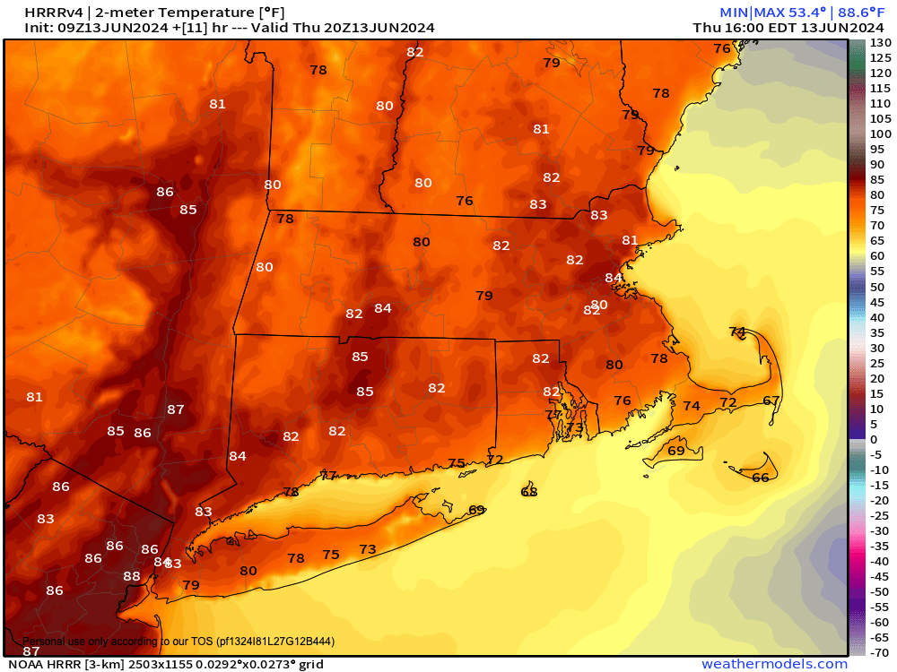
Good morning folks, we have a lovely day ahead, and one that will be significantly warmer with highs well into the 80s as humidity starts to creep up.
Still, mostly sunny skies will make this a glorious early summer day.
By later afternoon, southerly gusts will be kicking up over 20mph at times, and this should last into tonight as more moist air advects into the region, drawn north and northeast into New England ahead of tomorrow’s cold frontal passage.
Give this, lows will only dip into the low to mid 60s as humidity continues to creep up, with some isolated patchy fog possible late.
For Friday, uncertainty remains as to how much cloud debris will precede the approach and passage of the main line and cluster of showers, downpours, and strong to potentially severe thunderstorms, which occurs between 2-8pm.
Prior to that, we could see some scattered showers as early as mid to late morning, and we can’t rule out thunder then, either.
Overall, expect a partly sunny morning, followed by a more-clouds-than-sun afternoon in terms of skies.
In terms of severe weather, if enough clouds develop in the morning and temps are kept down into the upper 70s to low 80s, we could knock down the potential for damaging straight line wind gusts, which would then make this more of a “street flooding with low chance for isolated flash flooding” event.
Still, we remain in a Level 2 out of 5 severe thunderstorm risk from the SPC, as one or two storms could knock down some trees or power lines in sporadic fashion, so the threat is there for strong wind.
Everything clears out of here by midnight or so, with lows dipping into the mid to upper 50s.
This will pave the way for an amazing weekend!
High pressure builds in from the northwest and will produce mostly sunny skies all weekend with mostlty clear nights. Highs will be in the 70s to near 80º both days, and lows in the 40s Saturday night and 50s Sunday night with lower humidity, so get out and enjoy it, because the heat and humidity is on the way!
Monday will be our transition day, and pretty similar to today actually, with highs in the 80s under mostly sunny skies with increasing humidity.
Once we get to Tuesday through Friday, the heat will be upon us, as that high pressure northwest of us this weekend will position itself south-southeast of us next week. Given clockwise circulation around northern hemispheric high pressure systems, it will be pumping heat and humidity into our region on strong southwest flow.
Tuesday is looking borderline hot with highs in the mid 80s to low 90s, but Wednesday through Friday looks like we’ll see highs in the upper 80s to mid 90s with a chance at some folks hitting 100º on Thursday with dewpoints cresting 70º!
I expect the NWS will be hoisting Heat Advisories if this trend continues and I would not be surprised to see Excessive Heat Warnings by mid to late week.
Lots of impactful weather changes are on the way to keep checking back and I’ll keep you updated on our severe weather potential and increasingly likely first heat wave of 2024!
Have a great day!
>>> BE KIND <<<
“Hello babies. Welcome to Earth. It’s hot in the summer and cold in the winter. It’s round and wet and crowded. On the outside, babies, you’ve got a hundred years here. There’s only one rule that I know of, babies: Goddamn it, you’ve got to be kind.”
–Kurt Vonnegut
