~~~~~~~~~~~~~~~~~~~~~~
TABLE OF CONTENTS
* Daily Celestials (Sun/Moon Data)
* Weekly Nutletter Giveaway
* Morning Discussion
* TIP: Scroll below for sections, or read all
~~~~~~~~~~~~~~~~~~~~~~
YOUR DAILY CELESTIALS
~~~~~~~~~~~~~~~~~~~~~~
STAR:
–OUR STAR ROSE AT: 5:13am this morning
–OUR STAR SETS AT: 8:27pm this evening
–TOTAL DAYLIGHT TIME: 15 hours and 14 minutes
MOON:
–OUR MOON RISES AT: 11:09am this morning
–MOON RISE DIRECTION: East-Northeast
–OUR MOON SETS AT: 12:53am tomorrow morning
–MOON SET DIRECTION: West-Northwest
–MOON PHASE: Waxing Crescent (33.5%)
~~~~~~~~~~~~~~~~~~~~~~
A NOTE FROM OUR SPONSOR
~~~~~~~~~~~~~~~~~~~~~~
Dave Hayes The Weather Nut is Sponsored by Individual Community Members, Patrons, and Tandem Bagel Company… No matter the weather, Tandem Bagel is always there for you at several valley locations to make your mornings brighter! With *New Pizza Bagels(!)*, along with bagels baked fresh daily (including Gluten-Free options), house-whipped cream cheese, coffee, and tons of lunch options, Tandem is the perfect quick stop for lunch, breakfast, or a coffee and bagel to go.
You can either A) visit them in Easthampton, Northampton, Hadley, Florence, and/or West Springfield, B) hire them to cater your next event, or C) use their super-streamlined online ordering tool by visiting their website and clicking the “Catering” or “Order Online” links.
~~~~~~~~~~~~~~~~~~~~~~
GET DAVE’S TOP 12 MOST POTENT STORMS
IN WMASS HISTORY (Plus 3 honorable mentions)
Grab my detailed (and free) 70-page local storm book filled with storm histories, personal stories, and impacts/facts when you sign up for my free weekly newsletter called “The Nutletter” by clicking this link to my secure website.
~~~~~~~~~~~~~~~~~~~~~~
YOUR MORNING DISCUSSION
~~~~~~~~~~~~~~~~~~~~~~
Good morning folks, truth be told we’ve got lots of sunshine coming up over the next week or so, with very little rain chances on the table.
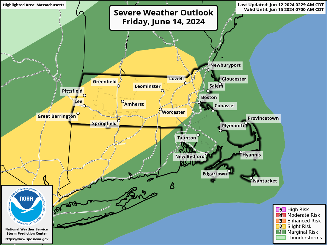
However, the biggest rain chance we do have could bring with it a growing chance for strong to severe thunderstorms on Friday afternoon with the primary threats being isolated damaging wind gusts and street flooding, with a secondary chance for hail.
Before all of that transpires, we have a pair of mostly nice days ahead with lower humidity today, and increasing humidity tomorrow into Friday.
As our upper low finally weakens and lifts east of our region, we’ll have one more day with partial sunshine and a few isolated showers possible like we had yesterday.
Highs will climb into the mid to upper 70s, with lows in the low to mid 50s under partly cloudy skies.
For Thursday, our upper low is gone, and high pressure will be flexing south of us, sending southwest flow into the region, and bumping our temps up into the mid to upper 80s for highs under mostly sunny skies.
Lows will only hang in the low to mid 60s, and as humidity increases, we can’t rule out some patchy fog late at night.
FRIDAY THUNDERSTORM POTENTIAL
Friday is our shower and thunderstorm day during the afternoon, but in terms of maximizing severe potential in terms of strong gusty winds, we’re going to be relying on instability to optimize.
We’ll have a frontal boundary which initiates rising air motion, we’ll have plentyt of moisture and humidity in place (though not extreme amounts), and we’ll have wind shear moving into the region, but it’s the temps maximizing ahead of the squall line that will be determined by any preceding “cloud debris”, so that’s what I will be monitoring.
You also need the shear, the arrival of the front, and the moisture and instability to coincide, and sometimes if those parameter maxes are misaligned, it can tamp down the severe threat.
The bottom line is that the Storm Prediction Center has posted a Level 2 out of 5 Severe Thunderstorm threat potential, and given the signal for strong low level lapse rates, it is localized strong and potentially damaging wind gusts along with street flooding that could be the main issues, with hail possible as well.
The timeframe would be roughly 2-8pm from northwest to southeast, and highs should reach the low to mid 80s at least, with lows in the mid 50s with clearing after midnight.
This coming weekend looks absolutely perfect and supportive of all outdoor plans as high pressure builds in from the northwest, and sits on us like a mother hen for Sunday.
Highs will be well into the 70s both days with lows either side of 50º with very comfortable humidity levels, and tons of sun each day.
By Monday, we see that high slip southeast, setting up a true Bermuda High pressure system by mid week.
This is likely going to pump humid southwest flow into New England with tons of sunshine expected next week, but also with tons of heat and humidity.
Summer’s coming, folks, so it’s time to gear up.
Highs on Monday crest well into the 80s with lows in the low 60s as humidity starts to increase.
However, by Tuesday through Thursday, heat and humidity will maximize with highs likely in the upper 80s to mid/upper 90s during this period with dewpoints cresting 70º, along with lows in the mid 60s to low 70s at night.
How this heat dome ends by late next week or the following weekend, I am unsure, but I do know that Triple H weather is coming, and we’ll all be either rejoicing with glee or crying (or shedding perspiration?) in our basements.
I will be doing the latter, but will ensure I have a plethora of towels around me to keep my computer from shorting out so I can keep showing up here.
Have a great day!
>>> BE KIND <<<
“Hello babies. Welcome to Earth. It’s hot in the summer and cold in the winter. It’s round and wet and crowded. On the outside, babies, you’ve got a hundred years here. There’s only one rule that I know of, babies: Goddamn it, you’ve got to be kind.”
–Kurt Vonnegut
