~~~~~~~~~~~~~~~~~~~~~~
TABLE OF CONTENTS
* Daily Celestials (Sun/Moon Data)
* Weekly Weather Nutshell
* Morning Discussion
* TIP: Scroll below for sections, or read all
~~~~~~~~~~~~~~~~~~~~~~
YOUR DAILY CELESTIALS
~~~~~~~~~~~~~~~~~~~~~~
STAR:
–OUR STAR ROSE AT: 5:14am this morning
–OUR STAR SETS AT: 8:26pm this evening
–TOTAL DAYLIGHT TIME: 15 hours and 12 minutes
MOON:
–OUR MOON RISES AT: 8:58am this morning
–MOON RISE DIRECTION: East-Northeast
–OUR MOON SETS AT: 12:08am tomorrow morning
–MOON SET DIRECTION: West-Northwest
–MOON PHASE: Waxing Crescent (16.8%)
~~~~~~~~~~~~~~~~~~~~~~
A NOTE FROM OUR SPONSOR
~~~~~~~~~~~~~~~~~~~~~~
Dave Hayes The Weather Nut is Sponsored by Individual Community Members, Patrons, and Tandem Bagel Company… No matter the weather, Tandem Bagel is always there for you at several valley locations to make your mornings brighter! With *New Pizza Bagels(!)*, along with bagels baked fresh daily (including Gluten-Free options), house-whipped cream cheese, coffee, and tons of lunch options, Tandem is the perfect quick stop for lunch, breakfast, or a coffee and bagel to go.
You can either A) visit them in Easthampton, Northampton, Hadley, Florence, and/or West Springfield, B) hire them to cater your next event, or C) use their super-streamlined online ordering tool by visiting their website and clicking the “Catering” or “Order Online” links.
~~~~~~~~~~~~~~~~~~~~~~
YOUR WEEKLY WEATHER NUTSHELL
~~~~~~~~~~~~~~~~~~~~~~
–Isolated shower chance today, tomorrow and Wednesday afternoon, but most of us should remain dry
–Partly to mostly sunny skies today and tomorrow, mostly sunny Wednesday
–Highs upper 60s to mid 70s today, light west to southwest wind
–Lows upper 40s to low 50s, coolest night we’ll see for a while, partly cloudy
–Highs low to mid 70s tomorrow
–Lows low to mid 50s, more clouds than clear
–Highs upper 70s to low 80s Wednesday with lows in the mid 50s
–Thursday is mostly sunny, warmer and more humid, highs mid to upper 80s, lows low to mid 60s
–Friday is hot and humid, highs either side of 90º, mostly sunny early, clouds build by mid to late afternoon
–Cold front moves in, with scattered strong to severe thunderstorms possible, clearing late
–Lovely looking weekend with highs either side of 80º, and lows in the upper 50s, less humid
–Looking hot and humid early next week, with Monday as transition day, and Tuesday and Wednesday possibly reaching well into the 90s for highs, with high humidity
~~~~~~~~~~~~~~~~~~~~~~
YOUR MORNING DISCUSSION
~~~~~~~~~~~~~~~~~~~~~~
Good morning folks, we’re in the waning stages of our upper low’s influence through the middle of this week, after which #SummahStandsUp.
The next 3 days looks quite nice, actually, with lower humidity, partly to mostly sunny skies, and only a chance each afternoon for a few isolated showers with most of us staying dry.
Highs will reach the upper 60s to mid 70s today, low to mid 70s tomorrow, and the upper 70s to low 80s on Wednesday, with lows in the upper 40s to low 50s tonight, and low to mid 50s Tuesday and Wednesday night.
It looks like we should see partly cloudy skies tonight with mostly clear periods, and then more clouds Tuesday night, with less clouds Wednesday night.
This upcoming temperate and comfortable stretch through mid-week is due to an upper low centered over New Brunswick, Canada and Aroostook County, Maine (a/k/a “The County”). This low will finally lift northeast and out of here by late week, while high pressure builds south of us, and an upper level ridge moves into the eastern seaboard.
This will create southwest flow, and allow temps to soar into the mid to upper 80s on Thursday under mostly sunny skies with lows in the low to mid 60s. Humidity will be rising as well during this time.
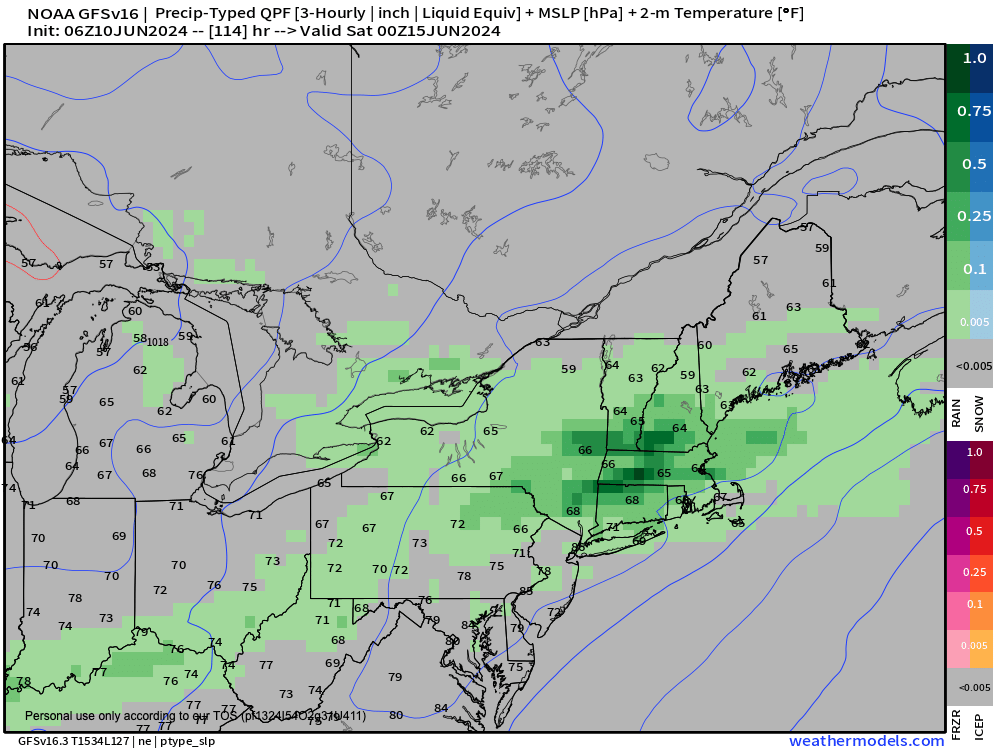
By Friday, humidity will push dewpoints well into the 60s with highs in the upper 80s to low 90s as a cold front tracks east through New York state and heading for the greater WMass region.
This has the potential for produce strong to severe thunderstorms in via a QCLS (Quasi-Convective Linear System), a/k/a “squall line” later Friday afternoon, with pretty strong wind shear, ample instability, plenty of moisture and a lifting mechanism, that being the cold front.
Those are the primary 4 parameters to consider, so I will be monitoring this during the week. If the frontal passage is delayed, that could tamp down the threat, so stay tuned for updates.
Behind the front it looks like a lovely Father’s Day Weekend is in store with highs either side of 80º, mostly sunny skies, and less humidity.
By early to mid week, we could get our first real hit of deeper summer conditions with much higher humidity that could affect air quality, and a chance to soar well into the 90s, so stay tuned for updates for that Tuesday/Wednesday period.
Have a great day!
>>> BE KIND <<<
“Hello babies. Welcome to Earth. It’s hot in the summer and cold in the winter. It’s round and wet and crowded. On the outside, babies, you’ve got a hundred years here. There’s only one rule that I know of, babies: Goddamn it, you’ve got to be kind.”
–Kurt Vonnegut
