
TABLE OF CONTENTS
* Daily Celestials (Sun/Moon Data)
* Sponsor Note
* Join My Newsletter (& get my Top12WMassStorms ebook!)
* Morning Discussion
* TIP: Scroll below for sections, or read all
~~~~~~~~~~~~~~~~~~~~~~
YOUR DAILY CELESTIALS
~~~~~~~~~~~~~~~~~~~~~~
STAR:
–OUR STAR ROSE AT: 5:22am this morning
–OUR STAR SETS AT: 8:27pm this evening
–TOTAL DAYLIGHT TIME: 15 hours and 5 minutes
MOON:
–OUR MOON SETS AT: 10:34pm tonight
–MOON SET DIRECTION: West-Northwest
–OUR MOON RISES AT: 8:55am tomorrow morning
–MOON RISE DIRECTION: East-Northeast
–MOON PHASE: Waxing Crescent (6.5%)
~~~~~~~~~~~~~~~~~~~~~~
A NOTE FROM OUR SPONSOR
~~~~~~~~~~~~~~~~~~~~~~
Dave Hayes The Weather Nut is Sponsored by Individual Community Members, Patrons, and Tandem Bagel Company… No matter the weather, Tandem Bagel is always there for you at several valley locations to make your mornings brighter! With *New Pizza Bagels(!)*, along with bagels baked fresh daily (including Gluten-Free options), house-whipped cream cheese, coffee, and tons of lunch options, Tandem is the perfect quick stop for lunch, breakfast, or a coffee and bagel to go.
You can either A) visit them in Easthampton, Northampton, Hadley, Florence, and/or West Springfield, B) hire them to cater your next event, or C) use their super-streamlined online ordering tool by visiting their website and clicking the “Catering” or “Order Online” links.
~~~~~~~~~~~~~~~~~~~~~~
DAVE’S WEEKLY NEWSLETTER
~~~~~~~~~~~~~~~~~~~~~~
Get my Top 12 Most Powerful WMass Storms in History, Plus 3 honorable mentions in a detailed, and free, 70-page local storm book at this link to my secure website.
~~~~~~~~~~~~~~~~~~~~~~
DAVE’S MOBILE APP (SET FOR RELEASE BY 2025)
~~~~~~~~~~~~~~~~~~~~~~
It’s been years in the thinking and now it’s getting made so I can more reliably show up for you… get on the list at this link.
~~~~~~~~~~~~~~~~~~~~~~
YOUR MORNING DISCUSSION
~~~~~~~~~~~~~~~~~~~~~~
Good morning everybody, we’ve got one more mostly sunny day ahead before our weather becomes more unsettled for the foreseeable future, best I can tell as of this writing.
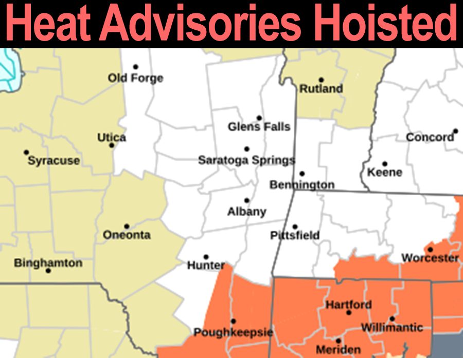
With our sunshine will come some heat and humidity, and it will be hot enough that Heat Advisories have been hoisted for Hampden and southern Worcester Counties down into northern CT, and I wouldn’t be surprised if we don’t see a repeat for some of those areas Tuesday as well.
Highs today will reach the mid 80s to low 90s with some mid 90s possible in the Springfield to Hartford corridor. Dewpoints will be in the 60s, so while it will be humid for sure, it won’t be as bad as it has been (or that it’s going to be by tomorrow through the week).
Lows tonight will dip into the upper 60s to low 70s as humidity starts to creep up, and as such, patchy fog will again be possible as some of us have seen this morning.
Once we get to Tuesday/tomorrow, we’ll see more of a partly sunny day as a frontal boundary lifts into our region as a warm front.
This will both cause humidity to continue to slowly climb, as well as help to focus some scattered showers and thunderstorms by later afternoon and early evening in the greater WMass region.
Highs will again reach the mid 80s to low 90s, and lows will dip into the upper 60s to low 70s with similar dewpoints, meaning more patchy fog is expected.
By the Wednesday to Thursday timeframe, we’re turning our attention to the rainy remnants of no-longer-a-Hurricane Beryl.
After drenching Texas, this system is going to lift north and then northeast by Thursday morning, and will likely interact with our nearby frontal boundary in southern and south-central New England.
Highs will be in the low to mid 80s Wednesday and Thursday, with lows near 70º, and it will be very humid.
Periods of showers, downpours and thunderstorms are expected, and some storms could be strong Wednesday into Thursday as tropical moisture and remnant wind shear (i.e. changes in wind speed and/or direction from surface to sky) will be pushed into the greater WMass region as Beryl passes to our northwest.
Exactly where Beryl tracks will be important, because the current trend has been more southerly toward our region, and as of now, the northern Berkshires, Franklin County and especially southern VT into southwest NH could see the heaviest rain, with flash flood potential.
Lastly, an upper trough to our west which will guide Beryl through New York state and northern VT will be pressing against the northwest flank of our big Bermuda high in the western Atlantic Ocean.
The potential exists for even more rain to be extended into the Friday to Saturday timeframe with highs in the 80s and high humidity.
We need to get closer to that timeframe for me to better parse things out, but just know we could have extended period or periods of wet weather with high humidity before we can get any relief with the passage of a cold front as Beryl’s remnants fully pull away, well to the east of New England.
I don’t see this happening until at least Sunday or Monday at the moment, so enjoy today and tomorrow morning’s sunshine as we’ll be likely to see more clouds and unsettled conditions by Tuesday afternoon into the coming weekend.
Have a great day!
>>> BE KIND <<<
“Hello babies. Welcome to Earth. It’s hot in the summer and cold in the winter. It’s round and wet and crowded. On the outside, babies, you’ve got a hundred years here. There’s only one rule that I know of, babies: Goddamn it, you’ve got to be kind.”
–Kurt Vonnegut