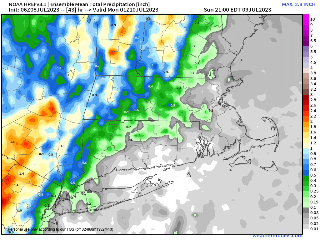
Most rainy west of the I-91 in high terrain
>>> MORNING DISCUSSION <<< Good morning everybody, we've got one more day to move through before deeper moisture at all levels (and not just at the surface in the form of humidity and resultant instability) tracks back into the region for the end of the weekend into the start of next week. For today, it will be very warm under partly sunny skies with highs in the mid to upper 80s. It is already quite humid with dewpoints into the low to mid 70s in some cases!! With weak wind shear overhead today, we will once again be in pulse-storm mode where scattered showers and thunderstorms fire up in the early to mid afternoon over the high terrain due to differential heating (moist air gets double "benefit" of being forced to rise by presence of mountain, up a temperature gradient that is cooler aloft, so it focuses and induces shower/storm formation). The "pulse" part is that without wind shear, the storms can't get very organized and tend to ingest their own rain-cooled air into updrafts and weaken themselves, so they flare up and down, you can see it happen on radar if you pay attention. #RadarIsFun #DaveIsANerd #ThisIsNotNews There is a low chance for microburst given drier air aloft, but it would be an isolated instance, and is unlikely to occur. The main issue is torrential rain from any showers or storms this afternoon, which should weaken by evening as the surface cools. Lows tonight will drop into the mid to upper 60s as deeper moisture takes aim at the WMass region for the weekend's end. Patchy fog is possible. On Sunday, more clouds will be present, especially as the day wears on, and highs will reach the upper 70s to mid 80s with less sunshine. It will still be quite humid, and a mid-level system near the Great Lakes will be tracking east, and sending moisture into the region at all levels. This will occur while a weak surface low develops off of the northern Mid-Atlantic and lifts northeast into southern New England Sunday night into Monday. The first half of the day should be mostly dry, but once we get into the mid afternoon and onward, showers, downpours and thunderstorms will develop in scattered coverage. By Sunday night into Monday, areal coverage of showers, downpours and a few embedded thunderstorms will increase, and some areas (especially west of I-91 in the high terrain of northwest CT, WMass and SVT) should see heavy rainfall, capable of producing isolated areas of flash flooding. Lows Sunday night will be in the mid 60s, and highs on Monday will only reach the mid to upper 70s with rainy conditions. By Monday afternoon we may see a lessening of activity as that shifts north and east, but a few showers will still be possible at night with lows in the low to mid 60s. Tuesday and Wednesday should feature a period of upper level ridging moving into the region with a bit lower humidity and more sunshine with highs in the mid 80s by Tuesday and either side of 90º on Wednesday, which is DEFINITELY looking like the pick of the upcoming week! Humidity surges back in on Thursday and into Friday with increased shower and thunderstorm chances with highs in the 80s. While many are sick of this pattern, the bright side is that at least there is only low chances for any severe weather such as damaging gusty winds or larger hail, and there is so severe heat expected, or upcoming heat waves that I can see. But for the next 7-10 days, it's alternating periods of high humidity with showers, downpours and thunderstorms scattered about, mixed with a couple of drier/sunnier days before we do it all over again. Have a great day! >>> BE KIND <<< “Hello babies. Welcome to Earth. It's hot in the summer and cold in the winter. It's round and wet and crowded. On the outside, babies, you've got a hundred years here. There's only one rule that I know of, babies: Goddamn it, you've got to be kind.” --Kurt Vonnegut
