Good morning everybody, quick report today given the holiday, and I hope whatever you’re doing it’s enjoyable and/or peaceful.
We have areas of showers running east-notheast through the region this morning with some folks picking up 1-2″ of rain just overnight (others got much less).
Adding that on top of rain already received, and additional rains expected today, flash flooding in localized areas is a concern, and Flood Watches continue across the valley, north-central / northeast CT, and CMass for that reason.
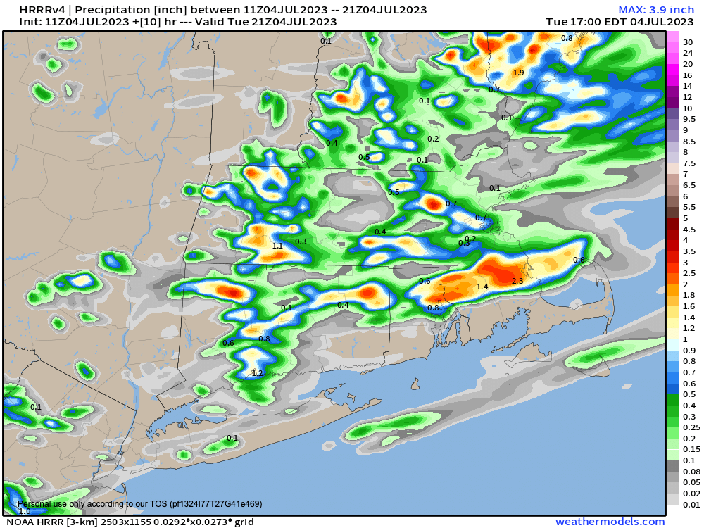
You can see in the attached chart that some may get lowered amounts of rain, but the various locales that do get the heaviest showers over them today, is where localized flash flooding could occur, especially if that is around central and eastern Hampden County down into northern CT where heavy rain fell overnight.
It is very humid out, and some patchy fog will burn off, but as temps rise as the Sun does this morning, instability will increase.
This should combine with an incoming upper level feature that will interact with increasing instability focused around a frontal boundary that will be sagging south today through our region.
This should serve as a focus to help redevelop showers, downpours and thunderstorms which will be tracking more or less east, while the whole line will be sagging south and southeast towards the southern coast by tonight.
This puts the greater WMass region in a general 10am-4pm window where heavier rains will develop and sag south and southeast through the region, and it could rain HARD at times given how warm it is way up from the surface into the mid-levels.
Thunderstorms should be mixed in, but only a few strong ones would be more likely to develop, but I will keep an eye on it.
Highs today will reach the upper 70s to low 80s under mostly cloudy skies with some sunny breaks possible mostly before and after this expected cluster of shower activity redevelops.
It will be very humid today, tonight and through the week into the weekend, with no lowered humidity in sight at the moment.
By Wednesday through Friday, we’ll see some upper level ridging move into the region, which will produce sunnier skies and hotter temps with highs in the mid 80s to low 90s and heat indices into the mid 90s.
An isolated shower or storm can’t be ruled out, but those would likely be in the high terrain areas, if at all. Lows will be in the 60s to low 70s.
By next weekend, a frontal boundary will be slowly approaching our region, and create conditions for afternoon showers and thunderstorms to develop, with a possible wave of low pressure moving through by Monday with heavier rainfall.
We’re in this rinse and repeat pattern, folks, but at least we’ve got a few sunny, summer days coming up, you’ll just need to find a way cool down.
Have a great day, whatever you are up to today!
