
TABLE OF CONTENTS
* Daily Celestials (Sun/Moon Data)
* Sponsor Note
* Join My Newsletter
(& get my Top12WMassStorms ebook!)
* Morning Discussion
* TIP: Scroll below for sections, or read all
~~~~~~~~~~~~~~~~~~~~~~
YOUR DAILY CELESTIALS
~~~~~~~~~~~~~~~~~~~~~~
STAR:
–OUR STAR ROSE AT: 5:43am this morning
–OUR STAR WILL SET AT: 8:09pm this evening
–TOTAL DAYLIGHT TIME: 14 hours and 26 minutes
MOON:
–OUR MOON WILL SET AT: 5:52pm this afternoon
–MOON SET DIRECTION: Northwest
–OUR MOON WILL RISE AT: 2:19am tomorrow morning
–MOON RISE DIRECTION: Northeast
–MOON PHASE: Waning Crescent (16.6%)
~~~~~~~~~~~~~~~~~~~~~~
A NOTE FROM OUR SPONSOR
~~~~~~~~~~~~~~~~~~~~~~
Dave Hayes The Weather Nut is Sponsored by Individual Community Members, Patrons, and Tandem Bagel Company… No matter the weather, Tandem Bagel is always there for you at several valley locations to make your mornings brighter! With *New Pizza Bagels(!)*, along with bagels baked fresh daily (including Gluten-Free options), house-whipped cream cheese, coffee, and tons of lunch options, Tandem is the perfect quick stop for lunch, breakfast, or a coffee and bagel to go.
You can either 1) visit them in Easthampton, Northampton, Hadley, Florence, and/or West Springfield, 2) hire them to cater your next event, or 3) use their super-streamlined online ordering tool by visiting their website and clicking the “Catering” or “Order Online” links.
~~~~~~~~~~~~~~~~~~~~~~
DAVE’S WEEKLY NEWSLETTER (Top 12 WMass Storms)
DAVE’S MOBILE APP (Late 2024 Release)
~~~~~~~~~~~~~~~~~~~~~~
YOUR MORNING DISCUSSION
~~~~~~~~~~~~~~~~~~~~~~
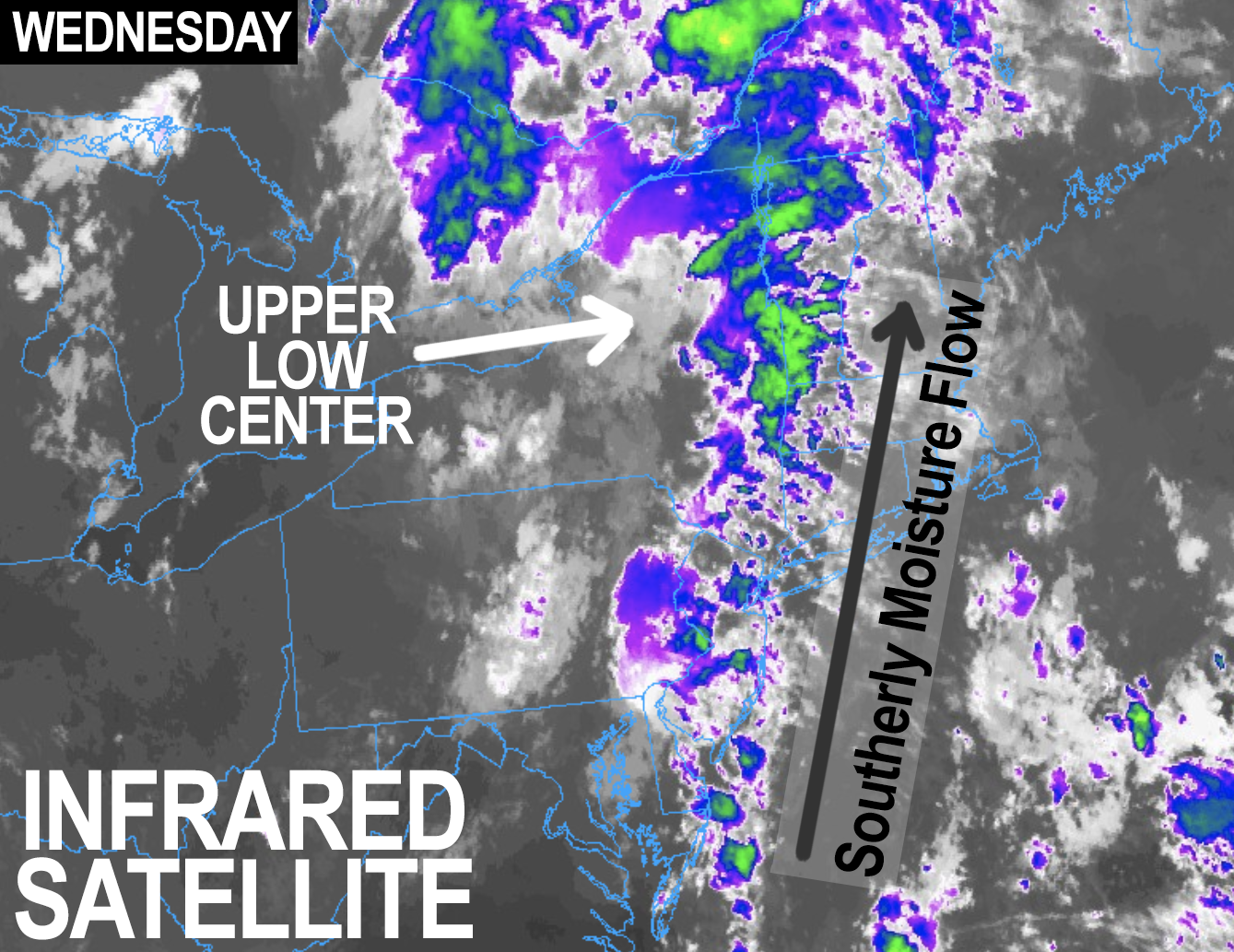
Good morning everybody, we have a wet day for many of us today as an upper level system tracks east out of the Great Lakes and induces a southerly moisture flow into New England.
Showers, with some downpours, are already tracking north-northeast into parts of our region this morning, and more are expected later so packin’ the ‘brellas would be a good move.
Temps are in the upper 60s to low 70s with similar dewpoints, so it’s very muggy, and some patchy fog was noted earlier which will burn off as highs rise to either side of 80º.
A few breaks of sun are possible by afternoon, and in addition, there is some guidance indicating that some heavy rains and a few thunderstorms could form west of the I-91 corridor later this afternoon and track east. Based on this and our super soupy surface atmosphere, I can’t rule out some flash flooding potential, and certainly think we’ll see sporadic areas of street flooding.
Activity winds down tonight as the upper low moves east, and lows will dip to the mid to upper 60s with patchy fog possible.
Behind today’s system, upper ridging moves in with drier air, and for Thursday and Friday we can expect high humidity, partly to mostly sunny skies, and highs in the 85-90º range, with low 90s highs possible on Friday.
This may prompt the hoisting of Heat Advisories for some parts of the greater WMass region, so something to be aware of. Lows each night will be in the 65-70º range.
By Friday later afternoon into evening, clouds should be building as a warm front lifts northeast towards our region, extending off a system that will be pushing into the Ohio Valley.
This may cause showers to develop Friday night, and as we move into the weekend, it looks like we’ll be entering a pre-frontal instability sector that will produce scattered showers, downpours and some thunderstorms each day, with the heaviest rain potential on Sunday.
Highs will reach the 80s both days with lows either side of 70º, and showers or a t-storm is possible Saturday night, and then winding down by Sunday night. Some torrential rain may form on Sunday, so I will be updating on that and keeping an eye on things.
By early next week, we’re in better shape, though should still be humid, but hopefully less so. Highs will reach into the low 80s or so with lows in the 60s as high pressure builds in and brings us more sunshine.
By mid week we watch to our south and our west as a tropical system may try to emerge off of the NC coastline and make a run at us, but as long as a northern stream system passes east through the eastern Great Lakes, that should kick any tropical activity seaward and away from New England with much drier air moving in behind that system.
I will be definitely keeping an eye on that and will update you here, have a great day!
“Follow your bliss and the universe will open doors for you where there were only walls.”
― Joseph Campbell