
TABLE OF CONTENTS
* Daily Celestials (Sun/Moon Data)
* Sponsor Note
* Join My Newsletter (& get my Top12WMassStorms ebook!)
* Morning Discussion
* TIP: Scroll below for sections, or read all
~~~~~~~~~~~~~~~~~~~~~~
YOUR DAILY CELESTIALS
~~~~~~~~~~~~~~~~~~~~~~
STAR:
–OUR STAR ROSE AT: 5:36am this morning
–OUR STAR WILL SET AT: 8:16pm this evening
–TOTAL DAYLIGHT TIME: 14 hours and 40 minutes
MOON:
–OUR MOON WILL RISE AT: 10:28pm this afternoon
–MOON RISE DIRECTION: East
–OUR MOON WILL SET AT: 10:31am tomorrow morning
–MOON SET DIRECTION: West
–MOON PHASE: Waning Gibbous (88.0%)
~~~~~~~~~~~~~~~~~~~~~~
A NOTE FROM OUR SPONSOR
~~~~~~~~~~~~~~~~~~~~~~
Dave Hayes The Weather Nut is Sponsored by Individual Community Members, Patrons, and Tandem Bagel Company… No matter the weather, Tandem Bagel is always there for you at several valley locations to make your mornings brighter! With *New Pizza Bagels(!)*, along with bagels baked fresh daily (including Gluten-Free options), house-whipped cream cheese, coffee, and tons of lunch options, Tandem is the perfect quick stop for lunch, breakfast, or a coffee and bagel to go.
You can either A) visit them in Easthampton, Northampton, Hadley, Florence, and/or West Springfield, B) hire them to cater your next event, or C) use their super-streamlined online ordering tool by visiting their website and clicking the “Catering” or “Order Online” links.
~~~~~~~~~~~~~~~~~~~~~~
DAVE’S WEEKLY NEWSLETTER (Top 12 WMass Storms)
DAVE’S MOBILE APP (Late 2024 Release)
~~~~~~~~~~~~~~~~~~~~~~
YOUR MORNING DISCUSSION
~~~~~~~~~~~~~~~~~~~~~~
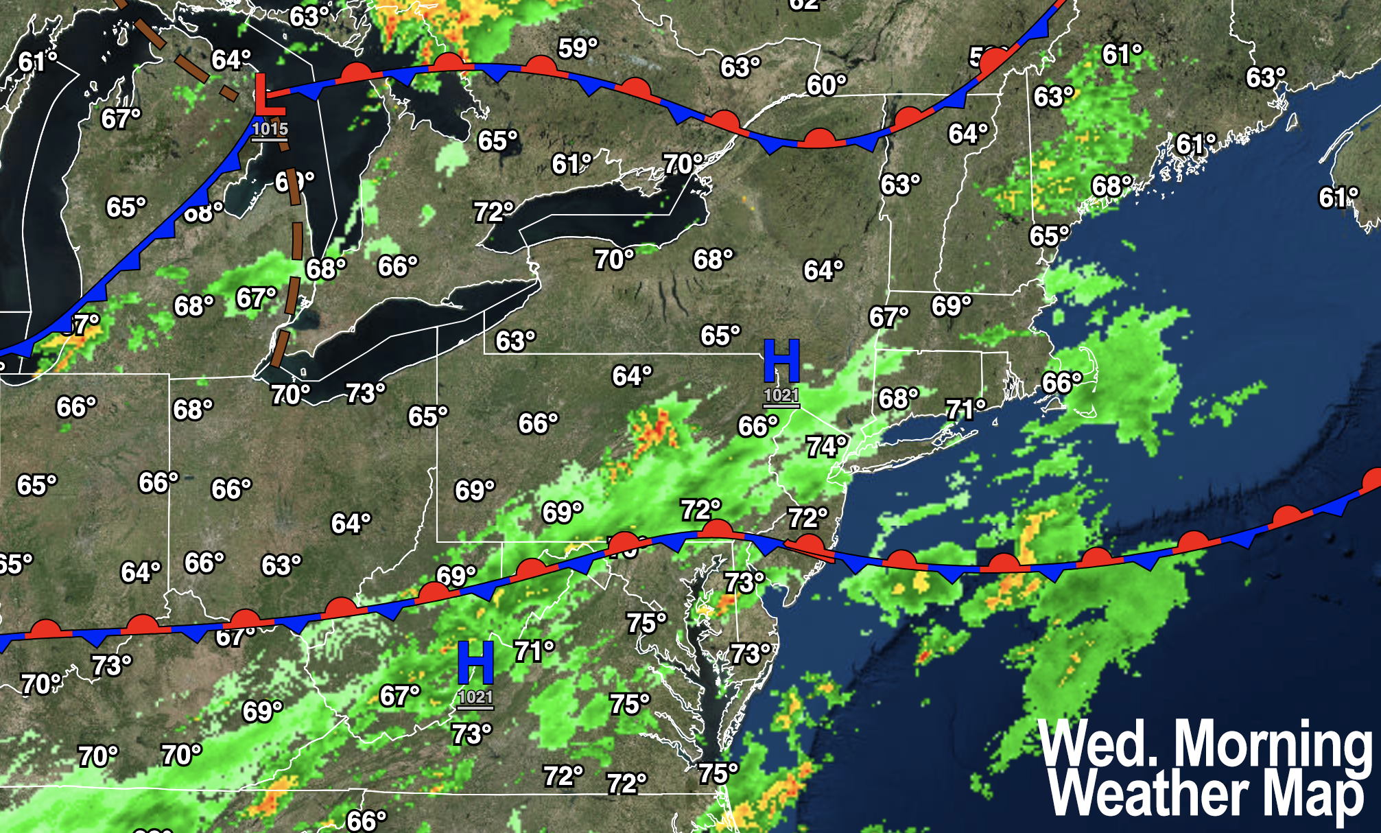
Good morning folks, we are stuck between a front well south of us, a front well north of us, and a storm system in the Great Lakes associated with an upper trough with both tracking east-northeast with time today and tomorrow.
This will eventually drag a pair of cold fronts through the region, but with mostly cloudy skies expected up to and through the cold frontal passage tomorrow, we should see limited strong to severe thunderstorm activity, and most likely just garden variety thunderstorms (without strong gusty winds or large hail).
Unsettled and humid conditions continue today, tomorrow and Thursday with mostly cloudy skies and highs only in the mid to upper 70s today, with lows in the mid to upper 60s and highs tomorrow in the upper 70s to mid 80s.
During this time, isolated showers, downpours or a thunderstorm will be possible, with mostly dry periods mixed in between.
Also, there will be some increased wildfire smoke moving through on Thursday before the cold front approaches, but I am unsure if that will remain elevated or affect ground air quality… just something to be aware of.
By Thursday night, the second cold front should sweep the region, and bring drier air and lows in the upper 50s to low 60s.
Friday through the weekend looks to feature mostly sunny skies with highs in the 80s and lows either side of 60º.
By early next week, high pressure will be building to our south and help to increase our temps into the mid 80s to possibly low 90s by Monday and Tuesday with humid conditions, and mostly sunny skies before more showers and storms are possible during the middle of next week.
Have a great day!
“Follow your bliss and the universe will open doors for you where there were only walls.”
― Joseph Campbell