>>>POST SECTIONS<<<
--DHTWN's Reminder ('Brows Raisin')
--Weekly Nutshell (Overall impact list)
--Sponsor Note (Tandem Bagel Co.)
--NWS Alerts (Advisories, Warnings, Watches)
--Celestial Data (Sun/Moon info)
--Morning Discussion (Detailed Weather Story)
~~~~~~~~~~~~~~~~~~~~~~
>>> DHTWN REMINDER <<<
I've had a hard time in this life, and I basically have a perma-furrowed-brow thing going (plus I get eye glare from being screen-bound for over a decade), but I find that if I can remember to raise my eyebrows at any point during the day and put a small simple smile "on", it helps set a more positive, or at least hopeful tone to the outlook of the day, or even just the next 5 minutes.
What if it ends up only giving you 5-10 minutes of a better mood than you otherwise would have had?
I call that progress, a win, a good thing.
Life is rough mostly, but we have some relative control in our response to what we face.
Hang in there.
~~~~~~~~~~~~~~~~~~~~~~
>>> DAVE’S WEEKLY WEATHER NUTSHELL <<<
--Dry and mostly sunny early today, highs mid to upper 80s
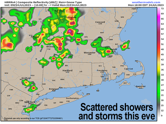
--Some clusters of showers and thunderstorms develop later afternoon with a short-wave passage and increase in humidity
--Some storms may be strong, and we can't rule out isolated flash flooding as the ground is still saturated
--Showers/storms die down tonight, and fire back up tomorrow afternoon as an upper wave moves through, with similar high temps
--High pressure nudges west toward the Carolina coast and causes upper ridging in New England drying up any showers, but also introducing heat and humidity Wednesday-Friday
--Highs likely reach the upper 80s to mid 90s during this 3-days stretch with many of us seeing a heat wave
--It will be quite humid with dewpoints in the upper 60s to mid 70s, but dry for Wednesday and Thursday
--By Friday afternoon or evening some more showers and storms may move back into our region
--We'll be cooling back down this coming weekend, which looks pretty nice right now, but before we talk details let's check a note from our local and delicious sponsor, #TandemBagelCo, with their newest location in the Stop & Shop Plaza on King Street in Northampton, MA.
~~~~~~~~~~~~~~~~~~~~~~
>>> A NOTE FROM OUR SPONSOR <<<
Dave Hayes The Weather Nut is Sponsored by Individual Community Members, Patrons & Tandem Bagel Company... No matter the weather, Tandem Bagel is always there for you at several valley locations to make your mornings brighter! With bagels baked fresh daily (including Gluten-Free options), house-whipped cream cheese, coffee, and tons of lunch options, Tandem is the perfect quick stop for lunch, breakfast, or a coffee and bagel to go. Find them in Easthampton, Northampton, Hadley, Florence, and West Springfield, or use their super-streamlined online ordering tool by visiting their website.
>>> NATIONAL WEATHER SERVICE ALERTS <<< --None >>> YOUR DAILY CELESTIALS <<< STAR: --OUR STAR ROSE AT: 5:35am this morning --OUR STAR WILL SET AT: 8:17pm this evening --TOTAL DAYLIGHT TIME: 14 hours and 42 minutes MOON: --OUR MOON WILL RISE AT: 12:08pm this afternoon --MOON RISE DIRECTION: East --OUR MOON WILL SET AT: 11:34pm tonight --MOON SET DIRECTION: West-Southwest --MOON PHASE: Waxing Crescent (35.7%) >>> MORNING DISCUSSION <<< Good morning everybody, this report will be fairly short today, as I've covered much of our upcoming week in the nutshell above. Essentially it's broken down into three parts. 1. The next two days will feature each afternoon with some scattered showers and thunderstorms thanks to a pair of upper level waves that work through the region and combine with increasing humidity. A few storms may become strong, but severe weather is not expected. Still, we can't rule out some isolated flash flood warnings, so I will keep an eye on things and update accordingly. Highs will be in the mid to upper 80s and humidity will begin to increase, especially tomorrow. 2. The Heat Wave: High pressure over the western Atlantic Ocean flexes and sets up a brief Bermuda high to pump more humid and hotter air southwest to northeast into New England mid to late this week. This is going to cause humidity to build into the region, and temps will soar into the upper 80s to mid 90s under mostly sunny skies. The combo of heat and humidity will cause Heat Indices to rise above 100º, so Heat Advisories will likely need to be hoisted late week. This heat wave will break Friday night with some more showers and thunderstorms, and I will refine timing as we move through the week. 3. The Weekend cool down: This weekend is going to be much cooler, more in the upper 70s to mid 80s with drier conditions as a cold front moves through the region sometime on Saturday, with a few showers possible. Sunday, like this past weekend, will be the pick of next weekend with highs either side of 80º under mostly sunny skies and light northwest flow, which is a cooler wind direction. It's also going to potentially pull in some wildfire smoke, but I will also update on that as we get closer. Have a great day! >>> BE KIND <<< “Hello babies. Welcome to Earth. It's hot in the summer and cold in the winter. It's round and wet and crowded. On the outside, babies, you've got a hundred years here. There's only one rule that I know of, babies: Goddamn it, you've got to be kind.” --Kurt Vonnegut
