Good morning everybody, it’s painfully obvious that this past month has been relentlessly brutal on many folks in our region, and has been one of the worst early summer periods that I can remember — one from which many will be recovering from for a long time in terms of farming operations, infrastructural road repair and redevelopment, and other important public and private works.
Thankfully, that pattern has broken as of this morning.
I am not saying we won’t see anymore periods of heavy rain this summer (or any additional flash flooding) but it is the upper levels that direct atmospheric traffic flow and set the stage for what occurs at the surface where we live and deal with the weather.
The wintry setup of an upper/eastern trough always being to our west and dropping disturbances through the region as it has this early summer is waning, and now we have an upper level ridge in the western Atlantic and in the east which is waxing.
This will provide days of dry, sunnier weather conditions into next week, but before we talk details let’s check a note from our local weekend sponsor, #GerardGhazeyBatesPC, an estate planning law firm in Northampton, MA.
~~~~~~~~~~~~~~~~~~~~~~
>>> A NOTE FROM OUR SPONSOR <<<
Dave Hayes The Weather Nut is Sponsored by Individual Community Members, Patrons & Gerard, Ghazey & Bates, P.C. GGBPC is a Northampton-based law firm regarded as the voice of pragmatic and well-reasoned estate planning, elder law and tax guidance in Western Massachusetts. The firm specializes in estate planning law, and expertly handles other matters such as Elder Law, Tax Law, as well as Real Estate purchase, sales, and refinance transactions. Contact GGBPC today to see how they can help!
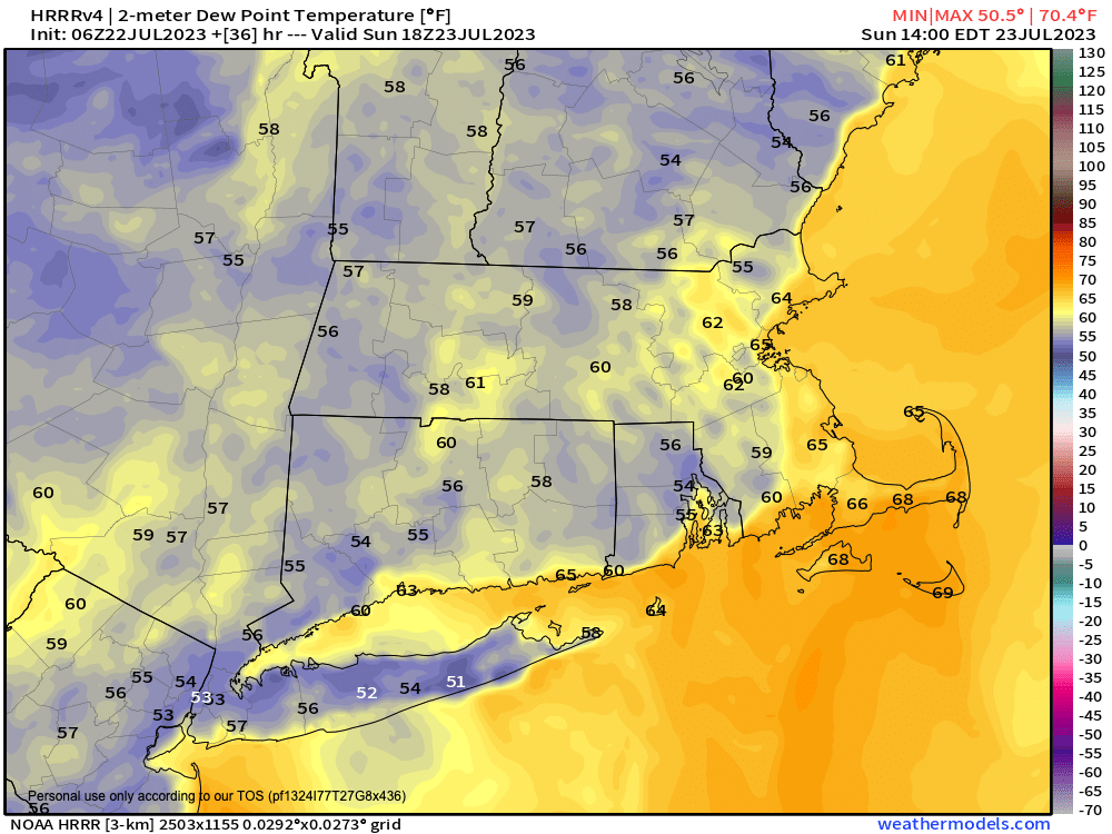
>>> MORNING DISCUSSION <<< As for our tomorrow, I am likely going to take a day to sleep in. I am exhausted from the past month, and am in need of rest on all levels, so probably no report tomorrow, as today's will cover the entire weekend, and tomorrow's weather will be gem-like in its quality and perfectly serene. SUMMARY: --Patchy fog will burn off this morning, and reveal a mostly sunny day with highs in the upper 70s to low 80s and improving humidity --Lows tonight will dip into the mid to upper 50s as dewpoints continue to decrease and drier air works into the region --Sunday, as I said yesterday, will the pick of the summer, with highs in the low to mid 80s, low humidity with dewpoints 55-60º (see attached chart), sunny skies, and light wind with lows near 60º --Monday looks a bit warmer with highs well into the 80s for all, including some upper 80s in the lower valley --We can't rule out an isolated shower in the hills, but I think it's a dry day. Lows will be in the low 60s --At the moment, shower chances look to dry up and succumb to the building western Atlantic ridge which will continue to exert its drying influence on our region --Highs will be well into the 80s Tuesday and Wednesday, with humidity definitely increasing back to muggy levels --By Thursday and Friday, we should be seeing temps come up into the upper 80s to low 90s, and perhaps even mid 90s by Friday as heat peaks late week --Mostly sunny skies are expected during this period as well, so traditional summer weather is on the march into New England during the last full week of July Have a great day, and if you have any additional pics, vids, or reports, including road condition reports, closures, or other important to share regarding yesterday's flooding, please post below for others. Thank you, Dave. >>> BE KIND <<< “Hello babies. Welcome to Earth. It's hot in the summer and cold in the winter. It's round and wet and crowded. On the outside, babies, you've got a hundred years here. There's only one rule that I know of, babies: Goddamn it, you've got to be kind.” --Kurt Vonnegut
