DHTWN’S WEEKLY NUTSHELL
–Patchy fog breaks up this morning and absorbs into the ethers like we all will some day
–Accepting our mortality helps us put the blessing of our lives in perspective, and helps us handle the down times, and create better up times
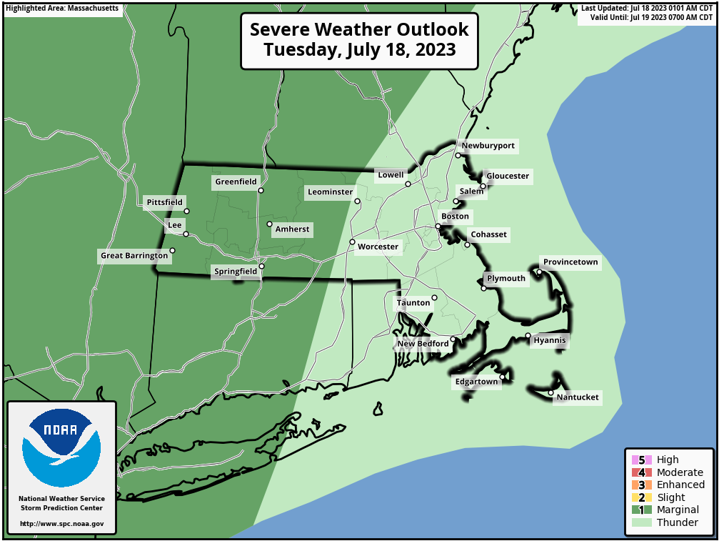
–Like today: it’s going to be cloudier, and we’ll see scattered showers and thunderstorms, and some might be strong to severe with strong wind gusts or larger hail, and we may see some isolated flash flooding
–That won’t be fun, but tomorrow and Thursday look a lot nicer, calmer, and with less smoke than these past tow days, so the bad weather puts the good in perspective, and can heighten our experience of it
–After a pair or drier and warm/humid days, Thursday night into Friday looks pretty wet, wetter than today, for example
–This could be another day for isolated flash flooding, but if my eyes don’t deceive me, we could be entering a three-day dry spell OVER THE WEEKEND, but before we talk details let’s check a note from our local and delicious sponsor, #TandemBagelCo, with their newest location in the Stop & Shop Plaza on King Street in Northampton, MA.
~~~~~~~~~~~~~~~~~~~~~~
>>> A NOTE FROM OUR SPONSOR <<<
Dave Hayes The Weather Nut is Sponsored by Individual Community Members, Patrons & Tandem Bagel Company... No matter the weather, Tandem Bagel is always there for you at several valley locations to make your mornings brighter! With bagels baked fresh daily (including Gluten-Free options), house-whipped cream cheese, coffee, and tons of lunch options, Tandem is the perfect quick stop for lunch, breakfast, or a coffee and bagel to go. Find them in Easthampton, Northampton, Hadley, Florence, and West Springfield, or use their super-streamlined online ordering tool by visiting their website.
>>> MORNING DISCUSSION <<< Good morning everybody, I think I've mentioned it before, but of course I truly hope this past Sunday's flooding event is the finale of this lousy pattern in which we've found ourselves for weeks now. We do have two more wet installments to append to said pattern, and the first one is today. This frontal passage will not be like the massive light show the other day which was a widespread squall line that produced dozens of Severe Thunderstorm Warnings. First, we'll start off today with patchy fog which will burn off into a mostly cloudy day with a few sunny breaks possible. Highs will be well into the 80s with a muggy feel for sure. We'll also be dealing with haze, and wildfire smoke, and folks with respiratory issues or sensitivities should limit outdoor time. A frontal boundary will be pushing east through NY and PA and will push a bit of wind shear into the region and be preceded by instability and increasing moisture pushing north into New England, ahead of this front. These factors (frontal lift, wind shear, and moisture / instability) will combine to produce scattered showers, downpours and thunderstorms in the early to mid afternoon today. A storm or two may become strong to severe, with localized damaging wind gusts possible, or larger hail. Otherwise, heavy rain will be the main threat, and a couple of flash flood warnings may need to be issued. This activity should mainly be around in scattered form from 2pm-8pm today, and then wane at night. Lows will drop to the low to mid 60s. For Wednesday into Thursday, we've got some ridging that will build in, and hopefully this time with less smoke, which I believe will be the case. Highs will reach the upper 70s to mid 80s under mostly sunny skies Wednesday with a light west wind and we may get a small decrease in humidity as temps drop into the upper 50s to low 60s on Wednesday night. Thursday starts off very nice with sunshine and highs in the low to mid 80s, but as a warm front pushes toward the region, clouds will develop, and a few showers are possible by evening. Thursday night into Friday morning features some warm frontal showers, but they shouldn't be too too heavy. It is Friday afternoon when we have to be concerned about heavy rain and thunderstorm potential with an incoming cold front tied to a storm that will pass well northwest of us. This could bring some additional isolated flash flooding concerns, but again, I think we are starting to move past the widespread flood issues with the passing of this week, at least that is how it looks now. The weekend ahead looks GORGEOUS. Mostly sunny skies Saturday, Sunday and Monday with highs in the upper 70s to mid 80s, hopefully way less smoke, lower humidity, and only a few afternoon showers possible Saturday. I am not getting my hopes up, but this is the best fair weather signal I have seen since Summer began almost a month ago, so here's hoping! Have a great day! >>> BE KIND <<< “Hello babies. Welcome to Earth. It's hot in the summer and cold in the winter. It's round and wet and crowded. On the outside, babies, you've got a hundred years here. There's only one rule that I know of, babies: Goddamn it, you've got to be kind.” --Kurt Vonnegut
