>>> DAVE’S WEEKLY WEATHER NUTSHELL <<<
--Patchy fog this morning, some dense, in part due to condensation forming on smoke particulate matter
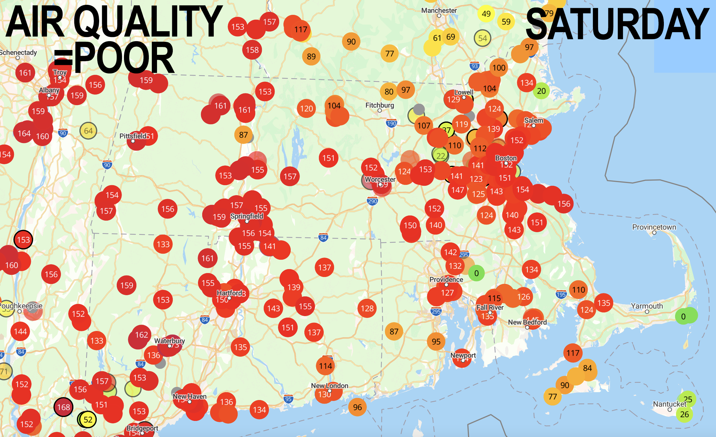
--Air Quality remains mostly poor today with isolated exceptions
--It will take all day and tonight before a new air mass begins to advect east in and push smoke out for tomorrow
--It will be warm throughout the weekend
--As smoke pushes out, humidity pushes in, as does scattered shower and thunderstorm chances
--We could see scattered showers and storms at any point during Sunday through Tuesday, but Monday could produce a strong to severe storm with damaging wind gusts
--After a wet-for-some, dry-for-others 4th of July, we heat up into the 80s and low 90s, with heat indices pushing into the mid 90s, but before we talk details let's check a note from our local weekend sponsor, #GerardGhazeyBatesPC, an estate planning law firm in Northampton, MA.
~~~~~~~~~~~~~~~~~~~~~~
>>> A NOTE FROM OUR SPONSOR <<<
Dave Hayes The Weather Nut is Sponsored by Individual Community Members, Patrons & Gerard, Ghazey & Bates, P.C. GGBPC is a Northampton-based law firm regarded as the voice of pragmatic and well-reasoned estate planning, elder law and tax guidance in Western Massachusetts. The firm specializes in estate planning law, and expertly handles other matters such as Elder Law, Tax Law, as well as Real Estate purchase, sales, and refinance transactions. Contact GGBPC today to see how they can help!
>>> MORNING DISCUSSION <<< Good morning everybody, as always, remember to click through the photos/graphics as they’ve normally have info on them, or in the captions. For this morning, patchy fog (some dense) will slowly burn off revealing another partly sunny day, but it will be filtered through more haze and smoke from the Quebec wildfires. As you may or may not know, provincially Quebec just lets their fires burn - they don't mitigate them, or put them out, they let nature run its course, which is why we are dealing with this issue again. Folks with respiratory illnesses and sensitivities must spend time indoors and/or wear masks. Highs will reach the low to mid 80s as clouds build in later, above the smoke and haze, and winds will be light. A warm front begins to push toward the region tonight into Sunday morning, and as such as humidity will start to increase as clouds thicken, and a few showers are possible before midnight, but likely hold off until the pre-dawn or early morning hours of Sunday. Lows will be in the low/mid 60s. For Sunday, we could start off with patchy dense fog, and should be seeing improvements with decreasing smoke/haze, but humidity will be increasing with dewpoints rising into the 60s and low 70s, so it will become quite muggy and scattered showers with some heavy rain will work into the region with the warm frontal approach. Highs will only be in the 70s due to cloud cover, and we could see a couple of rounds of showers with maybe a thunderstorm into the night with lows in the mid to upper 60s with more patchy dense fog possible. Monday is the best chance for seeing a strong to severe thunderstorm or three as humidity builds and our upper low gets closer to the region with an impulse moving through the flow. This would occur most likely in the afternoon, but I will update as we get closer. Folks with plans to attend James Taylor at Tanglewood (including this writer) should stay tuned for updates. The hope is that any storm lines move through in the mid to late afternoon before show start. Some storms could contain damaging wind gusts with torrential rain, so stay tuned. Highs will reach the upper 70s to mid 80s with lows in the 60s and a few more showers possible, or a thunderstorm or two as the upper low moves through the region. Highs will reach well into the 80s, pushing 90º in a few spots, and it will be quite humid under partly sunny skies, and again, with a lower chance for showers or a storm. By the mid to late week period, high pressure will set up favorably to produce southerly flow, more sunshine, humid conditions, and highs in the mid 80s to low 90s with heat indices into the mid 90s or so, so we're going to see the 4th of July holiday kick off the beginning of the heart of summer weather from what I can see! Thanks very much and have a great day! >>> BE KIND <<< “Hello babies. Welcome to Earth. It's hot in the summer and cold in the winter. It's round and wet and crowded. On the outside, babies, you've got a hundred years here. There's only one rule that I know of, babies: Goddamn it, you've got to be kind.” --Kurt Vonnegut
