
TABLE OF CONTENTS
* Daily Celestials (Sun/Moon Data)
* Weekly Weather Nutshell
* Morning Discussion
* TIP: Scroll below for sections, or read all
~~~~~~~~~~~~~~~~~~~~~~
YOUR DAILY CELESTIALS
~~~~~~~~~~~~~~~~~~~~~~
STAR:
–OUR STAR WILL RISE AT: 7:18am this morning
–OUR STAR WILL SET AT: 4:36pm this evening
–TOTAL DAYLIGHT TIME: 9 hours and 18 minutes
MOON:
–OUR MOON WILL SET AT: 2:22pm this afternoon
–MOON SET DIRECTION: Southwest
–OUR MOON WILL RISE AT: 6:56am tomorrow morning
–MOON RISE DIRECTION: Southeast
–MOON PHASE: Waning Crescent (5.6%)
~~~~~~~~~~~~~~~~~~~~~~
A NOTE FROM OUR SPONSOR
~~~~~~~~~~~~~~~~~~~~~~
Dave Hayes The Weather Nut is Sponsored by Individual Community Members, Patrons, and Tandem Bagel Company… No matter the weather, Tandem Bagel is always there for you at several valley locations to make your mornings brighter! With bagels baked fresh daily (including Gluten-Free options), house-whipped cream cheese, coffee, and tons of lunch options, Tandem is the perfect quick stop for lunch, breakfast, or a coffee and bagel to go. Find them in Easthampton, Northampton, Hadley, Florence, and West Springfield, or use their super-streamlined online ordering tool by visiting their website.
~~~~~~~~~~~~~~~~~~~~~~
YOUR WEEKLY WEATHER NUTSHELL
~~~~~~~~~~~~~~~~~~~~~~
–Clear your street drains and dig out fire hydrants today if you can and didn’t yesterday
–We start off cold in the teens and low 20s
–Southerly wind will rise our temps up into the low to mid 30s today, with some upper 30s in northern CT
–This means when precip arrives with cold snow pack in place, many of us snow or snow/rain mix, rain in north-central and northeast CT into southernmost CMass
–Snow and rain arrives between 3-6pm, and it will snow hard for a while in the high terrain (Berkshires, western hiilltowns, SVT, SWNH and northern CMass, possibly in N. Litchfield County, too)
–1-3″ in northern Worcester County and northern Litchfield up into southern Berkshires / western Hampden, and more like 2-5″ in rest of western hilltowns, northern Berkshires, and SWNH, with 4-8″ in highest elevations of SVT, maybe a ski slope clocks 10″
–Temps be increasing overnight with changes to rain, and rain will fall hard at times toward and after midnight, 1.5-3.5″ possible
–Southeast winds will gust 25-40mph in the low elevations of the valley starting this evening, with 40-60mph possible in the high terrain
–Outages (due to wind and wet snow combo, as well as just wind in the higher gusts) are expected in spots, so charge your devices
–The frontal boundary passes and heaviest weather quits around sunrise or so with temps in the 30s and 40s by morning
–A final impulse brings heavier rain and snow showers through by late morning, then west winds gust over 30mph as colder air comes back into the region with lows in the 20s at night
–Lake effect/upslope snow showers Wednesday night into Thursday with a new 1-2″ in the N. Berkshirs and SVT by Thursday night
–Another storm comes in on Friday night with snow rain and wind lasting into Saturday
–Winter pattern resumes with cold air by Sunday into next week just in time for a 4th storm to arrive, and this one could be very snowy and windy
–2024 starts off with 4 bangs in the weather department, so keep it tuned here, I’m all over it throughout, here to serve
~~~~~~~~~~~~~~~~~~~~~~
YOUR MORNING DISCUSSION
~~~~~~~~~~~~~~~~~~~~~~
Good morning everybody, we’ve got a very cold morning out there with temps in the teens and low 20s, with even some single digits reported earlier at Orange, MA and Keene, NH, as well as for some towns in southern VT.
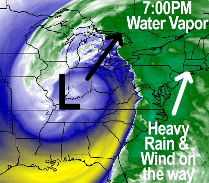
Clouds will thicken up today as our truly massive and potent storm system winds up like a giant cinnamon bun and hurls its not-so-sweet surprises northeast from the center of the country toward Lake Erie, and by later this afternoon into our neck of the woods.
I am ALWAYS skeptical of anticipated temperature rises due to southerly flow in the valley after it’s been very cold AND with deep snow pack in place, which acts like a refrigerator — it’s historically hard to dislodge cold from the Pioneer Valley.
That said, I think highs will rise into the low to mid 30s today, perhaps upper 30s in northern CT, and this should all many of us north of the Pike to start as snow, though the valley south of Greenfield may be a rain/snow mix, with plain rain in much of northern CT, except northwest CT (northern Litchfield and northwest Hartford Counties should snow at first).
Slushy coatings will be possible in much of the valley, and if the precip hits hard and heavy, which it could, that would make us snow for a bit longer so there’s a low chance even the valley picks up a quick inch.
Generally, however, we should be changing to rain in the valley of WMass points south and east.
SNOW AMOUNTS
1-3″ should do it in northern Worcester County into eastern Franklin County and the southern Berkshires into western Hampden County into northernmost Litchfield County.
2-5″ for northern Berkshires, western Hampshire/Franklin Counties, western Bennington County and eastern Windham County VT into southwest NH.
4-8″ in the southern Greens of VT with up to 10″ on a few ski slope peaks.
Snow will be wet, and getting wetter between 4pm-Midnight or so.
WIND
Southeasterly wind gusts will pick up later this afternoon and into the overnight hours with gusts in the valley well north of Hartford CT up to about Greenfield of 25-40mph.
However, elsewhere gusts will range from 35-60mph with highest speeds in the Berkshires and Bennington VT into eastern NY.
This is where heavy wet snow and high wind may combine to produce areas of more widespread power outages, so charge up your devices.
RAIN/FLOODING
Heavy, torrential rain will develop late tonight and after midnight through about 6am or so, and this could cause flash flooding of streets and streams, so please clear any drains that you can.
Rainfall of 1.5-3.5″ is expected, and it is parts of Hampden County into southern CMass down into north-central and northeast CT where snow pack could be wiped out fastest by warming temps and heavy rain, so that could where flooding sets up in earnest, but flooding is possible anywhere in our region overnight.
AFTER WEDNESDAY EARLY MORNING
The front of heavy weather clears our region to the northeast and a last round of rain and snow showers should move through by late morning as colder air works back into the region from the west with mixed skies.
This will cause temps in the 30s and 40s tomorrow morning to fall back into the 20s at night, with upslope and lake effect snow showers developing into eastern NY, the Berkshires and SVT through Thursday.
Thursday looks partly sunny with highs 35-40º, and a fresh inch or two is possible by Thursday night from snow showers.
By Friday, we are setting up to do it all over again with another strong low poised to track to our west, sending more snow and rain into our region, though that storm doesn’t look as potent as this one at the moment, though it’s no slouch, either.
By Saturday afternoon we should be clearing out from that storm and behind that comes much colder air, which represents the easterly edge of an Arctic air mass that will first empty into the center of the country by next week.
It looks cold next week, and yet ANOTHER (that would be the 4th in series that is playing out now) storm system, and this one could be full on snowy, windy nor’easter with a deep coastal low forming, so please stay tuned for updates and I will post again today regarding tonight’s tempest.
Have a great day, it’ll be dry until abouot 3-5pm when things start becoming inclement.
>>> BE KIND <<<
“Hello babies. Welcome to Earth. It’s hot in the summer and cold in the winter. It’s round and wet and crowded. On the outside, babies, you’ve got a hundred years here. There’s only one rule that I know of, babies: Goddamn it, you’ve got to be kind.”
–Kurt Vonnegut