
TABLE OF CONTENTS
* Daily Celestials (Sun/Moon Data)
* Sponsor Note
* Morning Discussion
* TIP: Scroll below for sections, or read all
~~~~~~~~~~~~~~~~~~~~~~
YOUR DAILY CELESTIALS
~~~~~~~~~~~~~~~~~~~~~~
STAR:
–OUR STAR RISES AT: 7:18am this morning
–OUR STAR WILL SET AT: 4:36pm this evening
–TOTAL DAYLIGHT TIME: 9 hours and 18 minutes
MOON:
–OUR MOON RISES AT: 11:58am this morning
–MOON RISE DIRECTION: East-Northeast
–OUR MOON WILL SET AT: 3:01am tomorrow morning
–MOON SET DIRECTION: West-Northwest
–MOON PHASE: Waxing Gibbous (66.9%)
~~~~~~~~~~~~~~~~~~~~~~
A NOTE FROM OUR SPONSOR
~~~~~~~~~~~~~~~~~~~~~~
Dave Hayes The Weather Nut is Sponsored by Individual Community Members, Patrons, and Tandem Bagel Company… No matter the weather, Tandem Bagel is always there for you at several valley locations to make your mornings brighter! With *New Pizza Bagels(!)*, along with bagels baked fresh daily (including Gluten-Free options), house-whipped cream cheese, coffee, and tons of lunch options, Tandem is the perfect quick stop for lunch, breakfast, or a coffee and bagel to go.
You can either 1) visit them in Easthampton, Northampton, Hadley, Florence, and/or West Springfield, 2) hire them to cater your next event, or 3) use their super-streamlined online ordering tool by visiting their website and clicking the “Catering” or “Order Online” links.
~~~~~~~~~~~~~~~~~~~~~~
YOUR MORNING DISCUSSION
~~~~~~~~~~~~~~~~~~~~~~
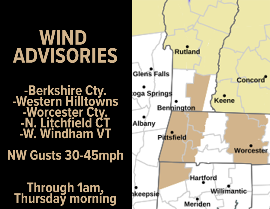
Good morning, folks, the wind kept up all night with gusts in the 25-40mph range with a couple approaching 45mph in the Westfield, MA area!
While that kept temps from plunging down to near 0º, it surely plunged the wind chill readings (a/k/a “apparent temperatures”) down to and below zero, and we’re waking up to a very cold, breezy and in some cases windy morning.
For today, we’ll see some flurries or snow showers at times in far northwest CT, the Berkshires and southwest VT as a shortwave drops south, with generally partly sunny skies in the western high terrain in CT, MA and VT with mostly sunny skies in the valley points east are expected with highs in the upper teens to mid 20s.
Northwest gusts will continue in the 30-45mph range today driving wind chills into the single digits, and wind will keep up tonight 20-35mph with lows in the low to mid 10s under mostly cloudy skies with a few snow showers possible in the Berkshires and SVT. Some isolated outages or tree damage is possible in any peak gusts of 40-50mph.
For Thursday, one more windy day with gusts of 25-40mph are expected with highs in the 20s under mostly sunny skies with a few Berkshire snow showers possible. Lows will dip into the teens under clear skies.
For Friday, a bit of ridging builds in, which means modified temps with highs in the upper 20s to mid 30s under mostly sunny skies with much less wind as the pressure gradient FINALLY eases up, with lows in the teens.
On Saturday, we’ll see our main juicy southern snowstorm tracking well out to sea to our south, probably east of Virginia in terms of latitude, but with a weak northern stream tracking into northern NY, we’ll see some light snow develop, or periods of snow showers, and we could see a coating to 2” or maybe 1-3” on Saturday morning into the afternoon before it quits. I would err on the lower end of those tiny ranges, but I will keep updating as we get closer.
The bottom line is that I don’t see a moderate to major impact from this system given the overall stream flow from a giant low pressure system well south of Greenland staying in place and pulling our southwestern U.S. low pressure system generally west to east across the Deep South, delivering them a rare snowstorm which will cause many headaches for those folks, since they aren’t used to half a foot of snow in northern Alabama, for example.
It’s too bad for snow lovers here in the WMass region, because if things were different and we could pull that storm up the coast, we’d get an old-fashioned “Miller A” type snowstorm, which would put down 1-2 feet across our region.
Such is life… I used to get upset about missing out on snowstorms (and still do a bit), but I’m too old to run my emotions around like that anymore.
Sunday through Tuesday is looking dry, fair, and with highs in the upper 20s to mid 30s which is just about or slight below average.
Some lake effect snow showers are also possible in the Berkshires and SVT early next week, but the next storm chance looks to come around by later next week, and I will keep tabs on it and keep churning out my reports to you on the daily.
Have a great day!
“Follow your bliss and the universe will open doors for you where there were only walls.”
― Joseph Campbell