
TABLE OF CONTENTS
* Daily Celestials (Sun/Moon Data)
* Weekly Weather Nutshell
* Morning Discussion
* TIP: Scroll below for sections, or read all
~~~~~~~~~~~~~~~~~~~~~~
YOUR DAILY CELESTIALS
~~~~~~~~~~~~~~~~~~~~~~
STAR:
–OUR STAR WILL RISE AT: 7:18am this morning
–OUR STAR WILL SET AT: 4:35pm this evening
–TOTAL DAYLIGHT TIME: 9 hours and 17 minutes
MOON:
–OUR MOON WILL SET AT: 1:32pm this afternoon
–MOON SET DIRECTION: Southwest
–OUR MOON WILL RISE AT: 5:50am tomorrow morning
–MOON RISE DIRECTION: Southeast
–MOON PHASE: Waning Crescent (11.6%)
~~~~~~~~~~~~~~~~~~~~~~
A NOTE FROM OUR SPONSOR
~~~~~~~~~~~~~~~~~~~~~~
Dave Hayes The Weather Nut is Sponsored by Individual Community Members, Patrons, and Tandem Bagel Company… No matter the weather, Tandem Bagel is always there for you at several valley locations to make your mornings brighter! With bagels baked fresh daily (including Gluten-Free options), house-whipped cream cheese, coffee, and tons of lunch options, Tandem is the perfect quick stop for lunch, breakfast, or a coffee and bagel to go. Find them in Easthampton, Northampton, Hadley, Florence, and West Springfield, or use their super-streamlined online ordering tool by visiting their website.
~~~~~~~~~~~~~~~~~~~~~~
YOUR WEEKLY WEATHER NUTSHELL
~~~~~~~~~~~~~~~~~~~~~~
–Clear your street drains today, and clear them again tomorrow
–Partly to mostly sunny today, highs in the 30s
–Northwest winds may gust to 20mph, and then slacken
–Lows tonight in the teens, cold, clouds increasing
–Southwest flow develops due to a storm well west of us
–Highs reach the mid 30s to low 40s, becoming overcast
–Snow and rain arrives after sunset tomorrow evening
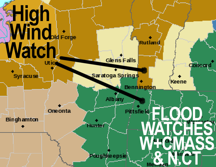
–Accumulating wet snow expected in the eastern Berkshires, western hilltowns, northern Worcester highlands, and mountains of SVT and SWNH
–Can’t rule out 3-6″ in the high terrain west of I-91 and 1-3″ east of I-91, before changing to sleet and rain
–Lows will be in the 30s Tuesday night, but should rise into the 40s after midnight
–This may help strong to possibly damaging wind mix down into the high terrain with outages possible
–Snow pack may help keep strong wind from making it into the valley and lower elevations
–Elsewhere, rain/snow mix in the valley turns to all rain, and rain falls heavily at times everywhere after midnight, up to 1-3″ of rain by Wednesday noon
–Highs will reach the 40s to near 50º and then fall back with lows ini the 20s
–Street and stream flooding due heavy rain and snow melt is probable in some spots, so please clear your street drains and municipalities should do the same if resources allow it
–The rain clears out of here by mid morning Wednesday, then cooler air works in on westerly winds behind the frontal passage
–Lake effect snow showers possible Wednesday evening into Thursday as well with highs in the mid 30s to low 40s Thursday and Friday
–A twin of this Tuesday/Wed system likely arrives Friday night into Saturday and we do it all over again, though probably with less accumulating snow on the front end, but similar impacts possible
–Sunday is the pick of next weekend by far, and we should resume a colder, seasonable winter pattern after these two rainy systems
~~~~~~~~~~~~~~~~~~~~~~
YOUR MORNING DISCUSSION
~~~~~~~~~~~~~~~~~~~~~~
Good morning everybody, it surely is a winter wonderland out across the region today, and cold with temps in the 20s with some upper teens in SVT.
Today is the calm before the storm with high pressure building into the region for a day. Northwest winds may gust up to 20mph putting a nip to the air as highs climb into the low to mid 30s, but winds will slacken as the high works into and through the region.
This will cause lows to drop into the teens tonight as clouds increase late.
A potent low pressure system will be deepening rapidly over the southern Plains and track northeast into the Great Lakes region tomorrow night into early Wednesday.
The upper low portion of this system will be tilting negatively WEST of us, and send a powerful cold front our way, which will be siphoning deep southerly moisture northward up the eastern seaboard.
Meanwhile, after highs in the mid 30s to low 40s Tuesday with overcast skies, a deep snow pack lays in wait for this moisture to arrive, and it will be dry ahead of this system.
As the heavy precipitation moves in after sunset tomorrow evening, evaporative cooling will drop temps and cause a snow/rain mix to go to all snow, and wet snow at that, over the Berkshires, western hilltowns, the Worcester highlands, and along the Route 2 corridor in Franklin County north into SVT and SWNH.
While any northern valley areas may see some slushy coatings to an inch of wet slop, it is the high terrain areas on either side of the CT river (especially west of the river) that will see a change to heavy wet snow, which could accumulate 2-6″ west of the river before midnight, and 1-3″ or so east of the river above 1000-1500 feet.
In fact, I would not be surprised if a swath of 4-8″ falls in the southern Greens.
As this happens, southeast winds will be gusting up to 30mph or so, which could cause outages to begin in SVT.
As milder air invades north at all levels, snow eventually turns to heavy rain overnight everywhere, first in the valley of WMass (it will be all rain in northern CT except briefly in northern Litchfield County), then proceeding northward.
After midnight, with heavy rain on top of melting snow pack as temps climb above freezing, street and stream flooding will likely occur in some spots.
In addition, snow pack will keep temps cooler in the valley, but west of the CT River where a bit less snow fell and temps will probably warm quicker with a southeast low level jet streak moving through (a faster moving river of air about a mile up), high wind gusts of 40-60mph may develop, especially over the high terrain in the western hilltowns, Berkshires and SVT, which could cause more outages when combined with heavy wet snow.
This is a multi-hazard messy system on the way.
Please, please located your fire hydrants and storm drains and clear them if they are not cleared yet to mitigate street flooding, and if municipalities have the resources to do so, maybe they can help, if possible.
This storm clears out of here Wednesday morning fast, and sun comes out by afternoon!
Highs in the 40s will crash into the 20s at night as colder air works into the region, along with a chance for lake effect snow showers in the Berkshires and SVT Wednesday night into Thursday.
The late week period features highs either side of 40º, prior to another snow to rain system Friday night into Saturday that looks VERY similar to the one we’re about to endure.
That could cause additional flooding and wind issues with some outages possible, so please stay tuned all week and I will keep you updated.
If you’re a skier and have time and flexibility, today and tomorrow are your days to hit the slopes! Have a great day.
>>> BE KIND <<<
“Hello babies. Welcome to Earth. It’s hot in the summer and cold in the winter. It’s round and wet and crowded. On the outside, babies, you’ve got a hundred years here. There’s only one rule that I know of, babies: Goddamn it, you’ve got to be kind.”
–Kurt Vonnegut